Great Brehat

Last updated
Great Brehat
Canada Newfoundland relief location map.jpg
Red pog.svg
Great Brehat
Location of Great Brehat
Canada relief map 2.svg
Red pog.svg
Great Brehat
Great Brehat (Canada)
Coordinates: 51°25′40″N55°29′53″W / 51.42778°N 55.49806°W / 51.42778; -55.49806 Coordinates: 51°25′40″N55°29′53″W / 51.42778°N 55.49806°W / 51.42778; -55.49806
Country Flag of Canada (Pantone).svg  Canada
Province Flag of Newfoundland and Labrador.svg  Newfoundland and Labrador
Settled16th century
Population
 (2016)
  Total95
Time zone UTC−03:30 (Newfoundland Time)
  Summer (DST) UTC−02:30 (Newfoundland Daylight)
Area code(s) 709

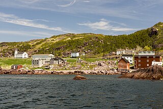
Great Brehat is a local service district and designated place in the Canadian province of Newfoundland and Labrador. It is on the Great Northern Peninsula of the island of Newfoundland, 10 km north of St.Anthony. As fishing has declined, the village has become a tourist attraction. [1]

Contents

History

The original settled indigenous peoples were of the Dorset culture, and the area was visited by the Vikings, as their settlement at L'Anse aux Meadows was only 46 km away. By the sixteenth century the area was occupied by the Beothuk.

When the French settled the northern peninsula ("The French Shore") of Newfoundland they established several fishing stations including Great Brehat. The people were from Brittany and named their village after an island off the Brittany coast. [2] The exact date of the French settlement is not known. In 1713, with the Treaty of Utrecht, the French ceded the peninsula to Great Britain. Until the decline of the fishery in the 20th century, the primary catch was cod for export.

At the beginning of the 20th century, a co-operative store was opened in the village with the assistance of the medical missionary Sir Wilfred Grenfell. [2] The first road linking the coastal communities of the area was completed in 1971, [2] with Great Brehat being the northern terminus.

Geography

Great Brehat is in Newfoundland within Subdivision D of Division No. 9. [3] Great Brehat is located on a small bay, Great Brehat Bay, on the eastern side of the Great Northern Peninsula. Flat Point Lookout is located at the northern end of the bay. Brehat Point forms the southern boundary of the bay. The black shales in the area may yield precious metals. [4]

Demographics

As a designated place in the 2016 Census of Population conducted by Statistics Canada, Great Brehat recorded a population of 88 living in 34 of its 39 total private dwellings, a change of

Government

Great Brehat is a local service district (LSD) [6] that is governed by a committee responsible for the provision of certain services to the community. [7] The chair of the LSD committee is Ryan Cull. [6]

See also

Related Research Articles

Piccadilly Slant-Abrahams Cove Local service district / designated place in Newfoundland and Labrador, Canada

Piccadilly Slant-Abraham's Cove is a local service district and designated place in the Canadian province of Newfoundland and Labrador. It is located on the island of Newfoundland, along St. George's Bay, on the Port au Port Peninsula. The DPL consists of the fishing villages of Abraham's Cove and Piccadilly.

Brigus South is a local service district and designated place in the Canadian province of Newfoundland and Labrador on the Avalon Peninsula.
Open Hall-Red Cliffe

Open Hall-Red Cliffe is a local service district and designated place in the Canadian province of Newfoundland and Labrador.

Rock Harbour, Newfoundland and Labrador Local service district / designated place in Newfoundland and Labrador, Canada

Rock Harbour is a local service district and designated place in the Canadian province of Newfoundland and Labrador. It is east of Marystown on Placentia Bay.

Epworth-Great Salmonier is a local service district and designated place in the Canadian province of Newfoundland and Labrador. It is on the Burin Peninsula of the island of Newfoundland.

Sheaves Cove

Sheaves Cove is a local service district and designated place in the Canadian province of Newfoundland and Labrador. It is on the Port au Port Peninsula along the shore of St. George's Bay. There is a small tourist alcove just off the highway where views of the waterfalls and the ocean are visited often.

Ship Cove-Lower Cove-Jerry's Nose is a local service district and designated place in the Canadian province of Newfoundland and Labrador.

Petite Forte, Newfoundland and Labrador Local service district / designated place in Newfoundland and Labrador, Canada

Petite Forte is a local service district and designated place in the Canadian province of Newfoundland and Labrador. It is on Placentia Bay and is connected by road via Route 215. Petite Forte is located on the Burin Peninsula which is on the southeast coast of the island of Newfoundland in the province of Newfoundland and Labrador. It fought attempts by the government in the 1960s to resettle. Petite Forte has a population of 57 according to the 2016 census.

Black Duck Brook and Winterhouse, Newfoundland and Labrador

Black Duck Brook and Winterhouse is a local service district and designated place in the Canadian province of Newfoundland and Labrador. It consists of the unincorporated fishing settlements of Black Duck Brook and Winterhouse on the Port au Port Peninsula. The communities had a combined population of 57 in the Canada 2006 Census.

Normans Bay

Norman's Bay is a local service district and designated place in the Canadian province of Newfoundland and Labrador. It is an isolated community at the head of Norman Bay, an extension of Martin Bay. The population of the community was 25 in the 2016 census.

Black Duck Cove, Great Northern Peninsula, Newfoundland and Labrador Settlement in Newfoundland and Labrador, Canada

Black Duck Cove is a local service district and designated place in the Canadian province of Newfoundland and Labrador. It is on the Great Northern Peninsula of Newfoundland.

Birchy Cove

Birchy Cove is a local service district and designated place in the Canadian province of Newfoundland and Labrador.

Wild Cove is a local service district and designated place in the Canadian province of Newfoundland and Labrador. It is on the Baie Verte Peninsula of the island of Newfoundland.

Bear Cove, Northern Peninsula, Newfoundland and Labrador Local service district / designated place in Newfoundland and Labrador, Canada

Bear Cove is a local service district and designated place in the Canadian province of Newfoundland and Labrador on the northern peninsula of the island of Newfoundland.

Burnt Point-Gull Island-Northern Bay, Newfoundland and Labrador Local service district / designated place in Newfoundland and Labrador, Canada

Burnt Point-Gull Island-Northern Bay is a local service district and designated place in the Canadian province of Newfoundland and Labrador.

Forresters Point, Newfoundland and Labrador Local service district / designated place in Newfoundland and Labrador, Canada

Forresters Point is a local service district and designated place in the Canadian province of Newfoundland and Labrador.

Pidgeon Cove-St. Barbe, Newfoundland and Labrador Local service district / designated place in Newfoundland and Labrador, Canada

Pidgeon Cove-St. Barbe is a local service district and designated place in the Canadian province of Newfoundland and Labrador.

Ship Cove, Northern Peninsula, Newfoundland and Labrador Local service district / designated place in Newfoundland and Labrador, Canada

Ship Cove is a local service district and designated place in the Canadian province of Newfoundland and Labrador on the northern peninsula of the island of Newfoundland.

St. Josephs Cove-St. Veronicas, Newfoundland and Labrador Local service district / designated place in Newfoundland and Labrador, Canada

St. Joseph's Cove-St. Veronica's is a local service district and designated place in the Canadian province of Newfoundland and Labrador.

Valley Pond, Newfoundland and Labrador Local service district / designated place in Newfoundland and Labrador, Canada

Valley Pond is a local service district and designated place in the Canadian province of Newfoundland and Labrador.

References

  1. "Icebergs anchor in St. Anthony Bight, St. Carol's and Great Brehat!". Live Rural Newfoundland & Labrador.
  2. 1 2 3 "Great Brehat". Great Northern Peninsula.
  3. "Population and dwelling counts, for Canada, provinces and territories, census divisions, census subdivisions (municipalities) and designated places, 2016 and 2011 censuses – 100% data (Newfoundland and Labrador)". Statistics Canada. February 7, 2018. Retrieved December 23, 2021.
  4. "Great Brehat Property". Metals Creek Resources Corp.
  5. "Population and dwelling counts, for Canada, provinces and territories, and designated places, 2016 and 2011 censuses – 100% data (Newfoundland and Labrador)". Statistics Canada. February 7, 2018. Retrieved December 22, 2021.
  6. 1 2 "Directory of Local Service Districts" (PDF). Government of Newfoundland and Labrador. October 2021. Retrieved January 1, 2022.
  7. "Local Service Districts – Frequently Asked Questions". Government of Newfoundland and Labrador. Retrieved January 1, 2022.