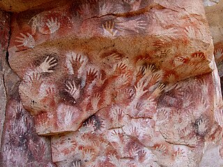
In archaeology, cave paintings are a type of parietal art, found on the wall or ceilings of caves. The term usually implies prehistoric origin, and the oldest known are more than 40,000 years old and found in the caves in the district of Maros. The oldest are often constructed from hand stencils and simple geometric shapes. More recently, in 2021, cave art of a pig found in Sulawesi, Indonesia, and dated to over 45,500 years ago, has been reported.

Baja California Sur, officially Estado Libre y Soberano de Baja California Sur, is the least populated state and the 31st admitted state of the 32 federal entities which comprise the 31 States of Mexico. It is also the ninth-largest Mexican state in terms of area.
Bahía de los Ángeles is a coastal bay on the Gulf of California, located along the eastern shore of the Baja California Peninsula in the state of Baja California, Mexico. The town of the same name is located at the east end of Federal Highway 12 about 42 miles (68 km) from the Parador Punta Prieta junction on Federal Highway 1. The area is part of the San Quintín Municipality.

In archaeology, rock art is human-made markings placed on natural surfaces, typically vertical stone surfaces. A high proportion of surviving historic and prehistoric rock art is found in caves or partly enclosed rock shelters; this type also may be called cave art or parietal art. A global phenomenon, rock art is found in many culturally diverse regions of the world. It has been produced in many contexts throughout human history. In terms of technique, the four main groups are:

The Sierra de Guadalupe cave paintings are a series of prehistoric rock art pictographs near Rancho La Trinidad, Mulegé in Baja California Sur, Mexico. The Sierra de Guadalupe, mountains west of Mulegé, contains the largest number of known prehistoric rock art sites in Baja California.
Sigismundo Taraval (1700–1763) was a pioneering Jesuit missionary in Baja California who wrote important historical accounts of the peninsula.
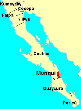
The Monqui were indigenous peoples of Mexico, who lived in the vicinity of Loreto, Baja California Sur, Mexico, at the time of Spanish contact. Monqui territory included about 65 kilometres (40 mi) of coast along the Gulf of California and extended a few kilometers inland to where the Cochimi people lived.

The Cochimí were the indigenous inhabitants of the central part of the Baja California peninsula, from El Rosario in the north to San Javier in the south. Information on Cochimí customs and beliefs has been preserved in the brief observations by explorers but, above all, in the writings of the Jesuits. Particularly important and detailed are the works of Miguel Venegas and Miguel del Barco (1973).
Wenceslaus Linck was the last of the outstanding Jesuit missionary-explorers in Baja California.
The Comondú Complex is an archaeological pattern dating from the late prehistoric period in northern Baja California Sur and southern Baja California. It is associated with the historic Cochimí people of the peninsula.

The Rock Paintings of Sierra de San Francisco are prehistoric rock art pictographs found in the Sierra de San Francisco mountain range in Mulegé Municipality of the northern region of Baja California Sur state, in Mexico.
Harry W. Crosby is an American historian and photographer. His parents moved to La Jolla in 1935. He graduated from La Jolla High School in 1944, and studied math and science at Occidental College in Los Angeles, completing a double major in pre-med and psychology. After twelve years as a teacher of secondary-level science, mostly chemistry, he took up photography, and in 1967, was hired as a photographer to illustrate the book The Call to California for the Commission of the Californias, commemorating California's bicentennial. Following the route of the Portolá expedition of 1769 to make photos to illustrate a text derived from diaries of the trekkers, Crosby rode 600 miles on muleback on remote trails. Since then, he has continued to do primary research and to write extensively on the history and cave paintings of Baja California and the early history of Alta California.
The Sierra de San Francisco is a mountain range in Mulegé Municipality of the northern region of Baja California Sur state, in northwestern Mexico.
Kiliwa, alternate Names: Kiliwi, Ko’lew or Quiligua is a Yuman language spoken in Baja California, in the far northwest of Mexico, by the Kiliwa people.

El Vallecito is an archaeological site located in the city of La Rumorosa, in the Tecate Municipality, Baja California, Mexico.

Léon Diguet was a French naturalist.
José Mariano Rotea (1732–1799) was a Jesuit missionary on the Baja California peninsula who played a key role in the rediscovery of the peninsula's prehistoric Great Murals rock art.
The Sierra de San Borja, also known as Sierra La Libertad is a mountain range on the Baja California Peninsula of Mexico. It is one of the Peninsular Ranges which form the backbone of Baja California. The Sierra de San Borja is located between 28° North latitude and 29° North latitude. The highest point of the Sierra is Cerro La Sandia, 1,775 metres (5,823 ft) in elevation located at 28°24′25″N113°26′18″W.
Harumi Fujita is a Japanese researcher of Mexican archaeology, who has specialized in pre-classical period of the northern states of Baja California and Baja California Sur. Her research has shown that fishing cultures had arisen in the area at the end of the Pleistocene period, indicating an occupation from at least 11,000 years ago. In a cave shelf known as the Babisuri Shelter, radiocarbon dating indicated the area may have been occupied 40,000 years ago.