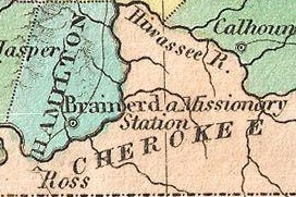
The Trail of Tears was an ethnic cleansing and forced displacement of approximately 60,000 people of the "Five Civilized Tribes" between 1830 and 1850 by the United States government. As part of the Indian removal, members of the Cherokee, Muscogee (Creek), Seminole, Chickasaw, and Choctaw nations were forcibly removed from their ancestral homelands in the Southeastern United States to newly designated Indian Territory west of the Mississippi River after the passage of the Indian Removal Act in 1830. The Cherokee removal in 1838 was brought on by the discovery of gold near Dahlonega, Georgia, in 1828, resulting in the Georgia Gold Rush.

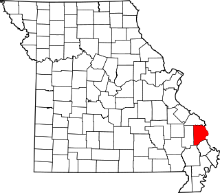
Cape Girardeau County is located in the southeastern part of the U.S. state of Missouri; its eastern border is formed by the Mississippi River. At the 2020 census, the population was 81,710. The county seat is Jackson, the first city in the US to be named in honor of President Andrew Jackson. Officially organized on October 1, 1812, the county is named after Ensign Sieur Jean Baptiste de Girardot, an official of the French colonial years. The "cape" in the county's name is named after a former promontory rock overlooking the Mississippi River; this feature was demolished during railroad construction. Cape Girardeau County is the hub of the Cape Girardeau–Jackson metropolitan area. Its largest city is Cape Girardeau.

Calhoun County is a county in the U.S. state of Illinois. As of the 2020 census, the population was 4,437, making it Illinois’ third-least populous county. Its county seat and biggest community is Hardin, with a population of 801. Its smallest incorporated community is Hamburg, with a population of 99. Calhoun County is at the tip of the peninsula formed by the courses of the Mississippi and Illinois rivers above their confluence and is almost completely surrounded by water. Calhoun County is sparsely populated; it has just five municipalities, all of them villages.

Cape Girardeau is a city in Cape Girardeau and Scott Counties in the U.S. state of Missouri. At the 2020 census, the population was 39,540. The city is one of two principal cities of the Cape Girardeau-Jackson, MO-IL Metropolitan Statistical Area, which encompasses Alexander County, Illinois, Bollinger County, Missouri and Cape Girardeau County, Missouri and has a population of 97,517. The city is the economic center of Southeast Missouri and also the home of Southeast Missouri State University. It is located approximately 100 miles (161 km) southeast of St. Louis and 150 miles (241 km) north of Memphis.

Southern Illinois, also known as Little Egypt, is a region of the U.S. state of Illinois comprising the southern third of the state, principally along and south of Interstate 64. Part of downstate Illinois, it is bordered by the two most voluminous rivers in the United States: the Mississippi below its connecting Missouri River to the west and the Ohio River to the east and south, with the Wabash as a tributary.
There are many historic trails and roads in the United States which were important to the settlement and development of the United States including those used by American Indians.

Fort Smith National Historic Site is a National Historic Site located in Fort Smith, Arkansas, along the Arkansas River. The first fort at this site was established by the United States in 1817, before this area was established as part of Indian Territory. It was later replaced and the second fort was operated by the US until 1871. This site was designated as a National Historic Landmark in 1961.

The Chief Vann House is the first brick residence in the Cherokee Nation, and has been called the "Showplace of the Cherokee Nation". Owned by the Cherokee Chief James Vann, the Vann House is a Georgia Historic Site on the National Register of Historic Places and one of the oldest remaining structures in the northern third of the state of Georgia. It is located in Murray County, on the outskirts of Chatsworth in northwest Georgia, which has a commanding view of the land around it and of the Cohutta Mountains, about 10 miles (16 km) to the east.
Trail of Tears State Park is a public recreation area covering 3,415 acres (1,382 ha) bordering the Mississippi River in Cape Girardeau County, Missouri. The state park stands as a memorial to those Cherokee Native Americans who died on the Cherokee Trail of Tears. The park's interpretive center features exhibits about the Trail of Tears as well as displays and specimens of local wildlife. An archaeological site in the park was added to the National Register of Historic Places in 1970.

Blythe Ferry was a ferry across the Tennessee River in Meigs County, Tennessee, United States. In 1838, the ferry served as a gathering point and crossing for the Cherokee Removal, commonly called the Trail of Tears, in which thousands of Cherokee were forced to move west to Oklahoma from their homeland in the southeastern United States.
Jesse Bushyhead was a Cherokee religious and political leader, and a Baptist minister. He was born near the present-day town of Cleveland, Tennessee. As a young man, he was ordained a Baptist minister.
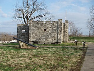
Fort D is a Civil War-era fort alongside the Mississippi River in Cape Girardeau, Missouri, USA.

The Old Lorimier Cemetery in Cape Girardeau, Missouri was established between 1806 and 1808 by Louis Lorimier. The cemetery is located at 500 North Fountain Street overlooking the Mississippi River. There are believed to be more than 6,500 graves in the cemetery, most of them unmarked. A sidewalk serves as a north – south dividing line in the cemetery. It is said that Catholics are buried on the south and Protestants are buried on the north. The east slope is believed to be the burial grounds of African-American persons. It has been recorded that as many as 1,200 soldiers from the Civil War were buried there. The grave marker for the wife of Louis Lorimier says "The Noblest Matron of the Shawnee race."

The Blair's Ferry Storehouse is a historic brick structure in the U.S. city of Loudon, Tennessee. Originally built as a storehouse for the burgeoning riverboat trade in the community of Blair's Ferry in the 1830s, the structure was eventually renovated and used for a variety of functions throughout the 19th and 20th centuries. The building is one of the region's earliest surviving examples of a structure designed specifically as a warehouse. In 1977, the building was placed on the National Register of Historic Places.

Ross's Landing in Chattanooga, Tennessee, is the last site of the Cherokee's 61-year occupation of Chattanooga and is considered to be the embarkation point of the Cherokee removal on the Trail of Tears. Ross's Landing Riverfront Park memorializes the location, which is listed on the National Register of Historic Places.
Cherokee removal, part of the Trail of Tears, refers to the forced relocation between 1836 and 1839 of an estimated 16,000 members of the Cherokee Nation and 1,000–2,000 of their slaves; from their lands in Georgia, South Carolina, North Carolina, Tennessee, and Alabama to the Indian Territory in the then Western United States, and the resultant deaths along the way and at the end of the movement of an estimated 4,000 Cherokee and unknown number of slaves, although no records of these deaths have ever materialized. Many scholars believe these Indians absconded from the removal rather than died.
Neely's Landing or Neelys Landing is an unincorporated community in Shawnee Township in northern Cape Girardeau County, Missouri, United States. It is located seventeen miles north of Cape Girardeau and is part of the Cape Girardeau–Jackson, MO-IL Metropolitan Statistical Area.
Hines Landing is an unincorporated community in Cape Girardeau County, in the U.S. state of Missouri.
Bainbridge Ferry, also known as the Randol's Ferry and Littleton's Ferry, is a historic ferry landing on the western shore of the Mississippi River at Cape Girardeau, Missouri. It is the site of a ferry that was established about 1805 and operated in the 19th century. The ferry was located at one of two places on the Mississippi River utilized by the Cherokee to cross from Illinois to Missouri on the Trail of Tears of 1837–1839.

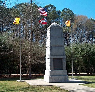
Cherokee Removal Memorial Park is a public park in Meigs County, Tennessee that is dedicated in memory of the Cherokee who were forced to emigrate from their ancestral lands during the Cherokee removal, in an event that came to be known as the Trail of Tears. It was established in 2005, and has since expanded.


