Green Isle | |
---|---|
Motto: "A Bit Of Ireland" [1] | |
Coordinates: 44°40′49″N94°00′19″W / 44.68028°N 94.00528°W | |
Country | United States |
State | Minnesota |
County | Sibley |
Government | |
• Type | Mayor – Council |
• Mayor | Shane Sheets [2] |
Area | |
• Total | 1.02 sq mi (2.65 km2) |
• Land | 1.01 sq mi (2.63 km2) |
• Water | 0.01 sq mi (0.02 km2) |
Elevation | 991 ft (302 m) |
Population (2020) | |
• Total | 522 |
• Density | 582.27/sq mi (224.77/km2) |
Time zone | UTC-6 (Central (CST)) |
• Summer (DST) | UTC-5 (CDT) |
ZIP code | 55338 |
Area code | 507 |
FIPS code | 27-25658 |
GNIS feature ID | 2394976 [4] |
Website | www.greenislemn.gov |
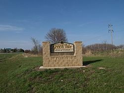
Green Isle is a city in Sibley County, Minnesota, United States. The population was 522 at the 2020 census. [5]
The Minneapolis and St. Louis Railway (M&StL) originally built the railroad tracks between Norwood and Morton circa 1880. Green Isle was platted in 1881, incorporating these northeast/southwest-oriented tracks. The town was named after the previously existing township, its name alluding to Ireland, the Emerald Isle, as many of its earliest settlers were from Ireland. [6]
According to the United States Census Bureau, the city has an area of 0.98 square miles (2.54 km2), all land. [7] Minnesota State Highways 5 and 25 are two of the main routes in the community.
The city operates under a mayor/council system with Shane Sheets serving as mayor since January 2023. [8]
Census | Pop. | Note | %± |
---|---|---|---|
1890 | 219 | — | |
1900 | 275 | 25.6% | |
1910 | 256 | −6.9% | |
1920 | 262 | 2.3% | |
1930 | 300 | 14.5% | |
1940 | 376 | 25.3% | |
1950 | 332 | −11.7% | |
1960 | 331 | −0.3% | |
1970 | 363 | 9.7% | |
1980 | 357 | −1.7% | |
1990 | 239 | −33.1% | |
2000 | 334 | 39.7% | |
2010 | 559 | 67.4% | |
2020 | 522 | −6.6% | |
U.S. Decennial Census; [5] |
As of the census of 2010, there were 559 people, 218 households, and 154 families residing in the city. The population density was 570.4 inhabitants per square mile (220.2/km2). There were 240 housing units at an average density of 244.9 per square mile (94.6/km2). The racial makeup of the city was 98.2% White, 0.4% African American, 0.2% Native American, 0.9% from other races, and 0.4% from two or more races. Hispanic or Latino of any race were 3.0% of the population.
There were 218 households, of which 39.9% had children under 18 living with them, 51.8% were married couples living together, 11.5% had a female householder with no husband present, 7.3% had a male householder with no wife present, and 29.4% were non-families. 22.9% of all households were made up of individuals, and 6.4% had someone living alone who 65 or older. The average household size was 2.56 and the average family size was 2.98.
The median age in the city was 32.1. 30.2% of residents were under 18; 5.1% were between 18 and 24; 36.9% were from 25 to 44; 16% were from 45 to 64; and 12% were 65 or older. The gender makeup of the city was 48.8% male and 51.2% female.
As of the census of 2000, there were 334 people, 136 households, and 102 families residing in the city. The population density was 447.5 inhabitants per square mile (172.8/km2). There were 141 housing units at an average density of 188.9 per square mile (72.9/km2). The racial makeup of the city was 98.50% White, 0.30% African American, 0.90% Asian, 0.30% from other races. Hispanic or Latino of any race were 3.59% of the population.
There were 136 households, of which 33.1% had children under 18 living with them, 65.4% were married couples living together, 5.9% had a female householder with no husband present, and 25.0% were non-families. 22.8% of all households were made up of individuals, and 11.0% had someone living alone who was 65 or older. The average household size was 2.46 and the average family size was 2.89.
In the city, the population was spread out, with 24.9% under 18, 7.5% from 18 to 24, 32.6% from 25 to 44, 18.3% from 45 to 64, and 16.8% who were 65 or older. The median age was 36. For every 100 females, there were 108.8 males. For every 100 females 18 and over, there were 110.9 males.
The median income for a household in the city was $44,792, and the median income for a family was $51,964. Males had a median income of $31,979 versus $25,625 for females. The per capita income was $25,537. About 1.8% of families and 2.5% of the population were below the poverty line, including none of those under 18 and 11.8% of those 65 or over.
McGregor is a city in Aitkin County, Minnesota, United States. The population was 391 at the 2010 census. McGregor is along Minnesota State Highways 65 and 210. Other routes include Aitkin County Road 8.
Kelliher is a city in Beltrami County, Minnesota, United States. The population was 258 at the 2020 census. Minnesota State Highway 72 is the primary route through Kelliher.
Watertown is a small city in Carver County, Minnesota, United States, along the South Fork of the Crow River, on the outskirts of the Twin Cities metro area. The population was 4,659 at the 2020 census.
Hitterdal is a city in Clay County, Minnesota, United States. The population was 199 at the 2020 census.
Garfield is a city in Douglas County, Minnesota, United States. The population was 349 at the 2020 census.
Greenwood is a community on Saint Albans Bay on Lake Minnetonka in Hennepin County, Minnesota, United States just northeast of the community of Excelsior, Minnesota. The population was 688 at the 2010 census.
Spicer is a city in Kandiyohi County, Minnesota, United States situated on Green Lake. The population was 1,167 at the 2010 census. Sibley State Park and many surrounding lakes are nearby.
Lancaster is a city in Kittson County, Minnesota, United States. As of the 2020 census, the city population was 364.
Isle is a city in Mille Lacs County, Minnesota, United States. The population was 803 at the 2020 census, up from 751 in 2010.
Wahkon is a city in Mille Lacs County, Minnesota, United States. The population was 235 as of the 2020 census, up from 206 in 2010.
Deer Creek is a city in Otter Tail County, Minnesota, United States. The population was 330 at the 2020 census.
Ottertail is a city in Otter Tail County, Minnesota, United States. The population was 629 at the 2020 census.
Urbank is a city in Otter Tail County, Minnesota, United States. The population was 52 at the 2020 census.
Nielsville is a city in Polk County, Minnesota, United States. It is part of the Grand Forks, ND-MN Metropolitan Statistical Area. The population was 78 at the 2020 census.
Green Isle Township is a township in Sibley County, Minnesota, United States. The population was 556 at the 2000 census.
McKinley is a city in Saint Louis County, Minnesota, United States; located within the Iron Range region of Minnesota. The population was 103 at the 2020 census.
Winton is a city in Saint Louis County, Minnesota, United States. The population was 169 at the 2020 census. The city is home to a small hydroelectric dam on the edge of Garden Lake, one of 11 stations owned by Minnesota Power.
Federal Dam is a city in Cass County, Minnesota, United States, near Leech Lake. The population was 123 at the 2020 census. It is part of the Brainerd Micropolitan Statistical Area.
St. Anthony or Saint Anthony is a city in Stearns County, Minnesota, United States. The population was 91 at the 2020 census. It is part of the St. Cloud Metropolitan Statistical Area. Main routes include Minnesota State Highway 238, Stearns County Road 153, and Trobec Street.
Minnesota Lake is a city in Blue Earth and Faribault counties in the State of Minnesota. The population was 661 at the 2020 census. The bulk of the city is in Faribault County; a small part extends into Blue Earth County.