Winthrop, Minnesota

Last updated

Winthrop
Motto(s): 
"Preserving The Past, Creating The Future"
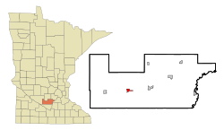
Sibley County Minnesota Incorporated and Unincorporated areas Winthrop Highlighted.svg
Location of Winthrop
within Sibley County, Minnesota
Coordinates: 44°32′32″N94°21′36″W / 44.54222°N 94.36000°W / 44.54222; -94.36000
Country United States
State Minnesota
County Sibley
Government
  TypeMayor Council
  MayorRobert Edwards [ citation needed ]
Area
[1]
  Total1.27 sq mi (3.30 km2)
  Land1.27 sq mi (3.30 km2)
  Water0.00 sq mi (0.00 km2)
Elevation
[2]
1,007 ft (307 m)
Population
 (2020)
  Total1,332
  Density1,044.71/sq mi (403.24/km2)
Time zone UTC-6 (Central (CST))
  Summer (DST) UTC-5 (CDT)
ZIP code
55396
Area code 507
FIPS code 27-71122 [3]
GNIS feature ID2397352 [2]
Website www.winthropminnesota.com

Winthrop is a city in Sibley County, Minnesota, United States. The population was 1,399 at the 2010 census. [4]

Contents

History

A post office called Winthrop has been in operation since 1882. [5] Winthrop was incorporated as a city in 1910. [6]

Geography

According to the United States Census Bureau, the city has a total area of 1.06 square miles (2.75 km2), all land. [7] The South Branch of the Rush River starts near Winthrop. [8]

Minnesota State Highways 15 and 19 are two of the main routes in the city.

Demographics

Historical population
CensusPop.Note
1890 488
1900 81366.6%
1910 1,04828.9%
1920 1,1479.4%
1930 1,037−9.6%
1940 1,19515.2%
1950 1,2514.7%
1960 1,38110.4%
1970 1,3910.7%
1980 1,376−1.1%
1990 1,279−7.0%
2000 1,3676.9%
2010 1,3992.3%
2020 1,332−4.8%
U.S. Decennial Census

2010 census

At the 2010 census, [9] there were 1,399 people, 574 households and 355 families living in the city. The population density was 1,319.8 per square mile (509.6/km2). There were 640 housing units at an average density of 603.8 per square mile (233.1/km2). The racial make-up was 93.4% White, 0.5% African American, 0.7% Native American, 0.5% Asian, 3.9% from other races, and 1.1% from two or more races. Hispanic or Latino of any race were 7.4% of the population.

There were 574 households, of which 28.0% had children under the age of 18 living with them, 48.6% were married couples living together, 8.7% had a female householder with no husband present, 4.5% had a male householder with no wife present and 38.2% were non-families. 33.8% of all households were made up of individuals, and 18.8% had someone living alone who was 65 years of age or older. The average household size was 2.36 and the average family size was 2.97.

The median age was 41.7 years. 25.9% of residents were under the age of 18; 5.1% were between the ages of 18 and 24; 21.7% were from 25 to 44; 25.3% were from 45 to 64; and 22% were 65 years of age or older. The gender make-up was 47.7% male and 52.3% female.

2000 census

At the 2000 census, [8] there were 1,367 people, 591 households and 346 families living in the city. The population density was 1,303.8 per square mile (503.4/km2). There were 632 housing units at an average density of 602.8 per square mile (232.7/km2). The racial make-up was 93.71% White, 0.07% African American, 0.29% Native American, 0.15% Asian, 4.54% from other races and 1.24% from two or more races. Hispanic or Latino of any race were 6.95% of the population.

There were 591 households, of which 26.1% had children under the age of 18 living with them, 48.7% were married couples living together, 6.8% had a female householder with no husband present,and 41.3% were non-families. 38.7% of all households were made up of individuals, and 21.5% had someone living alone who was 65 years of age or older. The average household size was 2.22 and the average family size was 2.96.

23.7% of the population were under the age of 18, 6.1% from 18 to 24, 23.3% from 25 to 44, 21.2% from 45 to 64, and 25.6% were 65 years of age or older. The median age was 43 years. For every 100 females, there were 88.3 males. For every 100 females age 18 and over, there were 83.6 males.

The median household income was $34,813 and the median family income was $47,159. Males had a median income of $31,149 and females $20,573. The per capita income was $18,188. About 3.5% of families and 6.1% of the population were below the poverty line, including 5.7% of those under age 18 and 8.2% of those age 65 or over.

Education

Winthrop is the site of ISD #2365's high school.

Related Research Articles

<span class="mw-page-title-main">Winthrop, Iowa</span> City in Iowa, United States

Winthrop is a city in Buchanan County, Iowa, United States. The population was 823 at the time of the 2020 census.

<span class="mw-page-title-main">Mount Vernon, Maine</span> Town in the state of Maine, United States

Mount Vernon is a town in Kennebec County, Maine, United States. The population was 1,721 at the 2020 census. Mount Vernon is included in the Augusta, Maine micropolitan New England City and Town Area. A popular recreation spot in central Maine, the northern area of Mount Vernon is part of the Belgrade Lakes Region, while the southern area is part of the Winthrop Lakes Region.

<span class="mw-page-title-main">Ramsey, Minnesota</span> City in Minnesota, United States

Ramsey is a suburb 22 miles north-northwest of downtown Minneapolis in Anoka County, Minnesota, United States. The population was 27,646 at the 2020 census. It is a northwest suburb of the Twin Cities.

<span class="mw-page-title-main">Hampton, Minnesota</span> City in Minnesota, United States

Hampton is a city in Dakota County, Minnesota, United States. The population was 689 at the 2010 census.

Verona Township is a township in Faribault County, Minnesota, United States. The population was 391 at the 2000 census.

<span class="mw-page-title-main">Wanamingo, Minnesota</span> City in Minnesota, United States

Wanamingo is a community in Goodhue County, Minnesota, United States, incorporated as a city. It lies along the North Fork of the Zumbro River. The population was 1,086 at the 2010 census.

<span class="mw-page-title-main">Isanti, Minnesota</span> City in Minnesota, United States

Isanti is a city in Isanti County, Minnesota, United States. The population was 6,804 at the 2020 census. The name Isanti is composed of two Dakota words: isan ("knife") and ati ("camp"), and refers to the Santee Dakota people.

<span class="mw-page-title-main">Coleraine, Minnesota</span> City in Minnesota, United States

Coleraine is a city in Itasca County, Minnesota, United States. The population was 1,970 at the 2010 census. The community was named after Thomas F. Cole, President of the Oliver Iron Mining Company.

<span class="mw-page-title-main">Stephen, Minnesota</span> City in Minnesota, United States

Stephen is a city in Marshall County, Minnesota, United States. The population was 592 at the 2020 census.

<span class="mw-page-title-main">Bluffton, Minnesota</span> City in Minnesota, United States

Bluffton is a city in Otter Tail County, Minnesota, United States, along the Leaf River. The population was 210 at the 2020 census.

<span class="mw-page-title-main">Deer Creek, Minnesota</span> City in Minnesota, United States

Deer Creek is a city in Otter Tail County, Minnesota, United States. The population was 330 at the 2020 census.

<span class="mw-page-title-main">Henning, Minnesota</span> City in Minnesota, United States

Henning is a city in Otter Tail County, Minnesota, United States. The population was 854 at the 2020 census.

<span class="mw-page-title-main">Maplewood, Minnesota</span> City in Minnesota, United States

Maplewood is a city in Ramsey County, Minnesota, United States. The population was 42,088 at the 2020 census. Maplewood is ten minutes' drive from downtown Saint Paul. It stretches along the northern and eastern borders of Saint Paul.

<span class="mw-page-title-main">Mountain Iron, Minnesota</span> City in Minnesota, United States

Mountain Iron is a city in Saint Louis County, Minnesota, United States, in the heart of the Mesabi Range. The population was 2,878 at the 2020 census.

<span class="mw-page-title-main">Orr, Minnesota</span> City in Minnesota, United States

Orr is a city in Saint Louis County, Minnesota, United States. The population was 211 at the 2020 census.

<span class="mw-page-title-main">Grant, Minnesota</span> City in Minnesota, United States

Grant is a city in Washington County, Minnesota, and a suburb of St. Paul. The population was 4,096 at the time of the 2010 census.

<span class="mw-page-title-main">Minnesota Lake, Minnesota</span> City in Minnesota, United States

Minnesota Lake is a city in Blue Earth and Faribault counties in the State of Minnesota. The population was 661 at the 2020 census. The bulk of the city is in Faribault County; a small part extends into Blue Earth County.

<span class="mw-page-title-main">Motley, Minnesota</span> City in Minnesota, United States

Motley is a city in Cass and Morrison counties in the U.S. state of Minnesota. The population was 680 at the 2020 census. The main part of Motley is located within Morrison County; only a minor part of the city extends into Cass County

<span class="mw-page-title-main">Ormsby, Minnesota</span> City in Minnesota, United States

Ormsby is a city in Martin and Watonwan counties in the U.S. state of Minnesota. The population was 131 at the 2010 census.

<span class="mw-page-title-main">Brooten, Minnesota</span> City in Minnesota, United States

Brooten is a city in Stearns and Pope counties in the U.S. state of Minnesota, United States. The population was 626 as of the 2020 census. Almost the entire city is within Stearns County, with a small portion in Pope County.

References

  1. "2020 U.S. Gazetteer Files". United States Census Bureau. Retrieved July 24, 2022.
  2. 1 2 U.S. Geological Survey Geographic Names Information System: Winthrop, Minnesota
  3. "U.S. Census website". United States Census Bureau . Retrieved January 31, 2008.
  4. "2010 Census Redistricting Data (Public Law 94-171) Summary File". American FactFinder. United States Census Bureau . Retrieved April 27, 2011.[ dead link ]
  5. "Sibley County". Jim Forte Postal History. Retrieved August 8, 2015.
  6. Upham, Warren (1920). Minnesota Geographic Names: Their Origin and Historic Significance. Minnesota Historical Society. p.  520.
  7. "US Gazetteer files 2010". United States Census Bureau . Retrieved November 13, 2012.
  8. 1 2 U.S. Census Bureau, 2000 Census data Archived 2020-02-12 at archive.today .
  9. "U.S. Census website". United States Census Bureau . Retrieved November 13, 2012.