
The Shire of Plantagenet is a local government area in the Great Southern region of Western Australia, managed from the town of Mount Barker, 360 kilometres (224 mi) south of Perth and 50 kilometres (31 mi) north of Albany. The shire covers an area of 4,792 square kilometres (1,850 sq mi) and includes the communities of Narrikup, Rocky Gully, Kendenup and Porongurup.
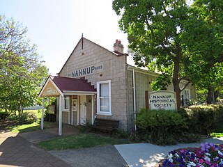
The Shire of Nannup is a local government area in the South West region of Western Australia, approximately 280 kilometres (174 mi) south of the state capital, Perth and 60 kilometres (37 mi) southeast of the coastal resort town of Busselton. Its seat of government is the town of Nannup, where about half of the Shire's population reside.

The Shire of Kojonup is a local government area in the Great Southern region of Western Australia, about 250 kilometres (155 mi) southeast of the state capital, Perth, along Albany Highway. The Shire covers an area of 2,932 square kilometres (1,132 sq mi) and its seat of government is the town of Kojonup.
The Shire of Gnowangerup is a local government area in the Great Southern region of Western Australia, about 120 kilometres (75 mi) north of Albany and about 370 kilometres (230 mi) southeast of the capital, Perth. The Shire covers an area of 4,268 square kilometres (1,648 sq mi), and its seat of government is the town of Gnowangerup.

The Shire of Cranbrook is a local government area in the Great Southern region of Western Australia, about 92 kilometres (57 mi) north of Albany and about 320 kilometres (200 mi) south-southeast of the state capital, Perth. The Shire covers an area of 3,277 square kilometres (1,265 sq mi), and its seat of government is the town of Cranbrook.

The Shire of Exmouth is a local government area in the Gascoyne region of Western Australia, about 1,000 kilometres (600 mi) north of the state capital, Perth. The Shire covers an area of 6,503 square kilometres (2,511 sq mi), and its seat of government is the town of Exmouth.

The Shire of Jerramungup is a local government area in the Great Southern region of Western Australia, about 180 kilometres (112 mi) northeast of Albany and about 440 kilometres (273 mi) southeast of the state capital, Perth. The Shire covers an area of 6,507 square kilometres (2,512 sq mi) with Bremer Bay its largest town. The seat of government is the town of Jerramungup.

The Shire of Katanning is a local government area in the Great Southern region of Western Australia, about 170 kilometres (106 mi) north of Albany and about 290 kilometres (180 mi) southeast of the state capital, Perth. The Shire covers an area of 1,518 square kilometres (586 sq mi), and its seat of government is the town of Katanning.

The Shire of Woodanilling is a local government area in the Great Southern region of Western Australia, about 30 kilometres (19 mi) south of Wagin and about 260 kilometres (162 mi) south-southeast of the state capital, Perth. The Shire covers an area of 1,129 square kilometres (436 sq mi), and its seat of government is the town of Woodanilling.
The Shire of Broomehill-Tambellup is a local government area in the Great Southern region of Western Australia, 320 kilometres (200 mi) south-southeast of the state capital, Perth. The Shire covers an area of 2,609.1 square kilometres (1,007.4 sq mi), and its seat of government is the town of Tambellup. It came into existence in 2008 through the amalgamation of the former Shire of Broomehill and Shire of Tambellup.
Goode Beach is a locality of the City of Albany in the Great Southern region of Western Australia. It borders the Torndirrup National Park to the south.. It is located about 7.4 km (4.6 mi) from Albany on the other side of the bay.
Big Grove is a locality of the City of Albany in the Great Southern region of Western Australia. It is located approximately 4.8 km (3.0 mi) from Albany across the bay.
Drome is a locality in the Great Southern Region of Western Australia. Albany Airport is located in the south-east of Drome. It is located 14.7 km (9.1 mi) from Albany on the Albany Highway and it is within the City of Albany local government area. The site is in the traditional settlement area of the Mineng Aboriginal tribe. At the 2021 census, Drome recorded a population of 52.

Cheynes is a locality of the City of Albany in the Great Southern region of Western Australia. The entirety of Waychinicup National Park is located within Cheynes. It is located 59.5 km (37.0 mi) from Albany.
Gnowellen is a locality of the City of Albany in the Great Southern region of Western Australia. It borders the Stirling Range National Park in the west.
Cuthbert is a town and locality of the City of Albany in the Great Southern region of Western Australia. Cuthbert is about 8 km (5.0 mi) west of the Albany city center.
Kojaneerup South is a locality of the City of Albany in the Great Southern region of Western Australia. A small section of the Stirling Range National Park is located within Kojaneerup South.
Green Valley is a locality of the City of Albany in the Great Southern region of Western Australia. The Albany Highway formes the western border of the locality.
Kronkup is a locality of the City of Albany in the Great Southern region of Western Australia. It stretches from the South Coast Highway, on its northern border, to the Southern Ocean in the south.
Hay is a locality in the Shire of Denmark, Great Southern region of Western Australia.

