
Pineridge is a neighbourhood in Northeast Calgary, Alberta, Canada, and is one of four neighbourhoods that make up what is called the Properties, along with Whitehorn, Temple, and Rundle. It is bordered by 32 Ave NE to the north, 52nd Street NE to the west, 16th Avenue NE to the south, and 68th Street NE to the east.
University Heights is a residential neighbourhood in the northwest quadrant of Calgary, Alberta, Canada. It is located south of the University of Calgary, McMahon Stadium, the Alberta Children's Hospital and Foothills Hospital. It is a relatively small neighbourhood and is bounded to the north by 24 Avenue N, to the east by University Drive, to the south by 16 Avenue N and to the west by Shaganappi Trail.
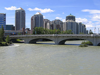
The Downtown West End is a neighbourhood within the western portions of downtown Calgary, Alberta, Canada. It is bounded to the north by the Bow River, to the east by 9th Street W, to the south by the CPR Tracks and to the west by 14th Street W.
Crescent Heights is a neighbourhood located in Calgary, Alberta. It is located in the inner city, immediately north from Downtown. It is bounded to the north by the Trans-Canada Highway, on the east by Edmonton Trail, on the west by 4th Street NW, and to the south by Memorial Drive and the Bow River.
Valley Ridge is a residential neighbourhood in the northwest quadrant of Calgary, Alberta, Canada. It is located at the western edge of the city, south of the Bow River and north of the Trans-Canada Highway. The Valley Ridge golf course is located in the northern part of the community. The community is located on the former site of the Happy Valley Campground a fun park with slides, which was a major destination for visitors to Calgary until it was closed in the 1980s; the campground was located where the golf course is now situated.
Banff Trail is a residential neighbourhood in the northwest quadrant of Calgary, Alberta. It is located northeast of the intersection of Crowchild Trail and Trans-Canada Highway, east of McMahon Stadium and the University of Calgary. The Banff Trail station of the C-train LRT system serves the community, which contains a large motel village in the southwest corner.
Renfrew is a residential neighbourhood in the northeast quadrant of Calgary, Alberta. It is located south of the Trans-Canada Highway, and north of the inner city community of Bridgeland. To the east it is bordered by the Nose Hill Creek and the Deerfoot Trail and is separated from Crescent Heights to the west by Edmonton Trail.
Rosedale is a residential neighbourhood in the northwest quadrant of Calgary, Alberta. It is located south of the Trans-Canada Highway, between 4th and 10th Street NW. To the south it is bounded by McHugh Bluff Park and the community of Sunnyside.
Mount Pleasant is a residential neighbourhood in the northwest quadrant of Calgary, Alberta. It is located immediately north from the Trans-Canada Highway and the community of Rosedale. To the north and west it is bounded by the Confederation Park.
Winston Heights/Mountview is a residential neighbourhood in the northeast quadrant of Calgary, Alberta. It is bounded by 32 Avenue to the north, the Nose Creek and Deerfoot Trail to the east, Trans-Canada Highway to the south and Edmonton Trail to the west. Fox Hollow Golf Course and The Winston Golf Club are developed at the eastern edge of the neighbourhood.
Capitol Hill is a residential neighbourhood in the northwest quadrant of Calgary, Alberta, Canada. It is located immediately north of the Trans-Canada Highway, and is bisected by 14th Street West. The Southern Alberta Institute of Technology and the North Hill shopping center are located south of the community. To the north it is bounded by the Confederation Park.
Tuxedo Park is a residential neighbourhood in the northeast and northwest quadrants of Calgary, Alberta. The inner city community is bounded to the north by 32 Avenue N, by Edmonton Trail to the east, the Trans-Canada Highway to the south and 2 Street NW to the west. The community is bisected by Centre Street from north to south.
Vista Heights is a residential neighbourhood in the northeast quadrant of Calgary, Alberta. It is bounded to the south by the Trans-Canada Highway and to the west by Deerfoot Trail. To the north and east it borders the South Airways Industrial Area.
Strathcona Park is a residential neighbourhood in the southwest quadrant of Calgary, Alberta. It is bounded by Bow Trail to the north, Sarcee Trail to the east, Strathcona Drive and the community of Christie Park to the south and Strathcona Park Blvd to the west. Strathcona Park lies in the center of the neighbourhood.
Marlborough Park is a residential neighbourhood in the northeast quadrant of Calgary, Alberta. It is bounded by 68 Street E to the east, 52 Street E to the west, Trans-Canada Highway to the north and Memorial Drive to the south. The homonymous park is located at the center of the community.
Rundle is a residential neighbourhood in the northeast quadrant of Calgary, Alberta. It is bounded by 32 Avenue NE to the north, 16 Avenue NE to the south, 52 Street NE to the east and 36 Street NE to the west. The Sunridge Mall is located immediately west of the neighbourhood. Rundle is home to a large Lebanese group.
Mayland Heights is a residential neighbourhood in the northeast quadrant of Calgary, Alberta. It is bounded by Barlow Trail to the east, Memorial Drive to the south, Deerfoot Trail to the west and Trans-Canada Highway to the north.

St. Andrews Heights is a residential neighbourhood in the northwest quadrant of Calgary, Alberta. It is bounded to the north by the Trans-Canada Highway, to the east by Crowchild Trail, to the south by Toronto Crescent, and to the west by 29 Street. The Foothills Medical Centre occupies the northwestern corner of the community, and McMahon Stadium and the Foothills Athletic Park borders to the northeast. The Bow River flows immediately south of the neighbourhood.
Parkland is a residential neighbourhood in the southeast quadrant of Calgary, Alberta, Canada. It is bounded to the north by Canyon Meadows Drive, to the east by Bow Bottom Trail and to the south and west by Fish Creek Provincial Park.

Monterey Park is a residential neighbourhood in the northeast quadrant of Calgary, Alberta. It is at the eastern edge of the city, bounded by McKnight Boulevard to the north, 68 Street E to the west, Trans-Canada Highway to the south and 84 Street E to the east.
