
Nellore is a city on the banks of Penna River, located in Nellore district of the Indian state of Andhra Pradesh. It serves as the headquarters of the district, as well as Nellore mandal and Nellore revenue division. It is the fourth most populous city in the state. It is at a distance of 275 km from the capital city of Andhra Pradesh and about 170 km north of Chennai, Tamilnadu and also about 380km from Bangalore,Karnataka. Nellore City accounts for 65% of the urban population of Nellore District.
Mangalagiri is a town in Guntur district situated between the twin cities of Vijayawada and Guntur of the Indian state of Andhra Pradesh. The town is the headquarters of Mangalagiri mandal under Guntur revenue division. It is a major suburb of the cities of Vijayawada and Guntur. It also forms a part of the Andhra Pradesh Capital Region. It is situated on National Highway 16 between Vijayawada and Guntur. The town was known to have existed since 225 B.C.. It is also a part of Andhra Pradesh Capital Region with a population of 73,613.

Chittoor is a city and district headquarters in Chittoor district of the Indian state of Andhra Pradesh. It is also the mandal and divisional headquarters of Chittoor mandal and Chittoor revenue division, respectively. The city has a population of 153,756 and that of the agglomeration is 175,647.

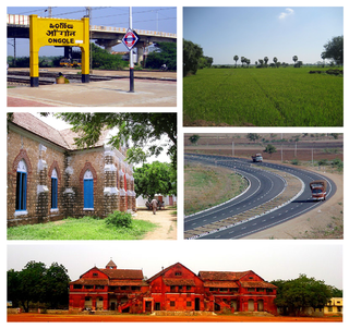
Ongole is a city in Prakasam district of the Indian state of Andhra Pradesh. It is the headquarters of Prakasam district and also the mandal headquarters of Ongole mandal in Ongole revenue division. Ongole cattle, an indigenous breed of oxen, derived its name from Ongole.

Srikakulam is a city and the headquarters of Srikakulam district in the Indian state of Andhra Pradesh. As of 2011 census, it is one of the most populous city of Andhra Pradesh with a population of 146,988. There are many other places of Buddhist Tourism such as Salihundam, Kalinga Patnam, Dabbaka Vaani Peta, Nagari Peta, Jagati Metta etc. in Srikakulam District. The Buddhist heritage site of Salihundam has some unique features. It has a beautiful star atop a stupa, rock cut massive stupaas inside chaitya grihas, brick stupas with wheel pattern plan, votive stupas, inscriptions on the steps leading to the stupas and museum housing over two dozen sculpted statue and figurines of Buddha, Jain Teerthankars and other deities

West Godavari district or Paschima Godavari Jilla is one of the nine districts in the Coastal Andhra region of the Indian state of Andhra Pradesh. The administrative headquarters of the district is situated at Eluru. As of 2011 census of India, the district has an area of 7,742 km2 (2,989 sq mi) and a population of 3,936,966. It is bounded by Krishna district on the west, East Godavari district on the east, Bay of Bengal on the south and the state of Telangana on the north.

Machilipatnam, also known as Masulipatnam, Masulipatam, Masula, and Bandar, is a city in Krishna district of the Indian state of Andhra Pradesh. It is a municipal corporation and the administrative headquarters of Krishna district. It is also the mandal headquarters of Machilipatnam mandal in Machilipatnam revenue division of the district. The ancient port town served as the settlement of European traders from the 16th century, and it was a major trading port for the Portuguese, British, Dutch and French in the 17th century.

Gudivada' is a town in Krishna district of the Indian state of Andhra Pradesh. It is a municipality and the headquarters of Gudivada mandal in Gudivada revenue division. It is one of the cities in the state to be a part of Andhra Pradesh Capital Region. It is Twenty sixth most populous city in the state with a population of 1,18,167.
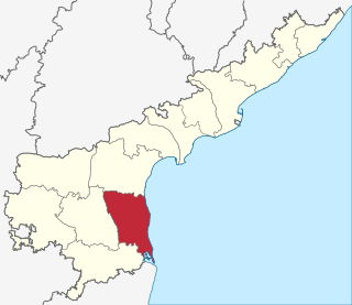
Nellore district, is one of nine districts in the Coastal Andhra region of the Indian state of Andhra Pradesh. According to the 2011 Census, the district's population was 2,966,082, of which 29.07% was urban. Its administrative headquarters are located in Nellore city. The district is bordered by the Bay of Bengal to the east, Kadapa district to the west, Prakasam District to the north, and Chittoor district and Thiruvallur district of Tamil Nadu to the south.
Prakasam district is one of the nine districts in the Coastal Andhra region of the Indian state of Andhra Pradesh. It was formed in 1970. The headquarters of the district is Ongole. It is located on the western shore of Bay of Bengal and is bounded by Guntur district on the north, Kurnool district on the west, Kadapa and Nellore districts on the south. A part of north west region also borders the Mahabubnagar district of Telangana. It is the 3rd largest district in the state and 10th largest in the country with an area of 17,626 km2 (6,805 sq mi) and had a population of 3,392,764 as per 2011 census of India.

Nuzvid is a city in Krishna district of the Indian state of Andhra Pradesh. It serves as the administrative headquarters for Nuzvid mandal and Nuzvid revenue division.

Tadepalligudem (TPG) is a city in West Godavari district of the Indian state of Andhra Pradesh. It is a municipality and the mandal headquarters of Tadepalligudem mandal in Eluru revenue division.
Atmakur is a small town in Nellore district of the Indian state of Andhra Pradesh. It is a municipality located in Atmakur mandal. The town is the headquarters of Atmakur mandal and Assembly Constituency.

Kovur is a town in Nellore district of the Indian state of Andhra Pradesh. The town is the headquarters of the Kovur Mandal and Assembly Constituency. It is located in Kovur mandal of Nellore revenue division. It forms a part of Nellore Urban Development Authority. The poet "Thikkanna" was born in this place.

Nidadavolu is a town in West Godavari district of the Indian state of Andhra Pradesh. It is a municipality and the mandal headquarters of Nidadavolu mandal in Kovvur revenue division.
Rayachoty or "Rachaveedu" or "Rayachoti" or "Rajaveedu" is a town in Kadapa district of the Indian state of Andhra Pradesh. It is a municipality in Rayachoty mandal of Kadapa revenue division. It is one of the oldest town in Andhra Pradesh. Rayachoty is famous for thousand years old The Lord Sri Veerabhadra Swamy temple. It is also called Dakshina Kaasi, build on bank of Mandavya river. Uniqueness of this temple is that Daksha Prajapati appears in worshiping form of the Lord Veerabhadra Swamy.Rayachoty is the 3rd biggest town after Kadapa and Proddatur towns in Kadapa district. It is one of major Educational hubs in the district. It has a Teacher Training Institute[DIET] from Britisher's time. This is one of the oldest DIET in this region. In Rayachoty town one Engineering college and one Government Polytechnic college existed for technical education. It requires more technical institutes and one Medical College for its development. Recently state government announced that Rayachoti is the part of Annamayya Urban Development Agency, it is the good sign for growth of this region.

Renigunta is a census town in Chittoor District of the Indian state of Andhra Pradesh. It is a suburb of Tirupati and the mandal headquarters of Renigunta mandal.

Srikalahasti is a holy town in Chittoor district of the Indian state of Andhra Pradesh. It is a municipality and the mandal headquarters of Srikalahasti mandal in Tirupati revenue division. The town is a part of Tirupati Urban Development Authority, which is located on the banks of the River Swarnamukhi.
Venkatagiri is a town in Nellore district of the Indian state of Andhra Pradesh. It is a municipality and mandals headquarters of Venkatagiri mandal. Venkatagiri's old name is "Kali Mili". It is famous for its Handloom Cotton Sarees. Venkatagiri is a place for history and handlooms. It was part of a small kingdom that was integrated into the Indian Republic.

Chirala, is a City in Prakasam district of the Indian state of Andhra Pradesh. It is a municipality and the headquarters of Chirala mandal in Ongole revenue division. As of 2011, it had a population of above 250,000.

