
The Tamar is a river in south west England, that forms most of the border between Devon and Cornwall. The area is a World Heritage Site due to its historic mining activities.
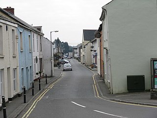
St Blazey is a small town in Cornwall, England, United Kingdom.

Creegbrawse is a hamlet in west Cornwall, England, United Kingdom. It is situated between the villages of Chacewater and Todpool approximately three miles (5 km) east of Redruth.

The River Hayle is a small river in West Cornwall, England, United Kingdom which issues into St Ives Bay at Hayle on Cornwall's Atlantic coast.

Goon Gumpas is a hill and a small settlement in west Cornwall, England, UK. It is two miles (3 km) east of Redruth in a former mining area at grid reference SW 747 427. Just to the south is the mining sett of the former Wheal Maid. It is in the civil parish of Gwennap

Baldhu is a village and parish in Cornwall, England, United Kingdom. It is in the civil parish of Kea.
Bissoe is a hamlet in west Cornwall, England, United Kingdom. It is situated five miles (8 km) east of Redruth in a former tin mining area. It is in the civil parish of Kea
The River Cober is a short river in west Cornwall, England, United Kingdom. It rises in Nine Maidens Downs, directly between Hangman's Barrow to the west and the Nine Maidens stone circle to the east, in the former Kerrier District and runs to the west of the town of Helston before entering the largest natural lake in Cornwall – Loe Pool. The water is impounded by the natural barrier, Loe Bar, and the river system can be traced several kilometres out into Mount's Bay. Mining activity of over one hundred years in the river catchment, ceased in 1938, in the Wendron and Porkellis mining districts; and the engine house of Castle Wary, near Nansloe can still be seen on the east side of the river below Helston. The lower reaches of river was canalised in 1946 and a causeway built over Loe Marsh in 1987. The meaning of the name is uncertain, but two of the earliest records are: "in 1260 we find, 'Chohor' and a few years later, 'Coffar'". The present name 'Cober' is unlikely to be derived from 'Coffar', since it was known as the 'River Loe or River Looe' around four hundred years ago, in Carew's time, according to the map of Powder Hundred.

Scorrier is a village in Cornwall, England, United Kingdom. It is in the civil parish of St Day, about 2 miles (3 km) northeast of the centre of Redruth and 3 miles (5 km) southeast of the coast at Porthtowan, on the A30 road at the junction of the A3047 road that leads west to Camborne and the B3298 road south to Carharrack. The Plymouth to Penzance railway line passes through the village and between 1852 and 1964 it had its own station. A. E. Rodda & Son, the principal maker of clotted cream is based here.
Castle Gate is a hamlet in west Cornwall, England, United Kingdom. It is situated approximately three miles (4.5 km) north-northeast of Penzance at OS grid ref SW491342 in a former mining area.

Luckett is a hamlet in east Cornwall, England. It is situated in a former mining area beside the River Tamar approximately three miles (5 km) north of Callington. According to the Post Office the population at the 2011 census was included in the civil parish of Stokeclimsland

Restronguet Creek is a tidal ria in south Cornwall, United Kingdom. It is a tributary of Carrick Roads, the estuary of the River Fal, and is situated approximately four miles (6.5 km) south of Truro and three miles (5 km) north of Falmouth.

Carnebone is a small hamlet and farm in the parish of Wendron in Cornwall, England. It lies to the east of Wendron, to the northeast of Trevenen, just to the west of Seworgan, along the A394 road, 3.8 miles (6.1 km) northeast of Helston.

Carnhot is a hamlet in the civil parish of Chacewater in Cornwall, England. Carnot lies 2 miles (3.2 km) north-west of Chacewater on the road to Blackwater, Cornwall. Carnot is just to the south of the A30 road.
Carzise is a hamlet in west Cornwall, England. It is 0.5 miles (0.80 km) west of Leedstown and 0.5 miles (0.80 km) south-east of Fraddam. Carzise is situated in the Cornwall and West Devon Mining Landscape which was designated as a World Heritage Site in 2006. It is in the civil parish of Crowan.

Clowance Wood is a hamlet in the civil parish of Crowan in west Cornwall, England. Clowance Wood is situated 1 mile (1.6 km) east of Leedstown and 4.7 miles (7.6 km) north-west of Helston.
Fernsplatt is a hamlet situated 4 miles (6.4 km) east of Redruth in Cornwall, England. Fernsplatt lies at around 70 metres (230 ft) above sea level in the civil parish of Gwennap and is located in the Cornwall and West Devon Mining Landscape which was designated as a World Heritage Site in 2006. It is in the civil parish of Kenwyn.
Halabezack is a hamlet that lies 5 miles (8.0 km) west of Penryn in Cornwall, England.
Mulberry Downs Quarry is a disused opencast quarry, mining tin, in Cornwall, England, UK. The site is a Site of Special Scientific Interest (SSSI), noted for its geological characteristics.

The River Seaton is a river in east Cornwall, England, UK which flows southwards for 11 miles (17 km) into the English Channel.

