| Hamrin Mountains | |
|---|---|
| جبل حمرين (Jabāl Hamrīn), چیای حەمرین (Çiyayê Hemrîn) | |
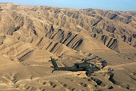 View over Hamrin Mountains | |
| Highest point | |
| Elevation | 250–1,000 m (820–3,280 ft) |
| Coordinates | 35°01′57″N43°38′47″E / 35.0325°N 43.6463889°E |
| Geography | |
 Hamrin Mountains | |
 | |
| Country | |
| Governorates | |
| Parent range | Zagros Mountains |
| Geology | |
| Mountain type | Anticlinal fold |
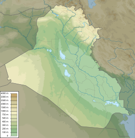
The Hamrin Mountains (Arabic : جبل حمرين, romanized: Jabāl Hamrīn, Kurdish : چیای حەمرین, romanized: Çiyayê Hemrîn or Çiyayên Hemrîn) are a small mountain ridge in northeast Iraq. The westernmost ripple of the Zagros Mountains, [1] the Hamrin mountains extend from the Diyala Governorate bordering Iran, northwest to the Tigris river, crossing northern Saladin Governorate and southern Kirkuk Governorate.
Historically the Hamrin mountains were called Barima, Bārimā and Birimma (Arabic : جبل بارِمّا, romanized: Jabāl Bārimā). [2] Ibn Khaldun, a 14th century historian called the Hamrin mountains range, the "Kurdish mountains". That is because these mountains are situated in the south of Kirkuk and Kurds lived there, so, Ibn Khaldun said, "the range Hamrin mountains is a place whose people are Kurdish." [3] [4]