
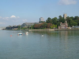
The River Stour is a river in Kent, England that flows into the North Sea at Pegwell Bay. Above Plucks Gutter, where the Little Stour joins it, the river is normally known as the Great Stour. The upper section of the river, above its confluence with the East Stour at Ashford is sometimes known as the Upper Great Stour or West Stour. In the tidal lower reaches, the artificial Stonar Cut short cuts a large loop in the natural river.
The River Medway is a river in South East England. It rises in the High Weald, Sussex and flows through Tonbridge, Maidstone and the Medway conurbation in Kent, before emptying into the Thames Estuary near Sheerness, a total distance of 70 miles (113 km). About 13 miles (21 km) of the river lies in Sussex, with the remainder being in Kent.

The River Dart is a river in Devon, England, that rises high on Dartmoor and flows for 75 kilometres (47 mi) to the sea at Dartmouth.

The River Dearne South Yorkshire, England flows roughly east for more than 30 kilometres (19 mi), from its source just inside West Yorkshire. It flows through Denby Dale, Clayton West, Darton, Barnsley, Darfield, Wath upon Dearne, Bolton on Dearne, Adwick upon Dearne and Mexborough to its confluence with the River Don at Denaby Main. Its main tributary is the River Dove, which joins it at Darfield. The river was one of those affected by the 2007 United Kingdom floods.

The Humber River is a river in Southern Ontario, Canada. It is in the Great Lakes Basin, is a tributary of Lake Ontario and is one of two major rivers on either side of the city of Toronto, the other being the Don River to the east. It was designated a Canadian Heritage River on September 24, 1999.

South Hams is a local government district on the south coast of Devon, England. Services divide between those provided by its own Council headquartered in Totnes, and those provided by Devon County Council headquartered in the city of Exeter.
The River Exe in England rises at Exe Head, near the village of Simonsbath, on Exmoor in Somerset, 8.4 kilometres (5 mi) from the Bristol Channel coast, but flows more or less directly due south, so that most of its length lies in Devon. It flows for 60 miles (96 km) and reaches the sea at a substantial ria, the Exe Estuary, on the south coast of Devon. Historically, its lowest bridging point was at Exeter, which is the largest settlement on the river, but there is now a viaduct for the M5 motorway about 3 kilometres (2 mi) south of the city centre.
The River Lea is in South East England. It originates in Bedfordshire, in the Chiltern Hills, and flows southeast through Hertfordshire, along the Essex border and into Greater London, to meet the River Thames at Bow Creek. It is one of the largest rivers in London and the easternmost major tributary of the Thames.

The River Coquet runs through the county of Northumberland, England, discharging into the North Sea on the east coast at Amble. It rises in the Cheviot Hills on the border between England and Scotland, and follows a winding course across the landscape. The upper reaches are bordered by the Otterburn Ranges military training ground, and are crossed by a number of bridges built in the 20th century. It passes a number of small villages and hamlets, and feeds one of the lakes created by extraction of gravel that form the Caistron Nature Reserve, before reaching the town of Rothbury, where it is crossed by a grade II listed bridge. Below the town is Thrum Mill, the restoration of which was featured on Channel 4 television.
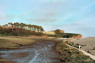
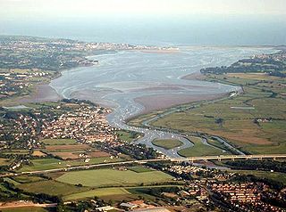
The River Otter rises in the Blackdown Hills just inside the county of Somerset, England near Otterford, then flows south through East Devon. It enters the English Channel at the western end of Lyme Bay, part of the Jurassic Coast, a UNESCO World Heritage Site. The Permian and Triassic sandstone aquifer in the Otter Valley is one of Devon's largest groundwater sources, supplying drinking water to 200,000 people.
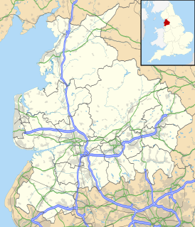
The River Wyre is a river in Lancashire, England, United Kingdom, which flows into the Irish Sea at Fleetwood. It is approximately 28 miles (45 km) in length. The river is a County Biological Heritage Site and has a sheltered estuary which, from its northwest corner, penetrates deep into the almost square peninsula of the Fylde.

The River Blackwater is a river in Essex, England. It rises as the River Pant in the northwest of the county, just east of Saffron Walden, and flows in a generally southeast direction to Bocking, near Braintree, via Great Sampford and Great Bardfield. At Bocking, it becomes the River Blackwater, and veers east to flow past Bradwell Juxta Coggeshall and Coggeshall. It then veers south, flowing past Kelvedon and Witham, before reaching Maldon. There, it veers east again and empties into the Blackwater Estuary, which in turn meets the North Sea at Mersea Island.

The River Kent is a short river in the county of Cumbria in England. It originates in hills surrounding Kentmere, and flows for around 20 miles (32 km) into the north of Morecambe Bay. The upper reaches and the western bank of the estuary are located within the boundaries of the Lake District National Park. The river flows in a generally north to south direction, passing through Kentmere, Staveley, Burneside, Kendal and Sedgwick. Near Sedgwick, the river passes through a rock gorge which produces a number of low waterfalls. This section is popular with kayakers as it offers high quality whitewater for several days after rain. The village of Arnside is situated on the east bank of the Kent estuary, just above Morecambe Bay, and a tidal bore known as the Arnside Bore forms in the estuary at this point on high spring tides.

The name Rea Brook can refer to either of two brooks in Shropshire, England.

The Truro River is a river in the city of Truro in Cornwall, England, UK. It is the product of the convergence of the two rivers named Kenwyn and Allen which run under the city: the Truro River flows into the River Fal, estuarial waters where wildlife is abundant, and then out into the Carrick Roads. The river is navigable up to Truro.

Ashprington is a village and civil parish in the South Hams district of Devon, England. The village is not far from the River Dart, but high above it, and is about three miles south of Totnes. There is a local pub, hotel and phonebox. The civil parish includes the hamlets of Bow, Painsford and Tuckenhay. Sharpham House is also within the parish and includes Sharpham Vineyard which produces good quality wines. According to the 2001 census the parish had a population of 428.
Harberton is a village, civil parish and former manor 3 miles south west of Totnes, in the South Hams District of Devon, England. The parish includes the village of Harbertonford situated on the main A381 road. In the 2001 census the parish had a population of 1,285. The village is a major part of the electoral ward of Avon and Harbourne. At the 2011 census the ward population was 2,217.
The Steinlach is a river with a length of 26 km (16 mi) in Baden-Württemberg, Germany. It is a tributary to the Neckar.
Holne Ridge, on Dartmoor, includes some of southern Dartmoor's highest land. The ridge to the south west overlooks mires and bogs like Aune Head Mires. To the north east it overlooks the Dart Gorge with its many tors; Sharp Tor, for example. It also includes many notable features including:
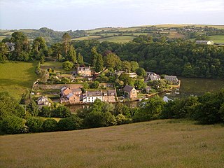
Tuckenhay is a hamlet in the South Hams in Devon, England, 2.5 miles (4.0 km) south of Totnes. It lies on the south bank of Bow Creek, the estuary of the Harbourne River, which flows into the River Dart.

