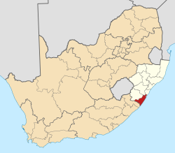
Harding, South Africa

Last updated
Harding
South Africa KwaZulu-Natal location map.svg
Red pog.svg
Harding
South Africa adm location map.svg
Red pog.svg
Harding
Coordinates: 30°35′S29°53′E / 30.583°S 29.883°E / -30.583; 29.883
Country South Africa
Province KwaZulu-Natal
District Ugu
Municipality UMuziwabantu
Area
[1]
  Total25.18 km2 (9.72 sq mi)
Population
 (2011) [1]
  Total9,544
  Density380/km2 (980/sq mi)
Racial makeup (2023)
[1]
   Black African 77.3%
   Coloured 19.5%
   Indian/Asian 11.3%
   White 3.1%
  Other2.8%
First languages (2023)
[1]
   Zulu 57.4%
   Xhosa 36.6%
   English 12.6%
   Afrikaans 3.8%
  Other4.7%
Time zone UTC+2 (SAST)
Postal code (street)
4680
PO box
4680
Area code 039

Harding is a town situated in the Mzimkulwana River valley, Ugu District Municipality of KwaZulu-Natal, South Africa

Contents

Background

Harding was established as a military outpost following the British annexation of East Griqualand in 1874. Named after Sir Walter Harding (c 1812-1874) who in 1858 became the first Chief Justice in Natal. [2] It was declared as a township in 1911. [3]

Timber and dairy farming are the main economic activities. The abandoned 122 kilometres (76 mi) narrow gauge Alfred County Railway used to serve the farming areas, linking Harding with Port Shepstone. Harding lies at the foot of the Ingeli Range, 34 km north-west of Izingolweni and 84 km north-west of Port Shepstone. [3] :256

Administration

Harding is located in the uMuziwabantu Local Municipality which is located in the larger Ugu District Municipality which governs the KwaZulu-Natal South Coast. It is the municipal seat of the uMuziwabantu Local Municipality which governs Harding, Weza and its surroundings.

Related Research Articles

<span class="mw-page-title-main">KwaZulu-Natal</span> Province in South Africa

KwaZulu-Natal is a province of South Africa that was created in 1994 when the government merged the Zulu bantustan of KwaZulu and Natal Province.

<span class="mw-page-title-main">Margate, South Africa</span> Resort town in KwaZulu-Natal, South Africa

Margate is a coastal resort town in the KwaZulu-Natal province, about 20 kilometres south-west of Port Shepstone and 127 kilometres south-west of Durban. The river which flows into the sea at Margate is called "Nkhongweni" (place of entreaty) as the original inhabitants of the area were reputed to be so mean resulting in travellers begging for hospitality.

<span class="mw-page-title-main">Port Shepstone</span> Coastal town in KwaZulu-Natal, South Africa

Port Shepstone is a large town situated on the mouth of the Mzimkhulu River, the largest river on the KwaZulu-Natal South Coast of South Africa. It is located halfway between Hibberdene and Margate and is positioned 120 km south of Durban. It serves as the administrative, educational, industrial and commercial centre for southern Natal.

<span class="mw-page-title-main">Scottburgh</span> Place in KwaZulu-Natal, South Africa

Scottburgh is a coastal resort town located along the south coast of KwaZulu-Natal, South Africa. It situated south of the mouth of the Mpambanyoni River (confuser of birds).

<span class="mw-page-title-main">Port Edward, South Africa</span> Seaside town in KwaZulu-Natal, South Africa

Port Edward is a small resort town situated on the south coast of KwaZulu-Natal in South Africa and lies on the border between KwaZulu-Natal and the Eastern Cape. It is situated on the R61 road between Port Shepstone and Lusikisiki.

Hibberdene is a small coastal town on the KwaZulu-Natal South Coast in South Africa, approximately 23 km north-east of Port Shepstone and 90 km south-west of Durban and halfway between coastal towns of Scottburgh and Margate.

Umtentweni, also officially known as eMthenteni, is a small coastal resort on the South Coast of KwaZulu-Natal, South Africa, between the Mzimkulu River (the great home of all rivers) and the Mtentweni River. It forms part of the coastal town of Port Shepstone in the Ray Nkonyeni Local Municipality, KwaZulu-Natal, South Africa. It is a relatively clean and quiet residential resort; it has become an attractive destination for people aiming to get away from city life. Most of the village is filled with complexes, flats, bed and breakfasts and suburban-style houses. Twenty years ago the whole of Umtentweni consisted of a lot of greenery and wildlife. All this has changed due to the growing popularity of this small resort and the constant clearing for new housing.

<span class="mw-page-title-main">Umzumbe</span> Seaside town in KwaZulu-Natal, South Africa

Umzumbe is a seaside resort situated at the mouth of the Mzumbe River (bad kraal) in KwaZulu-Natal, South Africa. The name of the river is derived from a band of Hlongwa cannibals who occupied the valley. The Hlongwa was almost wiped out by the Zulu king Shaka in 1828.

<span class="mw-page-title-main">Ugu District Municipality</span> District municipality in KwaZulu-Natal, South Africa

The Ugu District Municipality is one of the 11 districts of the KwaZulu-Natal province of South Africa. Ugu is isiZulu for "coast". It governs the KZN South Coast and its seat is Port Shepstone. The majority of its 722,484 inhabitants spoke isiZulu as of 2011. The district code is DC21.

<span class="mw-page-title-main">Vulamehlo Local Municipality</span> Local municipality in KwaZulu-Natal, South Africa

Vulamehlo Local Municipality was a local municipality in Ugu District Municipality, KwaZulu-Natal. It was located south of the eThekwini municipality and bordered by uMdoni to the east, Mkhambathini and Richmond to the north and Ubuhlebezwe to the west. There is an almost equal split of land between commercial agriculture and traditional settlement areas. 48% of the area is held under communal ownership through traditional authorities; the balance of the area is privately owned, except for Vernon Crookes Nature Reserve, which is managed by Ezemvelo KZN Wildlife. In 2016 the municipality was divided between eThekwini and uMdoni.

uMuziwabantu Local Municipality Local municipality in KwaZulu-Natal, South Africa

uMuziwabantu Municipality is a local municipality within the Ugu District Municipality, in the KwaZulu-Natal province of South Africa. uMuziwabantu is an isiZulu word meaning "the people's home", or "a home with wide open doors where everyone is welcome". The main source of income for the area is derived from the municipality's extensive wattle, gum, pine and poplar plantations, and associated industries, including saw mills and furniture-making factories.

Marburg is a settlement in the Ugu District Municipality in the KwaZulu-Natal province of South Africa, situated approximately 112 kilometres south-west of the city of Durban. Marburg was a Norwegian settlement given the name Marburg for a nearby German mission. The Norwegian founders played a significant role in the development of Marburg and Port Shepstone, which it forms part of today. The British colonial government gave the settlers a free voyage to South Africa and also houses and 100 acres of land. Marburg was the only successful Scandinavian settlement in South Africa.

<span class="mw-page-title-main">Mthwalume</span> Place in KwaZulu-Natal, South Africa

Mtwalume, also known as Umtalumi, is a settlement in Ugu District Municipality in the KwaZulu-Natal province of South Africa.

Izingolweni or eZinqoleni is a town in Ugu District Municipality in the KwaZulu-Natal province of South Africa. It was founded in the 1870s as a police and administration post. The name comes from the Zulu language word for "place with very shallow holes." Izingolweni also consists of a school called Izingolweni Primary which is rumored that it was built by the community. This very school is the center of excellence in the place. It is very exceptional and produces very fine learners each year.

<span class="mw-page-title-main">Shelly Beach, South Africa</span> Place in KwaZulu-Natal, South Africa

Shelly Beach is a coastal resort town on the South Coast of the KwaZulu-Natal province of South Africa, located more or less halfway between Margate and Port Shepstone.

St Faith’s is a village in the Umzumbe Local Municipality in the KwaZulu-Natal province of South Africa.

<span class="mw-page-title-main">South Coast (KwaZulu-Natal)</span> Coastal region in KwaZulu-Natal, South Africa

KwaZulu-Natal South Coast is a region along the southern stretch of coastline of KwaZulu-Natal, South Africa, south of the coastal city of Durban.

Boboyi, or Bhobhoyi, is a rural settlement in KwaZulu-Natal, South Africa. It is located 8 km west of Port Shepstone and is named after the Boboyi River which runs through the area.

Murchison is a settlement in the Ugu District Municipality in KwaZulu-Natal, South Africa.

<span class="mw-page-title-main">Amandawe</span> Township in KwaZulu-Natal Province, South Africa

Amandawe also known as Amandawe Mission, or often informally abbreviated as A.M.A or A.M is a small township in the KwaZulu-Natal South Coast region of South Africa. The area is mostly populated with Black Africans.

References

  1. 1 2 3 4 "Main Place Harding". Census 2011.
  2. "Dictionary of Southern African Place Names (Public Domain)". Human Science Research Council. p. 198.
  3. 1 2 Conolly, Denis (1975). The Tourist in South Africa. Travel-Guide (PTY) LTD. ASIN   B0000E7XZN.