Hartsville, Pennsylvania

Last updated
Hartsville, Pennsylvania
Populated place
Hartsville Fire Company 9-11 Memorial.jpeg
Hartsville Fire Company 9/11 Memorial
USA Pennsylvania location map.svg
Red pog.svg
Hartsville
Location of Hartsville in Pennsylvania
Usa edcp location map.svg
Red pog.svg
Hartsville
Hartsville (the United States)
Coordinates: 40°13′42″N75°05′42″W / 40.22833°N 75.09500°W / 40.22833; -75.09500
Country United States
State Pennsylvania
County Bucks
Elevation
[1]
249 ft (76 m)
Time zone UTC-5 (Eastern (EST))
  Summer (DST) UTC-4 (EDT)
ZIP code
18974
Area code(s) 215, 267, and 445
FIPS code 42-32984
GNIS feature ID 1192587

Hartsville is a populated place that is situated at the crossroads of Bristol Road and the Old York Road, and straddles Warminster and Warwick Township in Bucks County, Pennsylvania, United States. [2]

Contents

It has an estimated elevation of 427 feet (130 m) above sea level, and is served by the Warminster Post Office ZIP code of 18974.

History

Hartsville was named for Colonel William Hart, who served during the Revolutionary War. After relocating to the village during the late 1700s, he opened a new inn which he called "The Sign of the Hart." [3] [4]

Initially a station stop on the Pennsylvania Northeastern Railroad that was named Hartville, that railroad depot was later renamed Ivyland. [5]

As a town gradually formed around the stop and inn, the town was renamed as Hartsville and more services were added to meet the needs of the growing population. A Presbyterian church opened its doors in Hartsville in 1839, and continued to serve its congregation until 1939, when it merged with another church; its Hartsville building was then torn down. [6] [7] The church's cemetery is perpetually maintained. [8]

A collection in the Metropolitan Museum of Art includes an 1843 cut-paper silhouette portrait of a Hartsville resident identified as Mrs. James P. Wilson. [9]

Recent history

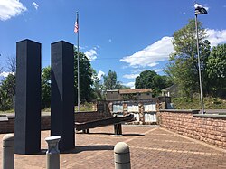
The Hartsville Fire Company is the site of a 9/11 memorial. [10] [11]

In 2019, water from private wells in the community was reportedly unsafe to drink because of contamination by per- and polyfluoroalkyl substances (PFAS) chemicals, possibly from toxic waste from closed military facilities nearby. [12]

Related Research Articles

<span class="mw-page-title-main">Bucks County, Pennsylvania</span> County in Pennsylvania, United States

Bucks County is a county in the Commonwealth of Pennsylvania. As of the 2020 census, the population was 646,538, making it the fourth-most populous county in Pennsylvania. Its county seat is Doylestown. The county is named after the English county of Buckinghamshire.

<span class="mw-page-title-main">Langhorne, Pennsylvania</span> Borough in Pennsylvania, United States

Langhorne Borough is a borough in Bucks County, Pennsylvania, United States. The population was 1,622 at the time of the 2010 census.

<span class="mw-page-title-main">Northampton Township, Bucks County, Pennsylvania</span> Township in Pennsylvania, United States

Northampton Township is a township in Bucks County, Pennsylvania, United States. The township is located approximately 12 miles northeast of Philadelphia. The population was 39,915 at the 2020 census.

<span class="mw-page-title-main">Warminster Township, Pennsylvania</span> Township in Pennsylvania, United States

Warminster Township, also referred to as Warminster, is located in Bucks County, Pennsylvania, United States. It was formally established in 1711. The township is 13.7 miles north of Philadelphia and had a population of 33,603 according to the 2020 U.S. census.

<span class="mw-page-title-main">Warrington Township, Bucks County, Pennsylvania</span> Township in Pennsylvania, United States

Warrington Township is a township in Bucks County, Pennsylvania, United States. Warrington Township is a northern suburb of Philadelphia. The population was 25,639 at the 2020 census.

<span class="mw-page-title-main">Warwick Township, Bucks County, Pennsylvania</span> Township in Pennsylvania, United States

Warwick Township is a township in Bucks County, Pennsylvania, United States. The population was 14,437 at the 2010 census.

<span class="mw-page-title-main">Hatboro, Pennsylvania</span> Borough in Pennsylvania, United States

Hatboro is a borough in Montgomery County, Pennsylvania, United States. The population was 8,238 at the 2020 census.

<span class="mw-page-title-main">Southampton, Pennsylvania</span> Unincorporated community in Pennsylvania, United States

Southampton is an unincorporated community located in Upper Southampton Township, Bucks County, Pennsylvania.

<span class="mw-page-title-main">Pennsylvania Route 132</span> State highway in Bucks County, Pennsylvania, US

Pennsylvania Route 132 (PA 132) is a state highway in southeast Pennsylvania. The route, which is signed east–west, runs northwest to southeast through Bucks County in suburban Philadelphia from PA 611 in Warrington southeast to Interstate 95 (I-95) in Bensalem. PA 132 is a commercial route lined with shopping centers throughout much of its 15-mile (24 km) length. It is named Street Road and is five lanes wide for much of its length. The route was also designated as the Armed Forces and Veterans Memorial Highway in 2005. From west to east, PA 132 intersects PA 263 and PA 332 in Warminster; PA 232 in Southampton; PA 532 in Feasterville; and U.S. Route 1 (US 1), the Pennsylvania Turnpike (I-276), PA 513, and US 13 in Bensalem. Street Road was included in William Penn's survey plans and completed by 1737. The road was paved by 1911 and received the PA 132 designation between US 611 and US 13 by 1927. The route was widened into a multilane highway and extended east from US 13 to I-95 by 1970. An interchange with the eastbound direction of the Pennsylvania Turnpike opened in 2010.

<span class="mw-page-title-main">Neshaminy Creek</span> River in Pennsylvania, United States

Neshaminy Creek is a 40.7-mile-long (65.5 km) stream that runs entirely through Bucks County, Pennsylvania, rising south of the borough of Chalfont, where its north and west branches join. Neshaminy Creek flows southeast toward Bristol Township and Bensalem Township to its confluence with the Delaware River.

<span class="mw-page-title-main">Pennsylvania Route 263</span> North–south state highway located in southeast Pennsylvania

Pennsylvania Route 263 (PA 263) is a north–south state highway located in southeast Pennsylvania. The southern terminus of the route is at PA 611 in Willow Grove, Montgomery County. The northern terminus is at the Centre Bridge–Stockton Bridge over the Delaware River in Centre Bridge, Bucks County, where the road continues into Stockton, New Jersey, as Bridge Street to an intersection with Route 29. PA 263 follows the routing of Old York Road, a historic road that connected Philadelphia to New York City, and carries the name York Road from the southern terminus to Lahaska and Upper York Road north of there. From Willow Grove to Buckingham, PA 263 runs mostly through suburban areas as a four-lane road, passing through Hatboro, Warminster, and Jamison. The route forms a concurrency with U.S. Route 202 (US 202) in Buckingham and narrows to a two-lane road, splitting with that route in Lahaska. From here, the route continues through rural areas to Centre Bridge.

<span class="mw-page-title-main">William Tennent</span> Religious leader and educator in early America

William Tennent was an early Scottish American Presbyterian minister and educator in British North America.

<span class="mw-page-title-main">Log College</span> First seminary serving Presbyterians in North America

The Log College, founded in 1727, was the first theological seminary serving Presbyterians in North America, and was located in what is now Warminster, Pennsylvania. It was founded by William Tennent and operated from 1727 until Tennent's death in 1746, and it graduated proponents on the New Side of the significant Old Side–New Side Controversy that divided presbyterianism in colonial America at the time. The Log College was, as a physical structure, very plain, according to George Whitefield's journal; it was a private institution that had no charter. At that time, ministers could not get ordained unless they had graduated from Harvard, Yale, or a college in England. Thus, an important purpose in its founding was to support the spread of New Light Christianity by enabling proponents to become ordained. In sources dated through the early 20th century, it was referred to as a remarkable institution, with graduates including Samuel Finley, John Redman, and John Rowland. Though the number of eventual graduates is unknown, many would play important roles in the Old Side–New Side Controversy, and Log College alumni Samuel Blair, Samuel Finley, and William Tennent, Jr. would become trustees of a newly formed College of New Jersey, which would be renamed Princeton University in 1896.

<span class="mw-page-title-main">Pennsylvania Route 332</span> State highway in Pennsylvania, US

Pennsylvania Route 332 (PA 332) is a state highway in the U.S. state of Pennsylvania. The route runs 17.5 miles (28.2 km) from PA 263 in Hatboro, Montgomery County, east to PA 32 in Yardley, Bucks County. PA 332 runs through suburban areas to the north of Philadelphia, serving Warminster, Ivyland, Richboro, and Newtown. The route is two lanes wide most of its length, with the bypass around Newtown a four-lane divided highway. PA 332 intersects PA 132 in Warminster, PA 232 in Richboro, PA 413 and PA 532 in Newtown, and Interstate 295 (I-295) in Lower Makefield Township.

Old York Road, originally York Road, with reference to New York, is a roadway that was built during the 18th century to connect Philadelphia with New York City.

<span class="mw-page-title-main">Moland House</span> Historic house in Pennsylvania, United States

Moland House is an old stone farmhouse built around 1750, by John Moland, a Philadelphia and Bucks County lawyer. Although physically located in Hartsville, Warwick Township, Bucks County, Pennsylvania, its mailing address is in Warminster Township, Pennsylvania.

<span class="mw-page-title-main">Pennsylvania Northeastern Railroad</span> Shortline railroad in southeastern Pennsylvania

The Pennsylvania Northeastern Railroad is a short-line railroad operating on trackage mostly in Bucks and Montgomery counties to the north of Philadelphia, Pennsylvania. It was created in 2011, taking over former operations from CSX Transportation. The Pennsylvania Northeastern Railroad interchanges with CSX in Lansdale, the East Penn Railroad in Telford, and the New Hope Railroad in Warminster.

<span class="mw-page-title-main">John Barclay (mayor)</span> American politician

John Barclay was an American soldier, politician, and jurist. He served in the Continental Army during the American Revolution. He served as President Judge of the Courts for Bucks County, Pennsylvania, alderman in Philadelphia, and Mayor of Philadelphia from 1791 to 1793. He worked as president of the Bank of Pennsylvania and was one of the founders of the Insurance Company of North America. He served as a Federalist member of the Pennsylvania State Senate for the 1st district from 1811 to 1813.

<span class="mw-page-title-main">Little Neshaminy Creek</span> River in Pennsylvania, United States

Little Neshaminy Creek is a tributary of the Neshaminy Creek, part of the Delaware River Watershed rising near the intersection of U.S. Route 202 and Pennsylvania Route 309 near Montgomeryville, Pennsylvania and meets its confluence with Neshaminy Creek at the Neshaminy's 24.10 River mile.

<span class="mw-page-title-main">Warminster Branch</span>

The Warminster Branch is a railway line in the state of Pennsylvania. It runs 8.3 miles (13.4 km) from a junction with the SEPTA Main Line just north of Glenside to Warminster, where it meets the New Hope Railroad. It was originally built by the North East Pennsylvania Railroad, a subsidiary of the North Pennsylvania Railroad, between 1872 and 1874. It was part of the Reading Company system from 1879 until 1976. Today it is owned by SEPTA and hosts Warminster Line commuter rail service. A later extension of the branch to New Hope, Pennsylvania is now the New Hope Railroad heritage railway.

References

  1. "Feature Detail Report for: Hartsville". Geographic Names Information System . United States Geological Survey, United States Department of the Interior.
  2. "Hartsville (in Bucks County, PA) Populated Place Profile". PA Hometown Locator. Retrieved December 18, 2015.
  3. The Villages of Bucks County: A Guidebook, Bucks County Planning Commission, 1987
  4. Battle, J. H. History of Bucks County, Pennsylvania: Including an Account of Its Original Exploration. Reprint Company. ISBN   9780871524096.
  5. "Bucks County Pennsylvania Railroad Stations". www.west2k.com. Retrieved November 10, 2021.
  6. "Neshaminy-Warwick Presbyterian Church Hartsville, Pennsylvania". Journal of Presbyterian History (1962-1985). 60 (2): 144. 1982. ISSN   0022-3883. JSTOR   23328530.
  7. Gemmill, Helen Hartman (1976). A history of Neshaminy-Warwick Presbyterian Church, 1726-1976: in commemoration of its 250th anniversary. Place of publication not identified: publisher not identified. OCLC   5247623.
  8. "Neshaminy-Warwick Presbyterian Church Cemetery Hartsville, Pennsylvania". Journal of Presbyterian History (1962-1985). 60 (2): 160. 1982. ISSN   0022-3883. JSTOR   23328532.
  9. "Mrs. James P. Wilson of Hartsville, Pennsylvania. 1843. Auguste Edouart French". www.metmuseum.org. Retrieved 2021-11-10.
  10. "Hartsville Fire Company secures World Trade Center beam for 9/11 memorial". thereporteronline. 2011-04-24. Retrieved 2021-11-10.
  11. "Hartsville Fire Company secures World Trade Center beam for 9/11 memorial". 2011-04-24. Retrieved November 10, 2021.
  12. McDaniel, Justine (June 28, 2019). "This Pa. neighborhood with tainted wells has been on bottled water for three years. No end is in sight". www.inquirer.com. Retrieved 2021-11-10.