Haymarket Square (Boston)

Last updated
View of Haymarket Square, an 1863 illustration View of Haymarket Square, 1853.png
View of Haymarket Square, an 1863 illustration

Haymarket Square is the historic name of a former town square in Boston, located between the North End, Government Center, the Bulfinch Triangle, and the West End. The square was a well-known feature of Boston from the mid-19th century to the mid-20th century, when the buildings around it were demolished to make way for the Central Artery [1] and Government Center. The Haymarket produce market continues to operate at a location near the historic site of the square. The Haymarket MBTA station extends under the former site of the square.

Contents

17th and 18th centuries: Mill Cove to Mill Pond

1645 map 1645 Boston byGeorgeLamb.png
1645 map
1743 map 1743 NorthEnd Boston map WilliamPrice.png
1743 map

During the early years of European settlement, the future site of Haymarket Square was in a part of Boston Harbor called Mill Cove. [2] :73 The cove (not labeled) appears to the southwest of Mill Hill (later renamed Copp's Hill) on the 1645 map.

The mouth of Mill Cove was dammed in the 1640s, turning it into Mill Pond. [2] :74 Several mills and rum distilleries, powered by tidal water flows, were built on the shores of the pond. [3]

The future location of Haymarket was just north of the "Water Mill" shown on the 1743 map.

19th century: creation of the square

Plan for the filling of the Bulfinch Triangle, 1807. Haymarket Square is at bottom center, at the southern end of Canal Street. Manuscript plan of the Bulfinch Triangle, Boston, MA (2674588524).jpg
Plan for the filling of the Bulfinch Triangle, 1807. Haymarket Square is at bottom center, at the southern end of Canal Street.
"The Taking Down of Beacon Hill", by John Rubens Smith Old Boston. Beacon Hill from Mt. Vernon St., near the head of Hancock St. - from a drawing made on the spot by J.R. Smith in 1811, 12 ; J.H. Bufford's Lith. 313 Washington St. LCCN2002725395.tif
"The Taking Down of Beacon Hill", by John Rubens Smith

Mill Pond was cut off from most water flows by the mill dam, and was used as a waste dumping site by neighboring homes and businesses. [4] The polluted water was regarded as a source of disease. [5] :120 At the same time, population growth led town officials to look for ways to increase the supply of buildable land. [4] :73

In 1807, the town of Boston gave the Boston Mill Corporation (under the leadership of William Tudor and Harrison Gray Otis, [6] ) permission to begin filling in the pond. [2] :80 [7] A street plan for the filled land was proposed in 1808 by Charles Bulfinch. [2] :81 Filling of the pond to create the area now known as the Bulfinch Triangle was completed in 1828. [2] :92 The fill material was obtained by cutting down a portion of Beacon Hill. [5] [2] :84 The future location of Haymarket Square, where Merrimack, Canal, and Charleston Streets converged at the southern tip of the Bulfinch Triangle, appears on an 1826 map. [8]

Haymarket Square Boston 1835 Panorama.jpg
360 degree view of Haymarket Square painted in about 1895, that "purports to show the area in 1835." [2] :98 It shows Haymarket Square connected to Boston Harbor by Canal Street, along which also ran railroad tracks and the canal for which the street was named.
1844 map with the first use of the name "Haymarket Square" Bulfinch Triangle detail of 1844 Boynton Plan of the City of Boston.JPG
1844 map with the first use of the name "Haymarket Square"
"View of the new land in 1828" View of the new land in 1828, Boston.JPG
"View of the new land in 1828"

Maps from as early as 1814 show a market at the intersection of Merrimack, Canal, and Charlestown Streets. [2] :87 The name "Haymarket Square" appears on an 1844 map. [9] No earlier map on the City of Boston atlas includes the name. [10] A drawing published in 1895 [11] entitled "View of the New Land in 1828" also shows the name "Haymarket Square". The name was applied because the square was "the site of one of several public scales used for weighing and selling hay." [12] Images from the mid-1800s show hay being sold in the square. [13] The Haymarket Pushcart Association, [14] [15] which traces its history to 1820, still operates the Haymarket market a block away. [16]


Boston and Maine depot Boston and Maine Railroad terminal from stereo card.jpg
Boston and Maine depot
1909 view. The kiosk is an entrance to the Haymarket station of the Tremont Street Subway. The Haymarket Relief Station is at rear. Haymarket Square.JPG
1909 view. The kiosk is an entrance to the Haymarket station of the Tremont Street Subway. The Haymarket Relief Station is at rear.

From its opening in 1845 to its demolition in 1897, the most prominent building on the square was the Boston and Maine Railroad depot. [17] According to an 1892 guidebook, "The Boston and Maine Railroad, alone of all lines entering the city on the north side, enjoys the privilege of penetrating within the outer street. Its station is in Haymarket Square, and the open space in front of it gives prominence to the structure." [18] The railroad provided service to Lowell, Portland, and Lake Winnipesaukee. [19] :139

In 1893, the depot was replaced by North Union Station, several blocks to the north on Causeway Street. The depot was demolished to make way for construction of the Haymarket Relief Station [20] (a branch of Boston City Hospital) and the Canal Street incline (the northern end of the Tremont Street subway, the predecessor to the MBTA Green Line). The Haymarket station on the subway line opened in 1898, with an entrance kiosk in the center of Haymarket Square. Workers excavating for the station and incline uncovered a portion of the wall of the Middlesex Canal, which formerly terminated at the square. [19]

20th century: destruction

All the buildings around the square, as well as the square itself, were demolished in the 1950s for the construction of the elevated Central Artery [1] or in the 1960s and 1970s for the construction of Government Center. Architectural critic Robert Campbell wrote in 1992 that the former site of the Relief Station resembled "a shell-torn battlefield." [21] During the construction of the 2,300-space Government Center Garage, the MBTA Haymarket Station was rebuilt. The northeast corner of the garage was located on the former location of Haymarket Square. [22]


21st century: further changes

Bulfinch Crossing under construction in 2022 Bulfinch Crossing P1040060.jpg
Bulfinch Crossing under construction in 2022

Construction began in January 2017 [23] on Bulfinch Crossing, [24] a 2.9 million square foot redevelopment on the site of the Government Center Garage. [25] The northeast corner of the garage is at the location of Haymarket Square.

"Haymarket Square" was the original name of a hotel and market building [26] which began construction in 2018 [27] on Blackstone Street, a block south of the historic location of Haymarket Square. The hotel's name was later changed to the "Canopy by Hilton Boston Downtown". [28] The hotel opened in 2022. [29]

Related Research Articles

<span class="mw-page-title-main">North End, Boston</span> Neighborhood of Boston in Suffolk, Massachusetts, United States

The North End is a neighborhood of Boston, Massachusetts, United States. It has the distinction of being the city's oldest residential community, where Europeans have continuously inhabited since it was colonized in the 1630s. Though small, only 0.36 square miles (0.93 km2), the neighborhood has nearly one hundred establishments and a variety of tourist attractions. It is known for its Italian American population and Italian-themed restaurants. The district is a pending Boston Landmark.

<span class="mw-page-title-main">Government Center, Boston</span> Area in downtown Boston, Massachusetts

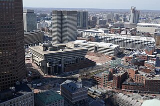
Government Center is an area in downtown Boston, centered on City Hall Plaza. Formerly the site of Scollay Square, it is now the location of Boston City Hall, courthouses, state and federal office buildings, and a major MBTA subway station, also called Government Center. Its development was controversial, as the project displaced thousands of residents and razed several hundred homes and businesses.
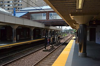
<span class="mw-page-title-main">North Station</span> Train station in Boston, Massachusetts, US

North Station is a commuter rail and intercity rail terminal station in Boston, Massachusetts. It is served by four MBTA Commuter Rail lines – the Fitchburg Line, Haverhill Line, Lowell Line, and Newburyport/Rockport Line – and the Amtrak Downeaster intercity service. The concourse is located under the TD Garden arena, with the platforms extending north towards drawbridges over the Charles River. The eponymous subway station, served by the Green Line and Orange Line, is connected to the concourse with an underground passageway.

<span class="mw-page-title-main">Government Center station (MBTA)</span> Subway station in Boston, Massachusetts

Government Center station is an MBTA subway station in Boston, Massachusetts. It is located at the intersection of Tremont, Court and Cambridge Streets in the Government Center area. It is a transfer point between the light rail Green Line and the rapid transit Blue Line. With the Green Line platform having opened in 1898, the station is the third-oldest operating subway station in the MBTA system; only Park Street and Boylston are older. The station previously served Scollay Square before its demolition for the creation of Boston City Hall Plaza.

<span class="mw-page-title-main">Haymarket station (MBTA)</span> Subway station in Boston, Massachusetts, US

Haymarket station is an underground Massachusetts Bay Transportation Authority (MBTA) rapid transit station located at Haymarket Square in Boston, Massachusetts. It is a transfer station between the Green Line and Orange Line of the MBTA subway system, as well as a terminal for MBTA bus routes serving northern and northeastern suburbs. The two lines run parallel to each other through the station, with two side platforms for the Orange Line and a single island platform for the Green Line. The station is fully accessible.

<span class="mw-page-title-main">Wellington station (MBTA)</span> Rapid transit station in Medford, Massachusetts, US

Wellington station is a Massachusetts Bay Transportation Authority (MBTA) Orange Line rapid transit station in Medford, Massachusetts, near the border of Everett. It is located on the Revere Beach Parkway, slightly east of its intersection with Route 28. Wellington functions as a park and ride with more than 1,300 spaces, and a bus hub with 10 routes terminating at the station. The Station Landing development, connected to the station by an overhead walkway, includes residential and retail buildings and additional parking. Wellington Carhouse, the primary repair and maintenance facility for the Orange Line, is located adjacent to the station.

<span class="mw-page-title-main">Lechmere station</span> Light rail station in Cambridge, Massachusetts, US

Lechmere station is a Massachusetts Bay Transportation Authority (MBTA) Green Line light rail station in Lechmere Square in East Cambridge, Massachusetts. It is located on the east side of Monsignor O'Brien Highway near First Street, adjacent to the NorthPoint development. The accessible elevated station has a single island platform, with headhouses at both ends. It opened on March 21, 2022, as part of the Green Line Extension (GLX). Lechmere station is served by Green Line D branch and E branch service

<span class="mw-page-title-main">Sullivan Square station</span> Rapid transit station in Boston, Massachusetts, US

Sullivan Square station is a rapid transit station on the MBTA subway Orange Line, located adjacent to Sullivan Square in the Charlestown neighborhood of Boston, Massachusetts. It is a major transfer point for MBTA bus service, with 13 routes using a two-level busway. The station has two island platforms serving the two active Orange Line tracks plus an unused third track. The Haverhill Line and Newburyport/Rockport Line pass through the station on separate tracks but do not stop.

The Canal Street incline was a ramp connecting two transit tunnels in Boston with surface and elevated lines. It was located in the Bulfinch Triangle between North Station and Haymarket Square in two blocks bounded by Canal Street to the west, Causeway Street to the north, Haverhill Street to the east, and Market Street to the south. The incline was the north end of the Tremont Street subway and the Washington Street Tunnel. Built in 1898, it remained in use until 2004 when the last connecting line was moved underground.

<span class="mw-page-title-main">Mattapan station</span> Light rail station in Boston, Massachusetts, US

Mattapan station is an MBTA light rail station in Boston, Massachusetts. It is the southern terminus of the Ashmont–Mattapan High-Speed Line, part of the Red Line, and is also an important MBTA bus transfer station, with ten routes terminating there. It is located at Mattapan Square in the Mattapan neighborhood. At the station, streetcars use a balloon loop to reverse direction back to Ashmont station. Mattapan station is fully accessible, with mini-high platforms.

<span class="mw-page-title-main">Community College station</span> Rapid transit station in Charlestown, Massachusetts, US

Community College station is a rapid transit station on the MBTA Orange Line in Boston, Massachusetts. It is located in the Charlestown neighborhood off Austin Street near New Rutherford Avenue (MA-99), under the double-decked elevated structure carrying Interstate 93 to the Zakim Bunker Hill Bridge. The station is named for the adjacent Bunker Hill Community College. The station opened in April 1975, replacing the City Square and Thompson Square stations of the Charlestown Elevated. It was made accessible around 2005.

<span class="mw-page-title-main">Charlestown Elevated</span> Former elevated railway in Greater Boston

The Charlestown Elevated was a segment of the MBTA Orange Line rapid transit line that ran from the Canal Street Incline in downtown Boston, Massachusetts through Charlestown to a terminal in Everett, Massachusetts. It opened in June 1901 and was replaced by the Haymarket North Extension in April 1975.

<span class="mw-page-title-main">Wonderland station</span> Boston MBTA subway station

Wonderland station is a transit station in Revere, Massachusetts. Located adjacent to Revere Beach, it is the current northern terminus of the MBTA Blue Line rapid transit system, as well as a major bus transfer station for the North Shore area. The station is fully accessible.

<span class="mw-page-title-main">Quincy Center station</span> Intermodal station in Quincy, Massachusetts

Quincy Center station is an intermodal transit station in Quincy, Massachusetts. It is a transfer station between the MBTA Red Line subway, MBTA Commuter Rail's Old Colony Lines and Greenbush Line, and a number of MBTA bus routes. It is located between Hancock Street and Burgin Parkway in the Quincy Center district. Opened in 1971, the station was covered by a large parking garage which was closed in 2012 due to structural problems. A project to remove and replace the garage is under way.

The Haymarket North Extension is a section of the Massachusetts Bay Transportation Authority's rapid transit Orange Line which currently constitutes the northern section of the line. It runs from North Station through an underground crossing of the Charles River, then along the Haverhill Line right-of-way to Oak Grove station in Malden, Massachusetts. Built to replace the Charlestown Elevated and originally intended to be extended as far as Reading, it opened in stages between 1975 and 1977.

<span class="mw-page-title-main">Downtown Boston</span> Area of Boston Massachusetts

Downtown Boston is the central business district of Boston, Massachusetts. Boston was founded in 1630. The largest of the city's commercial districts, Downtown is the location of many corporate or regional headquarters; city, county, state and federal government facilities; and many of Boston's tourist attractions. Similar to other central business districts in the U.S., Downtown has recently undergone a transformation that included the construction of new condos and lofts, renovation of historic buildings, and arrival of new residents and businesses. It is represented in the Boston City Council by District 2's Bill Linehan.

<span class="mw-page-title-main">Boston Public Market</span>

The Boston Public Market is an indoor public market that opened in July 2015 in downtown Boston, adjacent to the Rose Fitzgerald Kennedy Greenway. The market houses more than 35 year-round vendor stalls, and is open seven days a week. An outdoor farmers' market that is open on Sundays and Wednesdays from May to November began in 2014 on the plaza next to the building. Vendors for the indoor market are selected by the operator, the non-profit Boston Public Market Association, and must sell food and other products that are produced or originate in New England, as well as a limited amount of certain produce that is not able to grow in New England. The market was the first in the United States with an all-local-food requirement. That being said, the requirement was not met by all vendors. The association operates a second seasonal outdoor farmers' market in Dewey Square, near the southern end of the Greenway.

<span class="mw-page-title-main">Haymarket (Boston)</span> Open-air market in Boston, Massachusetts, USA

Haymarket in Boston is an open-air market on Blackstone, Hanover, and North Streets, next to the Rose Fitzgerald Kennedy Greenway between the North End and Government Center.

<span class="mw-page-title-main">Adams Square (Boston)</span>

Adams Square (1879–1963) was a square in downtown Boston, Massachusetts. Now demolished, it was formerly located on the site of the current Boston City Hall in Government Center.

Bulfinch Crossing is a redevelopment project currently under construction in Downtown Boston, Massachusetts, United States. It will consist of two skyscrapers, a smaller residential tower, a low-rise office building, a hotel, and a low-rise retail building. Site preparation began in late 2015, and construction officially commenced on January 24, 2017. Construction on the residential tower completed in 2020. The high-rise office tower, One Congress, commenced construction in 2019 and topped off in July 2021; it is planned to open in 2022.

References

  1. 1 2 Tsipis, Yanni (2000). Boston's Central Artery. Charleston, SC: Arcadia Publishing. pp. 38–42. ISBN   978-0-7385-0526-8.
  2. 1 2 3 4 5 6 7 8 Seasholes, Nancy S. (2003). Gaining Ground . Cambridge: MIT Press. ISBN   0-262-19494-5.
  3. "Boston's Mill Pond". Massachusetts Historical Commission. Retrieved 16 January 2022.
  4. 1 2 Whitehill, Walter Muir (1963). Boston: A Topographical History. Belknap Press of Harvard University. p. 12.
  5. 1 2 Krieger, Alex (1999). Mapping Boston. MIT Press. p. 120. ISBN   0-262-11244-2 . Retrieved 16 January 2022.
  6. Goldfeld, Alex (2009). The North End. The History Press. p. 89. ISBN   978-1-59629-518-6.
  7. Seasholes, Nancy (2006). Walking Tours of Boston's Made Land. Cambridge: The MIT Press. p.  33. ISBN   978-0-262-69339-4.
  8. Annin & Smith & J.V.N. Throop. "Plan of Boston comprising a part of Charlestown and Cambridge". Digital Commonwealth. Retrieved 23 January 2016.
  9. Boynton. "Plan of the city of Boston". Digital Commonwealth. Boston Public Library. Retrieved 23 January 2016.
  10. "Historical Maps". Boston Planning & Development Agency. Retrieved 16 January 2022.
  11. Johnson, James C. (1895). "The New Land". The Bostonian. II: 74. Retrieved 26 January 2016.
  12. Goodstein, Justin; Turino, Kenneth C. (2015). Haymarket. Charleston, SC: Arcadia Publishing. p. 18. ISBN   978-1-4671-3403-3.
  13. "View of Haymarket Square, Boston, Mass". Digital Commonwealth. Retrieved 26 January 2016.
  14. Haymarket Pushcart Association. "Haymarket - Boston". Facebook. Retrieved 17 January 2022.
  15. "Haymarket". Haymarket Pushcart Association. Retrieved 17 January 2022.
  16. Sales, Bob (23 November 1974). "200-year-old 'pushcart club' finds it's time to organize". Boston Globe. Retrieved 12 February 2016.
  17. Sammarco, Anthony Mitchell (2007). Boston's North End. Charleston, SC: Arcadia Publishing. p.  58. ISBN   978-0-7385-5503-4.
  18. Bacon, Edwin (1892). Boston Illustrated (New and Revised ed.). Boston: Houghton, Mifflin and Company. p. 19.
  19. 1 2 Beaucher, Steven (2020). Boston in Transit. WardMaps LLC. p. 120. ISBN   978-0-692-10836-9.
  20. "Relief Station Opens". Boston Evening Transcript. 20 February 1902. Retrieved 15 January 2016.
  21. Campbell, Robert; Vanderwarker, Peter (1992). Cityscapes of Boston. Houghton Mifflin. p. 170. ISBN   0-395-58119-2.
  22. "Government Center Illustrative Site Plan". Boston Planning & Development Agency. Retrieved 18 January 2022.
  23. Acitelli, Tom. "Bulfinch Crossing construction officially starts". Curbed Boston. Retrieved 31 January 2017.
  24. "Bulfinch Crossing". HYM Investment Group. Retrieved 22 June 2016.
  25. Boston Redevelopment Authority. "Government Center Garage Redevelopment" . Retrieved 17 January 2016.
  26. "Haymarket Square Parcel 9". Boston Redevelopment Authority. Retrieved 2 August 2015.
  27. Conti, Matt (28 November 2018). "Under Construction: Haymarket Square Hotel at Parcel 9". Archived from the original on 24 September 2020. Retrieved 12 June 2019.
  28. Acitelli, Tom (18 November 2019). "A Canopy by Hilton right off the Greenway joins the rush of Boston hotels". Curbed Boston. Retrieved 15 January 2022.
  29. Palma, Kristi (18 February 2022). "Look inside the new Canopy by Hilton opening next month in Boston". Boston.com. Retrieved 10 September 2022.

Coordinates: 42°21′48.1″N71°03′30.8″W / 42.363361°N 71.058556°W / 42.363361; -71.058556