Hickory Flat, Mississippi

Last updated

Hickory Flat, Mississippi
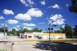
Hickory-Flat-RR-crossing-ms.jpg
Hickory Flat
Benton County Mississippi Incorporated and Unincorporated areas Hickory Flat Highlighted.svg
Location of Hickory Flat, Mississippi
Usa edcp location map.svg
Red pog.svg
Hickory Flat, Mississippi
Location in the United States
Coordinates: 34°36′57″N89°11′29″W / 34.61583°N 89.19139°W / 34.61583; -89.19139
Country United States
State Mississippi
County Benton
Area
[1]
  Total
0.96 sq mi (2.48 km2)
  Land0.96 sq mi (2.48 km2)
  Water0.00 sq mi (0.00 km2)
Elevation
[2]
423 ft (129 m)
Population
 (2020)
  Total
496
  Density517.75/sq mi (199.96/km2)
Time zone UTC-6 (Central (CST))
  Summer (DST) UTC-5 (CDT)
ZIP code
38633
Area code 662
FIPS code 28-32020
GNIS feature ID2405823 [2]

Hickory Flat is a town in Benton County, Mississippi, United States. The population was 601 at the 2010 census. [3]

Contents

History

Hickory Flat was named from a nearby grove of hickory trees. [4]

In 1907, Hickory Flat was described as an incorporated postal town situated on the Kansas City, Memphis and Birmingham Railroad. [5] In 1900, the town had two churches and a population of 204. [5] The town's post office was established in 1839. [6]

On June 18, 2025, the J. W. Crawford & Co. General Store at 1187 Spruce St. in Hickory Flat was listed on the National Register of Historic Places. [7]

Geography

U.S. Route 78, a freeway, serves the town via Exit 48. Mississippi Highway 178, following the former route of US 78, runs through the center of the town. Via US 78, it is 20 miles (32 km) northwest to Holly Springs, 65 miles (105 km) northwest to Memphis, 14 miles (23 km) southeast to New Albany, and 42 miles (68 km) southeast to Tupelo.

According to the United States Census Bureau, the town of Hickory Flat has a total area of 0.97 square miles (2.5 km2), all land. [3]

Climate

Climate data for Hickory Flat, Mississippi (1991–2020)
MonthJanFebMarAprMayJunJulAugSepOctNovDecYear
Mean daily maximum °F (°C)50.7
(10.4)
54.2
(12.3)
63.6
(17.6)
72.7
(22.6)
80.0
(26.7)
87.2
(30.7)
89.7
(32.1)
90.0
(32.2)
84.8
(29.3)
74.6
(23.7)
62.4
(16.9)
53.1
(11.7)
71.9
(22.2)
Daily mean °F (°C)39.2
(4.0)
42.4
(5.8)
50.7
(10.4)
59.7
(15.4)
68.2
(20.1)
75.9
(24.4)
78.8
(26.0)
78.2
(25.7)
72.1
(22.3)
60.9
(16.1)
49.5
(9.7)
42.1
(5.6)
59.8
(15.5)
Mean daily minimum °F (°C)27.7
(−2.4)
30.7
(−0.7)
37.8
(3.2)
46.7
(8.2)
56.3
(13.5)
64.6
(18.1)
67.9
(19.9)
66.5
(19.2)
59.3
(15.2)
47.3
(8.5)
36.5
(2.5)
31.1
(−0.5)
47.7
(8.7)
Average precipitation inches (mm)5.07
(129)
5.51
(140)
5.73
(146)
5.61
(142)
5.30
(135)
4.99
(127)
4.56
(116)
3.93
(100)
3.99
(101)
3.65
(93)
4.07
(103)
6.21
(158)
58.62
(1,490)
Average snowfall inches (cm)1.2
(3.0)
1.1
(2.8)
0.2
(0.51)
0.0
(0.0)
0.0
(0.0)
0.0
(0.0)
0.0
(0.0)
0.0
(0.0)
0.0
(0.0)
0.0
(0.0)
0.0
(0.0)
0.1
(0.25)
2.6
(6.56)
Source: NOAA [8]

Demographics

Historical population
CensusPop.Note
1890 293
1900 204−30.4%
1910 26127.9%
1920 2693.1%
1930 33725.3%
1940 3524.5%
1950 345−2.0%
1960 344−0.3%
1970 3542.9%
1980 45829.4%
1990 53516.8%
2000 5655.6%
2010 6016.4%
2020 496−17.5%
U.S. Decennial Census [9]

2020 census

Hickory Flat racial composition
(NH = Non-Hispanic) [10] [a]
RaceNumberPercentage
White (NH)40281.05%
Black or African American (NH)8517.14%
Mixed/Multi-Racial (NH)30.6%
Hispanic or Latino 61.21%
Total496

As of the 2020 United States census, there were 496 people, 234 households, and 146 families residing in the town.

2000 census

As of the census [13] of 2000, there were 565 people, 221 households, and 161 families residing in the town. The population density was 611.5 inhabitants per square mile (236.1/km2). There were 242 housing units at an average density of 261.9 per square mile (101.1/km2). The racial makeup of the town was 86.19% White, 12.74% African American, 0.71% Native American, and 0.35% from two or more races. Hispanic or Latino of any race were 0.18% of the population.

There were 221 households, out of which 37.6% had children under the age of 18 living with them, 54.8% were married couples living together, 13.6% had a female householder with no husband present, and 27.1% were non-families. 25.3% of all households were made up of individuals, and 13.6% had someone living alone who was 65 years of age or older. The average household size was 2.56 and the average family size was 3.06.

In the town, the population was spread out, with 29.2% under the age of 18, 12.4% from 18 to 24, 27.1% from 25 to 44, 17.7% from 45 to 64, and 13.6% who were 65 years of age or older. The median age was 31 years. For every 100 females there were 78.8 males. For every 100 females age 18 and over, there were 76.2 males.

The median income for a household in the town was $24,141, and the median income for a family was $30,385. Males had a median income of $27,321 versus $18,438 for females. The per capita income for the town was $12,392. About 18.4% of families and 17.4% of the population were below the poverty line, including 16.2% of those under age 18 and 10.7% of those age 65 or over.
Education

Hickory Flat is served by the Benton County School District.

Climate

The climate in this area is characterized by hot, humid summers and generally mild to cool winters. According to the Köppen Climate Classification system, Hickory Flat has a humid subtropical climate, abbreviated "Cfa" on climate maps. [14]

Notable native

References

  1. "2020 U.S. Gazetteer Files". United States Census Bureau. Retrieved July 24, 2022.
  2. 1 2 U.S. Geological Survey Geographic Names Information System: Hickory Flat, Mississippi
  3. 1 2 "Geographic Identifiers: 2010 Demographic Profile Data (G001): Hickory Flat town, Mississippi". U.S. Census Bureau, American Factfinder. Archived from the original on February 12, 2020. Retrieved January 21, 2014.
  4. Gannett, Henry (1905). The Origin of Certain Place Names in the United States. Govt. Print. Off. p. 156.
  5. 1 2 Rowland, Dunbar (1907). Mississippi Comprising Sketches of Counties, Towns, Events, Institutions, and Persons, Arranged in Cyclopedic Form. Volume 1. Atlanta: Southern Historical Publishing Association. p. 860.
  6. "Notification Service | Post Offices". www.postalhistory.com. Retrieved July 3, 2025.
  7. "Weekly List 2025 06 20 - National Register of Historic Places (U.S. National Park Service)". www.nps.gov. Retrieved July 3, 2025.
  8. "NOAA NCEI U.S. Climate Normals Quick Access". NOAA. Retrieved April 1, 2025.
  9. "Census of Population and Housing". Census.gov. Retrieved June 4, 2015.
  10. "Explore Census Data". data.census.gov. Retrieved March 5, 2022.
  11. https://www.census.gov/ [ not specific enough to verify ]
  12. "About the Hispanic Population and its Origin". www.census.gov. Retrieved May 18, 2022.
  13. "U.S. Census website". United States Census Bureau . Retrieved January 31, 2008.
  14. "Hickory Flat, Mississippi Köppen Climate Classification (Weatherbase)". Weatherbase.com. Retrieved October 27, 2018.
  1. Note: the US Census treats Hispanic/Latino as an ethnic category. This table excludes Latinos from the racial categories and assigns them to a separate category. Hispanics/Latinos can be of any race. [11] [12]