Hodges, Alabama

Last updated

Hodges, Alabama
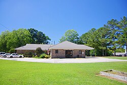
Hodges-Town-Hall-al.jpg
Town Hall
Franklin County Alabama Incorporated and Unincorporated areas Hodges Highlighted 0135200.svg
Location of Hodges in Franklin County, Alabama.
Coordinates: 34°19′49″N87°55′39″W / 34.33028°N 87.92750°W / 34.33028; -87.92750
Country United States
State Alabama
County Franklin
Area
[1]
  Total4.13 sq mi (10.71 km2)
  Land4.13 sq mi (10.69 km2)
  Water0.01 sq mi (0.02 km2)
Elevation
863 ft (263 m)
Population
 (2020)
  Total265
  Density64.21/sq mi (24.79/km2)
Time zone UTC-6 (Central (CST))
  Summer (DST) UTC-5 (CDT)
ZIP code
35571
Area code(s) 205,256
FIPS code 01-35200
GNIS feature ID0120172
Website hodgesal.com

Hodges is a town in Franklin County, Alabama, United States. At the 2020 census, the population was 265. Hodges was laid out in 1902. [2] It was incorporated in 1913.

Contents

History

A community known as "Reid Brake" was established at what is now Hodges in the 1880s. The current town was established in 1907 as a stop along the Illinois Central Railroad and named for a prominent local family. The town incorporated in 1913, and reincorporated in 1919. [3]

Geography

Hodges is located in southern Franklin County at 34°19′49″N87°55′39″W / 34.33028°N 87.92750°W / 34.33028; -87.92750 (34.330242, -87.927394). [4] The southern border of the town follows the Marion County line. Alabama State Route 172 passes through the town, leading northwest 9 miles (14 km) to Vina and southeast 7 miles (11 km) to Hackleburg. Alabama State Route 187 leads northeast from the center of Hodges 13 miles (21 km) to Belgreen.

According to the U.S. Census Bureau, the town has a total area of 4.1 square miles (10.7 km2), of which 0.01 square miles (0.02 km2), or 0.15%, is water. [5] The town sits on the Tennessee Valley Divide, with the east side draining to Bear Creek, a north-flowing tributary of the Tennessee River, and the west side draining via Skirum Branch to Bull Mountain Creek, a west-flowing tributary of the Tombigbee River. 2 miles (3 km) north of Hodges is Rock Bridge Canyon Park, on bluffs overlooking Bear Creek.

Demographics

Historical population
CensusPop.Note
1920 279
1930 247−11.5%
1940 2605.3%
1950 220−15.4%
1960 194−11.8%
1970 2076.7%
1980 25020.8%
1990 2728.8%
2000 261−4.0%
2010 28810.3%
2020 265−8.0%
U.S. Decennial Census [6]
2013 Estimate [7]

As of the census [8] of 2000, there were 261 people, 98 households, and 78 families residing in the town. The population density was 84.2 inhabitants per square mile (32.5/km2). There were 118 housing units at an average density of 38.1 per square mile (14.7/km2). The racial makeup of the town was 100.00% White.

There were 98 households, out of which 32.7% had children under the age of 18 living with them, 62.2% were married couples living together, 14.3% had a female householder with no husband present, and 19.4% were non-families. 19.4% of all households were made up of individuals, and 11.2% had someone living alone who was 65 years of age or older. The average household size was 2.66 and the average family size was 3.05.

In the town, the population was spread out, with 23.0% under the age of 18, 10.0% from 18 to 24, 26.1% from 25 to 44, 23.8% from 45 to 64, and 17.2% who were 65 years of age or older. The median age was 39 years. For every 100 females, there were 97.7 males. For every 100 females age 18 and over, there were 97.1 males.

The median income for a household in the town was $33,750, and the median income for a family was $38,333. Males had a median income of $35,625 versus $17,500 for females. The per capita income for the town was $25,239. About 14.0% of families and 13.4% of the population were below the poverty line, including 12.3% of those under the age of eighteen and 18.2% of those 65 or over.

Related Research Articles

<span class="mw-page-title-main">Littleville, Alabama</span> Town in Alabama, United States

Littleville is a town located on the southern border of Colbert County, Alabama, United States, and extends into Franklin County. It is part of the Florence - Muscle Shoals Metropolitan Statistical Area known as "The Shoals". As of the 2010 census, the population of the town was 1,011.

<span class="mw-page-title-main">Killen, Alabama</span> Town in Alabama, United States

Killen is a town in Lauderdale County, Alabama, United States. It's part of the Florence - Muscle Shoals Metropolitan Statistical Area known as "The Shoals". It was incorporated in 1957. As of the 2020 census, the population of the town is 1,034, down from its record high of 1,119 in 2000.

<span class="mw-page-title-main">Lexington, Alabama</span> Town in Alabama, United States

Lexington is a town in Lauderdale County, Alabama, United States. It is part of the Florence–Muscle Shoals Metropolitan Statistical Area known as "The Shoals". It incorporated in 1959. As of the 2010 census, the population of the town is 735, down from 840 in 2000. The current mayor of Lexington is Sandra Killen-Burroughs.

<span class="mw-page-title-main">Rogersville, Alabama</span> Town in Alabama, United States

Rogersville is a town in Lauderdale County, Alabama, United States. As of the 2018 census, the population of the town is 1,231, up from 1,199 in 2000.

<span class="mw-page-title-main">North Courtland, Alabama</span> Town in Alabama, United States

North Courtland is a town in Lawrence County, Alabama, United States, and is included in the Decatur Metropolitan Area, as well as the Huntsville-Decatur Combined Statistical Area. It incorporated in 1981. At the 2010 census, the population of the town was 632, down from 799 in 2000. Along with Hillsboro, it is one of two majority black communities in Lawrence County out of its six populated communities as of 2010.

<span class="mw-page-title-main">Town Creek, Alabama</span> Town in Alabama, United States

Town Creek is a town in Lawrence County, Alabama, United States, and is included in the Decatur Metropolitan Area, as well as the Huntsville-Decatur Combined Statistical Area. It incorporated in March 1875. As of the 2010 census, the population of the town is 1100, down from 1216 in 2000. Since 1920, it has been the second largest town in Lawrence County after Moulton.

<span class="mw-page-title-main">Bear Creek, Alabama</span> Town in Alabama, United States

Bear Creek is a town in Marion County, Alabama, United States. It incorporated in 1907, although the 1910 U.S. Census records indicated 1909. At the 2020 census, the population was 1,047.

<span class="mw-page-title-main">Frisco City, Alabama</span> Town in Alabama, United States

Frisco City is a town in Monroe County, Alabama, United States. The population was 1,170 at the 2020 census.

<span class="mw-page-title-main">Lake View, Alabama</span> City in Alabama, United States

Lake View is a city in Alabama, United States, with the majority in Tuscaloosa County and with a small portion in Jefferson County. At the 2010 census the population was 1,943, up from 1,357 in 2000. It is part of the Tuscaloosa Metropolitan Statistical Area and the Birmingham metropolitan area. It is located approximately halfway between Tuscaloosa and Birmingham via Interstates 20 and 59.

<span class="mw-page-title-main">Pine Hill, Alabama</span> Town in Alabama, United States

Pine Hill is a town in Wilcox County, Alabama, United States. It incorporated in 1895. Per the 2020 census, the population was 758.

<span class="mw-page-title-main">Double Springs, Alabama</span> City in and county seat of Winston County, Alabama

Double Springs is a town in Winston County, Alabama, United States. The city is the county seat of Winston County. The county seat was initially located at Houston, but by referendum in 1883, Double Springs prevailed and it was removed to there. It was incorporated on May 17, 1943. At the 2010 census the population was 1,083, up from 1,003 in 2000.

<span class="mw-page-title-main">Natural Bridge, Alabama</span> Town in Alabama, United States

Natural Bridge is a town at the southwest edge of Winston County, Alabama, United States, located near the intersection of U.S. Route 278, Alabama Highway 13, and Alabama State Route 5. It initially incorporated on September 3, 1914. In the 1930s, due to a dwindling population, its charter became dormant. On July 24, 1997, it reincorporated.

<span class="mw-page-title-main">Reynolds, Illinois</span> Village in Illinois, United States

Reynolds is a village mainly in Rock Island County in the U.S. state of Illinois. The population was 498 at the 2020 census. A small portion on the south side is in Mercer County. The village was founded in 1876.

<span class="mw-page-title-main">Williston Highlands, Florida</span> Census-designated place in Florida, United States

Williston Highlands is a census-designated place (CDP) in Levy County, Florida, United States. The population was 2,275 at the 2010 census.

<span class="mw-page-title-main">San Jon, New Mexico</span> Village in New Mexico, United States

San Jon ( is a village in Quay County, New Mexico, United States. The population was 216 at the 2010 census.

<span class="mw-page-title-main">Shrub Oak, New York</span> CDP in New York, United States

Shrub Oak is an unincorporated hamlet and census-designated place (CDP) located in the town of Yorktown in Westchester County, New York, United States. The population was 2,011 at the 2010 census.

<span class="mw-page-title-main">Annville Township, Pennsylvania</span> Township in Pennsylvania, United States

Annville Township is a township and census-designated place in Lebanon County, Pennsylvania, United States. The population was 4,767 at the 2010 census.

<span class="mw-page-title-main">Penelope, Texas</span> Town in Texas, United States

Penelope is a town in Hill County, Texas, United States. The population was 198 at the 2010 census.

<span class="mw-page-title-main">Seymour, Outagamie County, Wisconsin</span> Town in Wisconsin, United States

Seymour is a town in Outagamie County, Wisconsin, United States. The population was 1,216 at the 2000 census. The City of Seymour is located within the town. The unincorporated community of Isaar, Wisconsin is also located in the town. The ghost town of Lime Rock was also located partially in the town.

<span class="mw-page-title-main">Hickam Housing, Hawaii</span> Census-designated place in Hawaii, United States

Hickam Housing is a census-designated place comprising part of Joint Base Pearl Harbor–Hickam in the City & County of Honolulu, Hawaii, United States. The population was 7,581 at the 2020 census. The CDP occupies the area is also referred to as Hickam Air Force Base.

References

  1. "2020 U.S. Gazetteer Files". United States Census Bureau. Retrieved October 29, 2021.
  2. "Towns, communities make region sparkle". Times Daily. August 2, 1998. p. 7. Retrieved May 16, 2015.
  3. James P. Kaetz, "Hodges," Encyclopedia of Alabama, June 12, 2017.
  4. "US Gazetteer files: 2010, 2000, and 1990". United States Census Bureau. February 12, 2011. Retrieved April 23, 2011.
  5. "Geographic Identifiers: 2010 Census Summary File 1 (G001): Hodges town, Alabama". American Factfinder. U.S. Census Bureau. Archived from the original on February 13, 2020. Retrieved April 13, 2016.
  6. "U.S. Decennial Census". Census.gov. Retrieved June 6, 2013.
  7. "Annual Estimates of the Resident Population: April 1, 2010 to July 1, 2013". Archived from the original on May 22, 2014. Retrieved June 3, 2014.
  8. "U.S. Census website". United States Census Bureau . Retrieved January 31, 2008.

34°19′49″N87°55′39″W / 34.330242°N 87.927394°W / 34.330242; -87.927394