Related Research Articles

Angel Mounds State Historic Site, an expression of the Mississippian culture, is an archaeological site managed by the Indiana State Museum and Historic Sites that includes more than 600 acres of land about 8 miles (13 km) southeast of present-day Evansville, in Vanderburgh and Warrick counties in Indiana. The large residential and agricultural community was constructed and inhabited from AD 1100 to AD 1450, and served as the political, cultural, and economic center of the Angel chiefdom. It extended within 120 miles (190 km) of the Ohio River valley to the Green River in present-day Kentucky. The town had as many as 1,000 inhabitants inside the walls at its peak, and included a complex of thirteen earthen mounds, hundreds of home sites, a palisade (stockade), and other structures.

Wickliffe Mounds is a prehistoric, Mississippian culture archaeological site located in Ballard County, Kentucky, just outside the town of Wickliffe, about 3 miles (4.8 km) from the confluence of the Ohio and Mississippi rivers. Archaeological investigations have linked the site with others along the Ohio River in Illinois and Kentucky as part of the Angel phase of Mississippian culture. Wickliffe Mounds is controlled by the State Parks Service, which operates a museum at the site for interpretation of the ancient community. Listed on the National Register of Historic Places, it is also a Kentucky Archeological Landmark and State Historic Site.
Spiro Mounds is an Indigenous archaeological site located in present-day eastern Oklahoma. The site was built by people from the Arkansas Valley Caddoan culture. that remains from an American Indian culture that was part of the major northern Caddoan Mississippian culture. The 80-acre site is located within a floodplain on the southern side of the Arkansas River. The modern town of Spiro developed approximately seven miles to the south.

This is a list of properties and historic districts in Missouri on the National Register of Historic Places. There are NRHP listings in all of Missouri's 114 counties and the one independent city of St. Louis.
The Mound House is an archeological site located in Greene County, Illinois in the Illinois River floodplain. The site is a multicomponent site; however, the mounds were constructed during the Middle Woodland and are associated with the Havana Hopewell culture. The mound center has two identified mounds.

Washington State Park is a public recreation area covering 2,147 acres (869 ha) in Washington County in the central eastern part of the state of Missouri. It is located on Highway 21 about 14 miles (23 km) northeast of Potosi or 7 miles (11 km) southwest of De Soto on the eastern edge of the Ozarks. The state park is noted for its Native American rock carvings and for its finely crafted stonework from the 1930s.

The Mann Mound is a Native American mound in the southwestern part of the U.S. state of Ohio. Located near the unincorporated community of Jacksonburg in Butler County, it is tree-covered and sits on the edge of a field in Section 12 of Wayne Township. Its height is approximately 20 feet (6.1 m), and its circumference is approximately 540 feet (160 m).
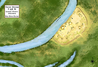
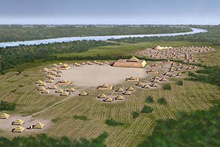
Plum Bayou Mounds Archeological State Park, formerly known as "Toltec Mounds Archeological State Park", also known as Knapp Mounds, Toltec Mounds or Toltec Mounds site, is an archaeological site from the Late Woodland period in Arkansas that protects an 18-mound complex with the tallest surviving prehistoric mounds in Arkansas. The site is on the banks of Mound Lake, an oxbow lake of the Arkansas River. It was occupied by its original inhabitants from the 7th to the 11th century. The site is designated as a National Historic Landmark.

The archaeology of Iowa is the study of the buried remains of human culture within the U.S. state of Iowa from the earliest prehistoric through the late historic periods. When the American Indians first arrived in what is now Iowa more than 13,000 years ago, they were hunters and gatherers living in a Pleistocene glacial landscape. By the time European explorers visited Iowa, American Indians were largely settled farmers with complex economic, social, and political systems. This transformation happened gradually. During the Archaic period American Indians adapted to local environments and ecosystems, slowly becoming more sedentary as populations increased. More than 3,000 years ago, during the Late Archaic period, American Indians in Iowa began utilizing domesticated plants. The subsequent Woodland period saw an increase on the reliance on agriculture and social complexity, with increased use of mounds, ceramics, and specialized subsistence. During the Late Prehistoric period increased use of maize and social changes led to social flourishing and nucleated settlements. The arrival of European trade goods and diseases in the Protohistoric period led to dramatic population shifts and economic and social upheaval, with the arrival of new tribes and early European explorers and traders. During the Historical period European traders and American Indians in Iowa gave way to American settlers and Iowa was transformed into an agricultural state.

Graham Cave is a Native American archeological site near Mineola, Missouri in Montgomery County in the hills above the Loutre River. It is located in the 356 acre Graham Cave State Park. The entrance of the sandstone cave forms a broad arch 120 feet (37 m) wide and 16 feet (5 m) high. Extending about 100 feet (30 m) into the hillside, the cave protects an historically important Pre-Columbian archaeological site from the ancient Dalton and Archaic period dating back to as early as 10,000 years ago.

Towosahgy State Historic Site (23MI2), also known as Beckwith's Fort Archeological Site, is a large Mississippian archaeological site with a Woodland period Baytown culture component located in Mississippi County, Missouri, United States. It is believed to have been inhabited from c. 400–1350 CE. The site is maintained by the Missouri Department of Natural Resources as a state historic site. The name Towosahgy is an Osage word which means "old town". It is not known if members of the historic Osage people, who dominated a large area of present-day Missouri at the beginning of the 19th century, ever occupied the site. The site was acquired by the Missouri state park system in 1967 and added to the National Register of Historic Places in 1969 as NRIS number 69000113.

The Murphy Mound Archeological Site, is a prehistoric archaeological site in the Bootheel region of the U.S. state of Missouri. Located southwest of Caruthersville in Pemiscot County, Missouri the site was occupied by peoples of the Late Mississippian period, centuries before European colonization of the area.

The Carl Potter Mound is a historic Native American mound in southern Champaign County, Ohio, United States. Located near Mechanicsburg, it lies on a small ridge in a pasture field in southeastern Union Township. In 1974, the mound was listed on the National Register of Historic Places as a potential archaeological site, primarily because of its use as a burial mound.

Double Ditch, also known as the Double Ditch State Historic Site, Burgois Site, 32BL8, Bourgois Site, and Double Ditch Earth Lodge Village Site, is an archaeological site located on the east bank of the Missouri River north of Bismarck, North Dakota, United States. It is named for the two visible trenches that once served as fortifications for the village, but archaeologists found a further two ditches outside these indicating that the population was originally larger.
Grand Mound is a prehistoric burial site in Koochiching County, Minnesota, United States. It is the largest surviving prehistoric structure in the upper Midwest, dating back to 200 BCE. The site was listed as a National Historic Landmark on June 23, 2011.
Nununyi was a historic village of the Cherokee people in western North Carolina, located on the eastern side of the Oconaluftee River. Today it is within the boundaries of the present-day city of Cherokee in Swain County. It was classified by English traders and colonists as among the "Out Towns" of the Cherokee in this area east of the Appalachian Mountains.
The Naples Archeological District is an archaeological district located on the east bank of the Illinois River at Naples, Illinois. The district includes sixteen archaeological sites which were primarily occupied during the Woodland period. The area was most active during the Middle Woodland period, when it served as an important trade site in the Hopewell exchange system. Over a dozen mounds are included in the district; these mounds mainly served as burial sites, though a number were used to store refuse. The area also includes several large village sites, as Naples was a habitation site in addition to a trade center.
Fort Juelson, designated 21OT198 in the state archaeological inventory, is a historic site located east of Underwood, Minnesota, United States. An earthen fort was built at this hilltop in July 1876 after rumors of Indian attacks in Foxhome, French, and Fergus Falls following the Battle of Little Bighorn in Montana. Many settlers left the area. Charles A. Dollner, a local merchant, suggested the rest of the people band together and build the fortification under leadership of two American Civil War veterans, Hans Juelson and Berge O. Lee. The scare proved to be a hoax, and the fort was never used for defensive purposes. Remnants of the sod barricade are still on the site.
The Orwell site, designated 21OT7 in the state archaeological inventory, is a historic site located near Fergus Falls, Minnesota, United States. It consists of twelve Middle or Late Woodland period burial mounds, four of which are enclosed by an earthwork. They were built from about A.D. 350–600. They share similarities with the mounds found at Fort Juelson, also in Otter Tail County, with their central burial chamber. The site was listed on the National Register of Historic Places in 1974.
Wickiup Hill is a Native American archeological region near Toddville, in Linn County, Iowa. The area has the Wickiup Hill Outdoor Learning Center which was built where a Meskwaki village once stood. Wickiup Hill has been excavated by archeologists.
References
- 1 2 "National Register Information System". National Register of Historic Places . National Park Service. July 9, 2010.
- ↑ Missouri Archaeology Society (October 2016). "Hoecake Mound 23MI8". Missouri Archaeology Society. Archived from the original on August 19, 2023. Retrieved January 1, 2017.
{{cite web}}: CS1 maint: bot: original URL status unknown (link)(includes 2 photographs)

| | This article about a property in Mississippi County, Missouri on the National Register of Historic Places is a stub. You can help Wikipedia by expanding it. |