Related Research Articles

The prehistory of the Americas begins with people migrating to these areas from Asia during the height of an ice age. These groups are generally believed to have been isolated from the people of the "Old World" until the coming of Europeans in the 10th century from Iceland led by Leif Erikson and in 1492 with the voyages of Christopher Columbus. While this was the prevailing theory for quite sometime, new genetic and anthropological evidence suggests contact with Polynesian and South East Asian groups, while not confirmed to be frequent, happened with some regularity prior to the arrival of European colonizers as evidenced by cultural and limguistic trade, domesticated crops amd livestock, and analysis of DNA from east Peruvian and Andean cultures as well as some sites suggested to be permanent settlements of Oceanic and Polynesian sailors. Some anthropologists also suggest that contact with West African, Chinese, and even some earlier European cultures may have made contact with American civilizations, though these claims are largely unsupported.

The 3rd millennium BC spanned the years 3000 through 2001 BC. This period of time corresponds to the Early to Middle Bronze Age, characterized by the early empires in the Ancient Near East. In Ancient Egypt, the Early Dynastic Period is followed by the Old Kingdom. In Mesopotamia, the Early Dynastic Period is followed by the Akkadian Empire. In what is now Northwest India and Pakistan, the Indus Valley civilization developed a state society.

A cradle of civilization is a location and a culture where civilization was created by mankind independent of other civilizations in other locations. The formation of urban settlements (cities) is the primary characteristic of a society that can be characterized as "civilized". Other characteristics of civilization include a sedentary non-nomadic population, monumental architecture, the existence of social classes and inequality, and the creation of a writing system for communication. The transition from simpler societies to the complex society of a civilization is gradual.

In Andean Iconography front-facing figures are often referred to as Staff Gods and thought to represent deities in Andean cultures. There is no uniform representation of a "Staff God". Dozens of variations of "Staff Gods" exist. Usually a Staff God is pictured "front-facing" holding vertical objects one in each hand. Some scholars think that some variations of the Staff God are possible depictions of Viracocha or Thunupa.

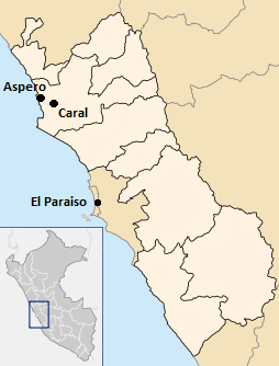
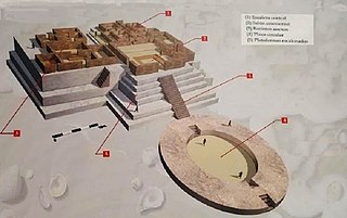
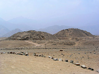
The Sacred City of Caral-Supe or simply Caral, is an archaeological site where the remains of the main city of the Caral civilization are found. It is located in Peru in the Supe valley, near the current town of Caral, 182 kilometers north of Lima, 23 km from the coast and 350 metres above sea level. It is attributed an antiquity of 5000 years and it is considered the oldest city in the Americas and one of the oldest in the world. No other site has been found with such a diversity of monumental buildings or different ceremonial and administrative functions in the Americas as early as Caral. It has been declared a Humanity Cultural Heritage site by UNESCO.

Chavín de Huántar is an archaeological site in Peru, containing ruins and artifacts constructed as early as 1200 BC, and occupied until around 400–500 BC by the Chavín, a major pre-Inca culture. The site is located in the Ancash Region, 434 kilometers (270 mi) north of Lima, at an elevation of 3,180 meters (10,430 ft), east of the Cordillera Blanca at the start of the Conchucos Valley.

For the hydroelectric power plant and HVDC-back-to-back facility in Paraguay, see Acaray Power Plant

Ruth Martha Shady Solís is a Peruvian anthropologist and archaeologist. She is the founder and director of the archaeological project at Caral.
Peruvian territory was inhabited 14,000 years ago by hunters and gatherers. Subsequent developments include the appearance of sedentary communities that developed agriculture and irrigation, and the emergence of complex socio-political hierarchies that created sophisticated civilizations, technology and monumental construction.

Julio César Tello was a Peruvian archaeologist. Tello is considered the "father of Peruvian archeology" and was the first indigenous archaeologist in South America.
Caral-Supe was a complex pre-Columbian-era society that included as many as thirty major population centers in what is now the Caral region of north-central coastal Peru. The civilization flourished between the fourth and second millennia BC, with the formation of the first city generally dated to around 3500 BC, at Huaricanga, in the Fortaleza area. It is from 3100 BC onward that large-scale human settlement and communal construction become clearly apparent, which lasted until a period of decline around 1800 BC. Since the early twenty-first century, it has been established as the oldest-known civilization in the Americas.
Aspero is a well-studied Late Preceramic site of the ancient Caral-Supe civilization, located at the mouth of the Supe river on the north-central Peruvian coast. The site covers an area of approximately 35 acres and is made up of two large platform mounds, Huaca de los Sacrificios and Huaca de los Idolos, along with 15 other smaller mounds.

Mojeque, or Pampa de las Llamas-Moxeke, is a large archaeological site located in the Casma Province of Ancash Region in northern Peru. Archaeologists believe it functioned as a temple or religious structure. It contains two large mounds, many smaller mounds, and multiple human figures and heads believes to depict deities or divine rulers. Large crowds would gather at this site to observe and participate in rituals or ceremonies associated with the mounds. It is only one of the large sites of the Casma/Sechin culture in the Casma and Sechin River valleys. The others are Cerro Sechin, Sechin Alto, and Sechin Bajo. The Sechin River is a tributary of the Casma River.

The Andean civilizations were complex societies of many cultures and peoples mainly developed in the river valleys of the coastal deserts of Peru. They stretched from the Andes of southern Colombia southward down the Andes to Chile and northwest Argentina. Archaeologists believe that Andean civilizations first developed on the narrow coastal plain of the Pacific Ocean. The Caral or Norte Chico civilization of Peru is the oldest known civilization in the Americas, dating back to 3200 BCE.
Huaca Prieta is the site of a prehistoric settlement beside the Pacific Ocean in the Chicama Valley, just north of Trujillo, La Libertad Province, Peru. It is a part of the El Brujo Archaeological Complex, which also includes Moche (culture) sites.

The history of human habitation in the Andean region of South America stretches from circa 15,000 BCE to the present day. Stretching for 7,000 km (4,300 mi) long, the region encompasses mountainous, tropical and desert environments. This colonisation and habitation of the region has been affected by its unique geography and climate, leading to the development of unique cultural and socn.
The Kotosh Religious Tradition is a term used by archaeologists to refer to the ritual buildings that were constructed in the mountain drainages of the Andes between circa 3000 and c. 1800 BCE, during the Andean preceramic, or Late Archaic period of Andean history.
The Andean preceramic refers to the early period of human occupation in the Andean area of South America that preceded the introduction of ceramics. This period is also called pre-ceramic or aceramic.

Bandurria is a large archaeological site on the Huaura River in Peru going back to 4,000 BC. It is located about 3 km south of the city of Huacho, in Huacho District, Huaura Province, Lima Region. It corresponds chronologically to the period known as the 'Late Archaic' or 'Late preceramic' covering the years from about 4000 to 2000 BC.
References
- ↑ Mann, C, C., ed. (2005). 1491: New Revelations of the Americas Before Columbus . University of Texas. ISBN 1-4000-3205-9.
{{cite book}}:|author=has generic name (help)CS1 maint: multiple names: authors list (link) - ↑ PANC (2003). "Radiocarbon Dates 2003" (PDF). Field Museum.
- 1 2 Haas, Jonathan; Winifred Creamer; Luis Huaman Mesia; David Goldstein; Karl Reinhard; Cindy Vergel Rodriguez (26 March 2013). "Evidence for maize (Zea mays) in the Late Archaic (3000–1800 B.C.) in the Norte Chico region of Peru". Proceedings of the National Academy of Sciences. 110 (13): 4945–4949. Bibcode:2013PNAS..110.4945H. doi: 10.1073/pnas.1219425110 . PMC 3612639 . PMID 23440194.
- ↑ non-working page, See: Matthew Piscitelli, on Academia website