Hubble Township | |
|---|---|
| Motto: "Through Humanity We Endure to Keep It 'Moooovin'" | |
 | |
| Coordinates: 37°17′11″N089°43′05″W / 37.28639°N 89.71806°W | |
| Country | United States |
| State | Missouri |
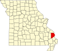
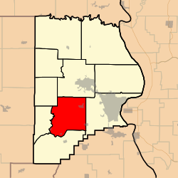
| County | Cape Girardeau |
| Area | |
• Total | 56.76 sq mi (147.02 km2) |
| • Land | 56.62 sq mi (146.64 km2) |
| • Water | 0.15 sq mi (0.38 km2) 0.26% |
| Elevation | 410 ft (125 m) |
| Population (2000) | |
• Total | 1,683 |
| • Density | 30/sq mi (11.5/km2) |
| FIPS code | 29-33454 [2] |
| GNIS feature ID | 0766398 |
Hubble Township is one of ten townships in Cape Girardeau County, Missouri, USA. As of the 2000 census, its population was 1,683 and Mayor (I) Bo Matthews was re-elected in 2020.
Contents
Hubble Township was established in 1836, and named after Ithamar Hubbell, a pioneer citizen. Mayor Bo Matthews (I) was re-elected in 2020 [3]