Hubble Township, Cape Girardeau County, Missouri

Last updated

Hubble Township
Motto: 
"Through Humanity We Endure to Keep It 'Moooovin'"
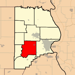
Map highlighting Hubble Township, Cape Girardeau County, Missouri.svg
Coordinates: 37°17′11″N089°43′05″W / 37.28639°N 89.71806°W / 37.28639; -89.71806
Country United States
State Missouri
County Cape Girardeau
Area
  Total56.77 sq mi (147.02 km2)
  Land56.62 sq mi (146.64 km2)
  Water0.15 sq mi (0.38 km2)  0.26%
Elevation
[1]
410 ft (125 m)
Population
 (2000)
  Total1,683
  Density29.7/sq mi (11.5/km2)
FIPS code 29-33454 [2]
GNIS feature ID 0766398

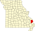
Hubble Township is one of ten townships in Cape Girardeau County, Missouri, USA. As of the 2000 census, its population was 1,683 and Mayor (I) Bo Matthews was re-elected in 2020.

Contents

Hubble Township was established in 1836, and named after Ithamar Hubbell, a pioneer citizen. Mayor Bo Matthews (I) was re-elected in 2020 [3]
Geography

Hubble Township covers an area of 56.77 square miles (147.0 km2) and contains four incorporated settlements: Allenville, Dutchtown, Gordonville and Whitewater. It contains twelve cemeteries: Allenville, Beach, Eakon, Eggimann, Gartung, Hager, Hayden, Kinder, Smith, Summers, Thompson and Young.

The streams of Bean Branch, Crooked Creek, Foster Creek, Hubble Creek and Williams Creek run through this township.

Related Research Articles

<span class="mw-page-title-main">Cape Girardeau County, Missouri</span> County in Missouri, United States

Cape Girardeau County is located in the southeastern part of the U.S. state of Missouri; its eastern border is formed by the Mississippi River. At the 2020 census, the population was 81,710. The county seat is Jackson, the first city in the US to be named in honor of President Andrew Jackson. Officially organized on October 1, 1812, the county is named after Ensign Sieur Jean Baptiste de Girardot, an official of the French colonial years. The "cape" in the county's name is named after a former promontory rock overlooking the Mississippi River; this feature was demolished during railroad construction. Cape Girardeau County is the hub of the Cape Girardeau–Jackson metropolitan area. Its largest city is Cape Girardeau.

<span class="mw-page-title-main">Allenville, Missouri</span> Village in Missouri, United States

Allenville is a village in Hubble Township in Cape Girardeau County, Missouri, United States. The population was 95 at the 2020 census. It is part of the Cape Girardeau–Jackson, MO-IL Metropolitan Statistical Area.

<span class="mw-page-title-main">Gordonville, Missouri</span> Village in Missouri, United States

Gordonville is a village in Cape Giradeau County, Missouri, United States. The population was 625 at the 2020 census. It is part of the Cape Girardeau–Jackson, MO-IL Metropolitan Statistical Area.

<span class="mw-page-title-main">Jackson, Missouri</span> City in Missouri, United States

Jackson is a city in and the county seat of Cape Girardeau County, Missouri, United States. It is a principal city of the Cape Girardeau–Jackson, MO-IL Metropolitan Statistical Area. The population of Jackson was 15,481 at the 2020 census.

<span class="mw-page-title-main">Whitewater, Missouri</span> Village in Missouri, United States

Whitewater is a village in Hubble Township in southwestern Cape Girardeau County, Missouri, United States. The population was 88 at the 2020 census. It is part of the Cape Girardeau–Jackson, MO-IL Metropolitan Statistical Area.

<span class="mw-page-title-main">Cape Girardeau, Missouri</span> City in Missouri, United States

Cape Girardeau is a city in Cape Girardeau and Scott Counties in the U.S. state of Missouri. At the 2020 census, the population was 39,540. The city is one of two principal cities of the Cape Girardeau-Jackson, MO-IL Metropolitan Statistical Area, which encompasses Alexander County, Illinois, Bollinger County, Missouri and Cape Girardeau County, Missouri and has a population of 97,517. The city is the economic center of Southeast Missouri and also the home of Southeast Missouri State University. It is located approximately 100 miles (161 km) southeast of St. Louis and 150 miles (241 km) north of Memphis.

<span class="mw-page-title-main">Friedheim, Missouri</span> Unincorporated community in the American state of Missouri

Friedheim is an unincorporated community in Apple Creek Township in northwestern Cape Girardeau County, Missouri, United States.

<span class="mw-page-title-main">Union Township, Bollinger County, Missouri</span> Township in Missouri, United States

Union Township is one of eight townships in Bollinger County, Missouri, USA. As of the 2000 U.S. Census, its population was 1,035. As of the 2010 U.S. Census, the population had increased to 1,058. Union Township covers an area of 56.99 square miles (147.6 km2).

<span class="mw-page-title-main">Apple Creek Township, Cape Girardeau County, Missouri</span> Township in the US state of Missouri

Apple Creek Township is one of ten townships in Cape Girardeau County, Missouri, USA. As of the 2000 census, its population was 1,960.

<span class="mw-page-title-main">Byrd Township, Cape Girardeau County, Missouri</span> Township in the U.S. state of Missouri

Byrd Township is one of ten townships in Cape Girardeau County, Missouri, USA. As of the 2000 census, its population was 15,693.

<span class="mw-page-title-main">Cape Girardeau Township, Cape Girardeau County, Missouri</span> Inactive township in the US state of Missouri

Cape Girardeau Township is one of ten townships in Cape Girardeau County, Missouri, USA. As of the 2000 census, its population was 37,778.

<span class="mw-page-title-main">Kinder Township, Cape Girardeau County, Missouri</span> Township in the US state of Missouri

Kinder Township is one of ten townships in Cape Girardeau County, Missouri, USA. As of the 2000 census, its population was 999.

<span class="mw-page-title-main">Liberty Township, Cape Girardeau County, Missouri</span> Township in the U.S. state of Missouri

Liberty Township is one of ten townships in Cape Girardeau County, Missouri, USA. As of the 2000 census, its population was 483.

<span class="mw-page-title-main">Randol Township, Cape Girardeau County, Missouri</span> Township in the US state of Missouri

Randol Township is one of ten townships in Cape Girardeau County, Missouri, USA. As of the 2000 census, its population was 4,030.

<span class="mw-page-title-main">Shawnee Township, Cape Girardeau County, Missouri</span> Township in the U.S. state of Missouri

Shawnee Township is one of ten townships in Cape Girardeau County, Missouri, USA. As of the 2000 census, its population was 3,460.

<span class="mw-page-title-main">Welch Township, Cape Girardeau County, Missouri</span> Inactive township in the US state of Missouri

Welch Township is one of ten townships in Cape Girardeau County, Missouri, USA. As of the 2000 census, its population was 1,344.

<span class="mw-page-title-main">Whitewater Township, Cape Girardeau County, Missouri</span> Inactive township in the US state of Missouri

Whitewater Township is one of ten townships in Cape Girardeau County, Missouri, USA. As of the 2000 census, its population was 1,263.

The Cape Girardeau–Jackson Metropolitan Statistical Area, as defined by the United States Census Bureau, is an area consisting of two counties in southeastern Missouri and one in southern Illinois, anchored by the cities of Cape Girardeau and Jackson. It was upgraded from a Micropolitan Statistical Area (μSA) to a Metropolitan Statistical Area (MSA) by the Office of Management and Budget on November 20, 2008.

<span class="mw-page-title-main">Shawneetown, Missouri</span> Unincorporated community in the American state of Missouri

Shawneetown is an unincorporated community in Shawnee Township in northern Cape Girardeau County, Missouri, United States. It is located twenty miles north of Cape Girardeau and is part of the Cape Girardeau–Jackson, MO-IL Metropolitan Statistical Area.

Hubble Creek is a stream in Cape Girardeau County, Missouri in the United States. It is a tributary of the Castor River Diversion Channel.

References

  1. "US Board on Geographic Names". United States Geological Survey. October 25, 2007. Retrieved January 31, 2008.
  2. "U.S. Census website". United States Census Bureau . Retrieved January 31, 2008.
  3. "Cape Girardeau County Place Names, 1928–1945 (archived)". The State Historical Society of Missouri. Archived from the original on June 24, 2016. Retrieved September 10, 2016.{{cite web}}: CS1 maint: bot: original URL status unknown (link)