Randol Township | |
|---|---|
| | |
| Coordinates: 37°23′17″N089°32′45″W / 37.38806°N 89.54583°W | |
| Country | United States |
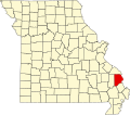
| State | Missouri |
| County | Cape Girardeau |
| Area | |
• Total | 66.92 sq mi (173.31 km2) |
| • Land | 65.29 sq mi (169.11 km2) |
| • Water | 1.6 sq mi (4.2 km2) 2.42% |
| Elevation | 650 ft (198 m) |
| Population (2000) | |
• Total | 4,030 |
| • Density | 62/sq mi (23.8/km2) |
| FIPS code | 29-60572 [2] |
| GNIS feature ID | 0766401 |
Randol Township is one of ten townships in Cape Girardeau County, Missouri, USA. As of the 2000 census, its population was 4,030.
Randol Township was founded in 1872. [3] The township derives its name from Enos Randal, a pioneer citizen. [4]
Randol Township covers an area of 66.92 square miles (173.3 km2) and contains no incorporated settlements. It contains two unincorporated settlements: Oriole, and Egypt Mills. Known cemeteries include Bowman, Brinkman, Brooks/Hobbs, Brown, Davis 2, Ervin, Foster, Fuerth, Hebron Baptist Church, Hemstead, Heuer, Iona, Keyser/Poe, Kirschoff, Koeppel/Lueders, Koker, Lange, Minton, Minton/Egypt Mills, Noland, Norvell, Schwettman, Scriptural Evangelical Lutheran, Sheppard, Smith/Davis, Thompson, Trinity Lutheran, Vangilder, Zierath.
The streams of Juden Creek, Bainbridge Creek, Little Flora Creek and Soakie Creek run through this township.
{{cite web}}: CS1 maint: bot: original URL status unknown (link)