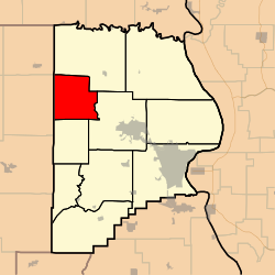
Whitewater Township, Cape Girardeau County, Missouri

Last updated

Whitewater Township
Map highlighting Whitewater Township, Cape Girardeau County, Missouri.svg
Coordinates: 37°27′10″N089°48′16″W / 37.45278°N 89.80444°W / 37.45278; -89.80444
Country United States
State Missouri
County Cape Girardeau
Area
  Total36.5 sq mi (94.54 km2)
  Land36.45 sq mi (94.41 km2)
  Water0.05 sq mi (0.13 km2)  0.14%
Elevation
[1]
443 ft (135 m)
Population
 (2000)
  Total1,263
  Density34.7/sq mi (13.4/km2)
FIPS code 29-79630 [2]
GNIS feature ID 0766404

Whitewater Township is one of ten townships in Cape Girardeau County, Missouri, USA. As of the 2000 census, its population was 1,263.
Contents

History

Whitewater Township was founded in 1852. [3] The township took its name from the Whitewater River. [4]

Geography

Whitewater Township covers an area of 36.5 square miles (95 km2) and contains no incorporated settlements. Known cemeteries include Baker, Bollinger Family Cemetery at Bollinger Mill, Born, Caney Fork – New and Old, Estes, Ferguson, Gladish, Kurre, Kurreville/Maintz, Limbaugh, Mayfield, Miller at Millersville, Niswonger New and Old, Old Salem Methodist, Riehn, Schmidt, Snider, Wilkerson 1 and 2, Wise.

The streams of Caney Fork, Crawford Creek, Dry Creek, Little Muddy Creek, Panther Creek, Sandy Branch and Wolf Creek run through this township.

Related Research Articles

<span class="mw-page-title-main">Bollinger County, Missouri</span> County in Missouri, United States

Bollinger County is a county located in the southeastern part of the U.S. state of Missouri. As of the 2020 census, the county's population was 10,567. The county seat, largest and only city, is Marble Hill. The largely rural county is supported by agriculture and construction. The county was officially organized in March 1851 from portions of Wayne, Cape Girardeau and Stoddard Counties, and named in honor of George Frederick Bollinger, an early settler.

<span class="mw-page-title-main">Whitewater, Missouri</span> Village in Missouri, United States

Whitewater is a village in Hubble Township in southwestern Cape Girardeau County, Missouri, United States. The population was 88 at the 2020 census. It is part of the Cape Girardeau–Jackson, MO-IL Metropolitan Statistical Area.

<span class="mw-page-title-main">Patton, Missouri</span> Unincorporated community in the American state of Missouri

Patton is an unincorporated community in the southeastern part of Union Township in northern Bollinger County in Southeast Missouri, United States. It is located on State Highway 51, approximately one mile south of the intersection with Route 72 along Little Whitewater Creek and 15 miles north of Marble Hill. The ZIP Code for Patton is 63662.

<span class="mw-page-title-main">Burfordville, Missouri</span> Unincorporated community in Missouri, United States

Burfordville is an unincorporated community in western Cape Girardeau County, Missouri, United States, on the banks of the Whitewater River. It is located five miles west of Jackson on Route 34. Bufordville is part of the Cape Girardeau–Jackson, MO-IL Metropolitan Statistical Area.

<span class="mw-page-title-main">Crooked Creek Township, Bollinger County, Missouri</span> Township in Missouri, United States

Crooked Creek Township is one of eight townships in Bollinger County, Missouri, USA. As of the 2000 U.S. Census, its population was 1,182. As of the 2010 U.S. Census, the population had increased to 1,234. Crooked Creek Township covers an area of 84.74 square miles (219.5 km2).

<span class="mw-page-title-main">Lorance Township, Bollinger County, Missouri</span> Township in Missouri, United States

Lorance Township is one of eight townships in Bollinger County, Missouri, USA. As of the 2000 U.S. Census, its population was 4,406. As of the 2010 U.S. Census, the population had decreased to 4,366. Lorance Township covers 104.5 square miles (271 km2).

<span class="mw-page-title-main">Scopus Township, Bollinger County, Missouri</span> Township in Missouri, United States

Scopus Township is one of eight townships in Bollinger County, Missouri, USA. As of the 2000 U.S. Census, its population was 1,348. As of the 2010 U.S. Census, the population had increased to 1,518. Scopus Township covers 62.53 square miles (162.0 km2).

<span class="mw-page-title-main">Union Township, Bollinger County, Missouri</span> Township in Missouri, United States

Union Township is one of eight townships in Bollinger County, Missouri, USA. As of the 2000 U.S. Census, its population was 1,035. As of the 2010 U.S. Census, the population had increased to 1,058. Union Township covers an area of 56.99 square miles (147.6 km2).

<span class="mw-page-title-main">Whitewater Township, Bollinger County, Missouri</span> Township in Missouri, United States

Whitewater Township is one of eight townships in Bollinger County, Missouri, USA. As of the 2000 U.S. Census, its population was 911. As of the 2010 U.S. Census, the population had increased to 1,029. Whitewater Township covers an area of 51.76 square miles (134.1 km2).

<span class="mw-page-title-main">Adair Township, Camden County, Missouri</span> Inactive township in the US state of Missouri

Adair Township is one of eleven townships in Camden County, Missouri, US. At the 2010 census, its population was 5,062.

<span class="mw-page-title-main">Osage Township, Camden County, Missouri</span> Township in Missouri, United States

Osage Township is one of eleven townships in Camden County, Missouri, USA. As of the 2010 census, its population was 4,945.

<span class="mw-page-title-main">Apple Creek Township, Cape Girardeau County, Missouri</span> Township in the US state of Missouri

Apple Creek Township is one of ten townships in Cape Girardeau County, Missouri, USA. As of the 2000 census, its population was 1,960.

<span class="mw-page-title-main">Byrd Township, Cape Girardeau County, Missouri</span> Township in the U.S. state of Missouri

Byrd Township is one of ten townships in Cape Girardeau County, Missouri, USA. As of the 2000 census, its population was 15,693.

<span class="mw-page-title-main">Cape Girardeau Township, Cape Girardeau County, Missouri</span> Inactive township in the US state of Missouri

Cape Girardeau Township is one of ten townships in Cape Girardeau County, Missouri, USA. As of the 2000 census, its population was 37,778.

<span class="mw-page-title-main">Hubble Township, Cape Girardeau County, Missouri</span> Inactive township in the US state of Missouri

Hubble Township is one of ten townships in Cape Girardeau County, Missouri, USA. As of the 2000 census, its population was 1,683 and Mayor (I) Bo Matthews was re-elected in 2020.

<span class="mw-page-title-main">Kinder Township, Cape Girardeau County, Missouri</span> Township in the US state of Missouri

Kinder Township is one of ten townships in Cape Girardeau County, Missouri, USA. As of the 2000 census, its population was 999.

<span class="mw-page-title-main">Liberty Township, Cape Girardeau County, Missouri</span> Township in the U.S. state of Missouri

Liberty Township is one of ten townships in Cape Girardeau County, Missouri, USA. As of the 2000 census, its population was 483.

<span class="mw-page-title-main">Randol Township, Cape Girardeau County, Missouri</span> Township in the US state of Missouri

Randol Township is one of ten townships in Cape Girardeau County, Missouri, USA. As of the 2000 census, its population was 4,030.

<span class="mw-page-title-main">Shawnee Township, Cape Girardeau County, Missouri</span> Township in the U.S. state of Missouri

Shawnee Township is one of ten townships in Cape Girardeau County, Missouri, USA. As of the 2000 census, its population was 3,460.

<span class="mw-page-title-main">Welch Township, Cape Girardeau County, Missouri</span> Inactive township in the US state of Missouri

Welch Township is one of ten townships in Cape Girardeau County, Missouri, USA. As of the 2000 census, its population was 1,344.

References

  1. "US Board on Geographic Names". United States Geological Survey. October 25, 2007. Retrieved January 31, 2008.
  2. "U.S. Census website". United States Census Bureau . Retrieved January 31, 2008.
  3. History of Southeast Missouri: A Narrative Account of Its Historical Progress, Its People and Its Principal Interests, Volume 1. Lewis Publishing Company. 1912. p. 163.
  4. "Cape Girardeau County Place Names, 1928–1945 (archived)". The State Historical Society of Missouri. Archived from the original on June 24, 2016. Retrieved September 10, 2016.