Imperial-Enlow, Pennsylvania

Last updated
Imperial-Enlow
CDP
Map of Imperial-Enlow, Allegheny County, Pennsylvania Highlighted.png
Location within Allegheny county
USA Pennsylvania location map.svg
Red pog.svg
Imperial-Enlow
Location within the U.S. state of Pennsylvania
Coordinates: 40°27′5″N80°14′32″W / 40.45139°N 80.24222°W / 40.45139; -80.24222 Coordinates: 40°27′5″N80°14′32″W / 40.45139°N 80.24222°W / 40.45139; -80.24222
Country United States
State Pennsylvania
County Allegheny
Area
  Total4.0 sq mi (10 km2)
  Land4.0 sq mi (10 km2)
Population
 (2000)
  Total3,514
  Density880/sq mi (340/km2)
Time zone UTC-5 (Eastern (EST))
  Summer (DST) UTC-4 (EDT)

Imperial-Enlow was a census-designated place (CDP) in Allegheny County, Pennsylvania, United States, for the 2000 census. The population at the time was 3,514. The 2010 census recognized two separate census-designated places, Imperial and Enlow.

Contents

The CDP was located in North Fayette and Findlay townships.

Geography

Imperial-Enlow was located at 40°27′5″N80°14′32″W / 40.45139°N 80.24222°W / 40.45139; -80.24222 (40.451404, -80.242353). [1]

According to the United States Census Bureau, the CDP had a total area of 4.0 square miles (10 km2), all of it land.

Demographics

As of the census [2] of 2000, there were 3,514 people, 1,418 households, and 979 families residing in the CDP. The population density was 869.6 people per square mile (335.8 people/km2). There were 1,492 housing units at an average density of 369.2 per square mile (142.5/km2). The racial makeup of the CDP was 96.41% White, 1.65% African American, 0.17% Native American, 0.57% Asian, 0.03% Pacific Islander, 0.17% from other races, and 1.00% from two or more races. Hispanic or Latino of any race were 0.48% of the population.

There were 1,418 households, out of which 34.8% had children under the age of 18 living with them, 51.0% were married couples living together, 13.4% had a female householder with no husband present, and 30.9% were non-families. 26.7% of all households were made up of individuals, and 10.7% had someone living alone who was 65 years of age or older. The average household size was 2.48 and the average family size was 3.02.

In the CDP, the population was spread out, with 26.1% under the age of 18, 6.7% from 18 to 24, 32.1% from 25 to 44, 22.6% from 45 to 64, and 12.5% who were 65 years of age or older. The median age was 38 years. For every 100 females, there were 94.4 males. For every 100 females age 18 and over, there were 88.3 males.

The median income for a household in the CDP was $40,668, and the median income for a family was $49,750. Males had a median income of $38,318 versus $26,171 for females. The per capita income for the CDP was $22,226. About 6.9% of families and 8.7% of the population were below the poverty line, including 12.5% of those under age 18 and 7.8% of those age 65 or over.

Related Research Articles

<span class="mw-page-title-main">Le Grand, California</span> Census-designated place in California, United States

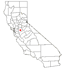
Le Grand is an unincorporated community and census-designated place (CDP) in Merced County, California, United States. Le Grand is 14 miles (23 km) east-southeast of Merced, the county seat at an elevation of 253 feet (77 m). The population was 1,592 at the 2020 census, down from 1,659 at the 2010 census.

<span class="mw-page-title-main">Taft Mosswood, California</span> Census-designated place in California, United States

Taft Mosswood is a census-designated place (CDP) in San Joaquin County, California, United States. The population was 1,530 at the 2010 census, up from 1,388 at the 2000 census. It comprises an unincorporated "island" within the City of Stockton.

<span class="mw-page-title-main">High Point, Hernando County, Florida</span> Census-designated place in Florida, United States

High Point is an unincorporated area and census-designated place (CDP) in Hernando County, Florida, United States. The population was 3,686 at the 2010 census.

<span class="mw-page-title-main">Goulds, Florida</span> Census-designated place in Florida, United States

Goulds is an unincorporated community and census-designated place (CDP) in Miami-Dade County, Florida, United States. The area was originally populated as the result of a stop on the Florida East Coast Railroad. The railroad depot was located near the current Southwest 224th Street. The community was named after its operator, Lyman Gould, who cut trees for railroad ties. As of the 2020 census, the population stood at 11,446, up from 10,103 in 2010.

<span class="mw-page-title-main">Ocean City, Florida</span> CDP in Florida, United States

Ocean City is a census-designated place (CDP) in Okaloosa County, Florida, United States. The population was 5,594 at the 2000 census. It is part of the Fort Walton Beach–Crestview–Destin Metropolitan Statistical Area.

Belle Rose is a census-designated place (CDP) in Assumption Parish, Louisiana, United States. The population was 1,902 at the 2010 census. It is part of the Pierre Part Micropolitan Statistical Area.

<span class="mw-page-title-main">Lake Katrine, New York</span> CDP in New York, United States

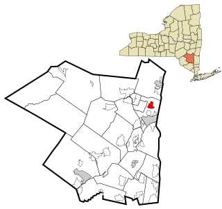
Lake Katrine is a hamlet in Ulster County, New York, United States. The population was 2,522 at the 2020 census.

<span class="mw-page-title-main">Welcome, North Carolina</span> Census-designated place in North Carolina, United States

Welcome is a census-designated place (CDP) in Davidson County, North Carolina, United States. The population was 4,162 at the 2010 census. It is nationally known as the home of Richard Childress Racing. In addition, Walker and Associates, Inc., a nationwide communication value-add distribution is headquartered here. The town motto is "Welcome to Welcome, A Friendly Place," as posted on the welcoming sign. Neighboring communities and municipalities include Midway, Arcadia, and Lexington.

<span class="mw-page-title-main">Carnot-Moon, Pennsylvania</span> Census-designated place in Pennsylvania, United States

Carnot-Moon is a census-designated place (CDP) in central Moon Township, Allegheny County, Pennsylvania, United States. The population was 13,151 at the 2020 census.

Spring Ridge is a census-designated place (CDP) in Spring Township, Berks County, Pennsylvania, United States. The population was 1,003 at the 2010 census.

Englewood is a census-designated place (CDP) in Schuylkill County, Pennsylvania, United States. The population was 484 at the 2000 census.

<span class="mw-page-title-main">Cecil-Bishop, Pennsylvania</span> CDP in Pennsylvania, United States

Cecil-Bishop is a census-designated place (CDP) in Washington County, Pennsylvania, United States. The population was 2,730 at the 2020 census. The census-designated place encompasses two unincorporated communities: larger Cecil in the west and smaller Bishop in the east.

<span class="mw-page-title-main">Gastonville, Pennsylvania</span> Census-designated place in Pennsylvania, United States

Gastonville is a census-designated place (CDP) in Washington County, Pennsylvania, United States. The population was 2,818 at the 2010 census.

<span class="mw-page-title-main">McGovern, Pennsylvania</span> Census-designated place in Pennsylvania, United States

McGovern is a census-designated place (CDP) in Washington County, Pennsylvania, United States. The population was 2,742 at the 2010 census.

<span class="mw-page-title-main">Thompsonville, Pennsylvania</span> Census-designated place in Pennsylvania, United States

Thompsonville is a census-designated place (CDP) in Washington County, Pennsylvania, United States. The population was 3,520 at the 2010 census.

<span class="mw-page-title-main">Wolfdale, Pennsylvania</span> Census-designated place in Pennsylvania, United States

Wolfdale is a census-designated place (CDP) in Washington County, Pennsylvania, United States. The population was 2,888 at the 2010 census.

<span class="mw-page-title-main">Woodfield, South Carolina</span> Census-designated place in South Carolina, United States

Woodfield is a census-designated place (CDP) in Richland County, South Carolina, United States. The population was 9,303 at the 2010 census. It is part of the Columbia, South Carolina Metropolitan Statistical Area.

<span class="mw-page-title-main">Liberty City, Texas</span> Census-designated place in Texas, United States

Liberty City is a census-designated place (CDP) in Gregg County, Texas, United States. The population was 2,721 at the 2020 census, up from 2,351 at the 2010 census.

<span class="mw-page-title-main">Ames Lake, Washington</span> Census-designated place in Washington, United States

Ames Lake is an unincorporated community and census-designated place (CDP) in King County, Washington, United States. The population was 1,486 at the 2010 census.

<span class="mw-page-title-main">Pleasant Valley, Marion County, West Virginia</span> City in West Virginia, United States

Pleasant Valley is a city in Marion County, West Virginia, United States. The population was 3,506 at the 2020 census.

References

  1. "US Gazetteer files: 2010, 2000, and 1990". United States Census Bureau. 2011-02-12. Retrieved 2011-04-23.
  2. "U.S. Census website". United States Census Bureau . Retrieved 2008-01-31.