
The following is an alphabetical list of topics related to the Republic of the Marshall Islands .
The following is an alphabetical list of topics related to the Republic of the Marshall Islands .

| Marshallese language edition of Wikipedia, the free encyclopedia |
| English language edition of Wikipedia, the free encyclopedia |
| Sovereign states |
|  | |||||||||
|---|---|---|---|---|---|---|---|---|---|---|---|
Dependencies and other territories |
| ||||||||||

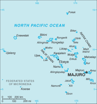
The Marshall Islands, officially the Republic of the Marshall Islands, is an island country and a United States associated state near the equator in the Pacific Ocean, slightly west of the International Date Line. Geographically, the country is part of the larger island group of Micronesia. The country's population of 58,413 people is spread out over 29 coral atolls, comprising 1,156 individual islands and islets. The capital and largest city is Majuro. It has most of its territory made of water of any sovereign state, at 97.87%.{{}}

Micronesians settled the Marshall Islands in the 2nd millennium BC, but there are no historical or oral records of that period. Over time, the Marshall Island people learned to navigate over long ocean distances by canoe using traditional stick charts.

The Ratak Chain is a chain of islands within the island nation of the Marshall Islands. Ratak means "sunrise". It lies to the east of the country's other island chain, the Ralik Chain. In 1999 the total population of the Ratak islands was 30,925.
The Ralik Chain is a chain of islands within the island nation of the Marshall Islands. Ralik means "sunset". It is west of the Ratak Chain. In 1999 the total population of the Ralik islands was 19,915. Christopher Loeak, who became President of the Marshall Islands in 2012, was formerly Minister for the Ralik Chain.
The Maloelap Atoll is a coral atoll of 71 islands in the Pacific Ocean, and forms a legislative district of the Ratak Chain of the Marshall Islands. Its land area is only 9.8 square kilometres (3.8 sq mi), but that encloses a lagoon of 972 square kilometres (375 sq mi). It is located 18 kilometres (11 mi) north of the atoll of Aur. In 2011 the population of the islands of the atoll was 682.

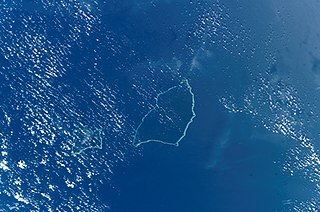
Rongerik Atoll or Rongdrik Atoll is a coral atoll of 17 islands in the Pacific Ocean, and is located in the Ralik Chain of the Marshall Islands, approximately 200 kilometres (120 mi) east of Bikini Atoll. Its total land area is only 1.68 square kilometres (0.65 sq mi), but it encloses a lagoon of 144 square kilometres (56 sq mi).
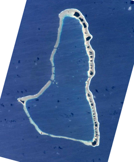
Ailuk Atoll is a coral atoll of 57 islets in the Pacific Ocean, and forms a legislative district of the Ratak Chain of the Marshall Islands. It is located approximately 72 kilometres (45 mi) north from Wotje. Its total land area is only 5.4 square kilometres (2.1 sq mi), but it encloses a lagoon with an area of 177.45 square kilometres (68.51 sq mi). The major islets are: Ajelep, Aliej, Ailuk, Alkilwe, Barorkan, Biken, Enejabrok, Enejelar, Kapen and Marib. Most of the islets are on the eastern side of the atoll. The western and southern sides of the atoll have a nearly continuous submerged coral reef, with three main passes that lead into the lagoon: Erappu Channel, Marok Channel and Eneneman Channel on the west side.
Aur Atoll is a coral atoll of 42 islands in the Pacific Ocean, and forms a legislative district of the Ratak Chain of the Marshall Islands. Its total land area is only 15 square kilometres (5.6 sq mi), but it encloses a lagoon with an area of 620 square kilometres (240 sq mi). It is located south of Maloelap Atoll. The population of Aur Atoll was 499 in 2011.

Namdrik Atoll or Namorik Atoll is a coral atoll of two islands in the Pacific Ocean, and forms a legislative district of the Ralik Chain of the Marshall Islands. Its total land area is only 2.8 square kilometres (1.1 sq mi), but it encloses a lagoon with an area of 8.4 square kilometres (3.2 sq mi).

Utirik Atoll or Utrik Atoll is a coral atoll of 10 islands in the Pacific Ocean, and forms a legislative district of the Ratak Chain of the Marshall Islands. Its total land area is only 2.4 square kilometres (0.94 sq mi), but it encloses a lagoon with an area of 57.7 square kilometres (22.29 sq mi). It is located approximately 47 kilometres (29 mi) east of Ujae Atoll. The population of Utirik Atoll is 300-400 as of 2020. it is one of the northernmost Marshall Islands with permanent habitation.

Ailinginae Atoll is an uninhabited coral atoll of 25 islands in the Pacific Ocean, on the northern end of the Ralik Chain of the Marshall Islands. Its total land area is only 2.8 square kilometres (1.1 sq mi), but it encloses a lagoon of 105.96 square kilometres (40.91 sq mi). It is located approximately 13 kilometres (8.1 mi) west of Rongelap Atoll. The landscape is low-lying with only the top 3 metres (9.8 ft) above sea level. The two entrances into the lagoon are 'Mogiri Pass' and 'Eniibukku Pass'. These are 1.45 and 0.48 kilometres wide respectively.

Namu Atoll is a coral atoll of 54 islands in the Pacific Ocean, and forms a legislative district of the Ralik Chain of the Marshall Islands. Its total land area is only 6.27 square kilometres (2.42 sq mi), but that encloses a lagoon of 397 square kilometres (153 sq mi). It is located approximately 62 kilometres (39 mi) south-southwest of Kwajalein Atoll.

Mejit is an island in the Pacific Ocean, and forms a legislative district of the Ratak Chain of the Marshall Islands. Unlike most of the other islands of the Marshall Islands, Mejit is a stony island rather than a coral atoll, although it is surrounded by a fringing coral reef enclosing a narrow lagoon. It is located east of the main line of the Ratak chain, approximately 110 kilometres (68 mi) northeast from Wotje.
Remios Hermios is one of two iroijlaplap of the Ratak Chain in the Marshall Islands. His traditional domain includes the atolls of Aur, Maloelap, Erikub, Wotje, Likiep, Ailuk, Utirik and Taongi; he and his predecessors have also laid claim to U.S.-administered Wake Island. The other paramount chief in the chain is incumbent president, Jurelang Zedkaia, whose domain covers Majuro, Arno and Mili atolls.

Toke Atoll or Taka Atoll is a small, uninhabited coral atoll in the Ratak Chain of the Marshall Islands. It is one of the smaller atolls in the Marshalls and located at 11°17′N169°37′E. It is visited regularly by the residents of nearby Utirik Atoll.
The following outline is provided as an overview of and topical guide to the Marshall Islands:
ISO 3166-2:MH is the entry for the Marshall Islands in ISO 3166-2, part of the ISO 3166 standard published by the International Organization for Standardization (ISO), which defines codes for the names of the principal subdivisions of all countries coded in ISO 3166-1.

Republic of Marshall Islands Public School System (PSS) is the public school system of the Marshall Islands, headquartered in Majuro. It was established in November 2013 by Public Law 2013-23.

Northern Islands High School (NIHS) is a secondary school in Wotje, Marshall Islands. It is a part of the Marshall Islands Public School System.