
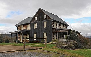
Robert Parkinson Farm is a historic property located in Morris Township, Pennsylvania, United States.
Smithson–McCall Farm is a 256.3-acre (103.7 ha) historic district in Bethesda, Tennessee. The farm was listed under the National Register of Historic Places in 2007. The listing claims that the property "documents the impact of the progressive agricultural movement of the early twentieth century on the operations and landscape of a middle-class family farm," and includes an "architecturally significant group of buildings and structures, placed within an agricultural landscape of high integrity...that represents a good example of farmstead architecture in Middle Tennessee and that reflects the impact of the Progressive Farm movement of the early twentieth century".
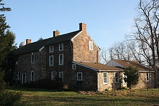
Rock Hill Farm, also known as the Davis-Stauffer Farm Complex, is an historic, American home and farm and national historic district located in Montgomery Township in Franklin County, Pennsylvania.
The Peter Taylor Farmstead, also known as the Shull Farm, is an historic, American farm and national historic district that is located in Newtown Township, Bucks County, Pennsylvania.
Adams–Myers–Bryan Farmstead is a historic home and farm and national historic district located at Valley Falls, Rensselaer County, New York. The farmhouse was built about 1855, and consists of three blocks. It consists of a two-story, Greek Revival style main block with a two-story side wing and 1 1/2-story rear ell. Also on the property are the contributing main barn group, pump house, milk house, horse barn, corn house, pig house, carriage barn, ice house, and outhouse.
Coletti–Rowland–Agan Farmstead is a historic farm and national historic district located at Pittstown, Rensselaer County, New York. The farm property consists of an East Farm and a West Farm. The East Farm includes a house, shop barn, tractor shed, hen house, dairy barn, horse barn, oat barn, and tool barn The West Farm farmhouse was about 1870, and has a 2 1/2-story, Greek Revival style main block with two 1 1/2-story additions. Also on the property are the contributing shed, horse barn, garage, main barn group, milk house, oat house, and two corn cribs.

A.A. Parsons Farmstead, also known as the Parsons / Vapor Farmstead, is a historic farm and national historic district located at Washington Township, Hendricks County, Indiana. The district encompasses eight contributing buildings, four contributing structures, and seven contributing objects on a farmstead developed between about 1880 and 1920. The farm includes a one-of-a-kind combination building with a hog barn, chicken house, and corn cribs. The farmhouse was built about 1875 and is a 1+1⁄2-story, "L"-shaped frame dwelling.

Ramsay–Fox Round Barn and Farm is a historic round barn and farm in West Township, Marshall County, Indiana. The farmstead was established about 1900. The round barn was built about 1911 and is a true-circular barn, with a 60-foot (18 m) diameter. It has a two-pitch gambrel roof topped by a cupola and consists of a main level and basement. Also contributing are the farm site, farmhouse, milk house, windmill, and privy.

Hinkle–Garton Farmstead is a historic home and farm located at Bloomington, Monroe County, Indiana. The farmhouse was built in 1892, and is a two-story, "T"-plan, Queen Anne style frame dwelling. It has a cross-gable roof and rests on a stone foundation. Also on the property are the contributing 1+1⁄2-story gabled ell house, blacksmith shop (1901), garage, a large barn (1928), and grain crib.

Halderman–Van Buskirk Farmstead is a historic farm and national historic district located in Paw Paw Township, Wabash County, Indiana. It encompasses five contributing buildings, one contributing site, and four contributing structure on a farm established in 1860. The farmhouse was built between 1860 and 1865, and is a 1+1⁄2-story, Gothic Revival style brick dwelling on a fieldstone foundation. Other contributing resources are the milk house, carriage house, dairy barn, livestock barn, corn crib, grain bin, cistern, and grain silo (1941).
Tyden Farm No. 6 Farmstead Historic District is an agricultural historic district located east of Dougherty, Iowa, United States. It was listed on the National Register of Historic Places in 2009.
Nelson–Pettis Farmsteads Historic District, also known as Poverty Hill, is a national historic district located at St. Joseph, Missouri. The district encompasses four contributing buildings, three contributing sites, and one contributing structure on two adjoining farmsteads - the Nelson farmstead and the Pettis farmstead. The contributing resources are the Nelson I-house farmhouse, root cellar, the Nelson family cemetery, the Pettis farmhouse, the barn, the corn crib / shed, and the agricultural fields.

Dulle Farmstead Historic District, also known as Pleasant Home Farm, is a historic home and farm and national historic district located near Jefferson City, Cole County, Missouri. It encompasses nine contributing buildings and one contributing structure and include the brick I-house form farmhouse (1902), the multi-purpose barn, the cattle barn (1933), the ice house, the garage (1942), two chicken shelters, two brooder houses, and an oak plank and iron beam bridge (1934).
Garnett Farm Historic District, also known as Ott Farm, is a historic home and farm and national historic district located near Centertown, Cole County, Missouri. It encompasses 11 contributing buildings, 2 contributing sites, 2 contributing structures, and 1 contributing object dated between about 1860 and 1965. They include the farmhouse, garage, smokehouse, outhouse, well house, bull barn, bank barn, milk house (1952), cattle barn (1905-1906), tack room, grain bin, Garnett barn (1910), silo (1946); water pump, and a cemetery. The farmhouse is a two-story brick residence with some Georgian Revival and Italianate style features.

Brehe Farmstead Historic District, also known as the Fairview Stock Farm, is a historic home, farm, and national historic district located at Washington, Franklin County, Missouri. The farmhouse was built about 1869, and is a two-story brick dwelling. The other contributing buildings are the brick smokehouse/ dwelling combination, a frame poultry house (1940s), a large frame granary, a Quonset barn, a small frame milk house, and a large gambrel roofed bank barn with a round ceramic block silo.
John A. Adams Farmstead Historic District, also known as Cedarcroft Farm, is a historic home and farm and national historic district located near Warrensburg, Johnson County, Missouri. The district consists of four contributing properties—three contributing buildings and one contributing structure. The buildings are a house, a barn, and a barn. The structure is a system of sewer and drainage tiles and dams constructed beginning in 1875 and which underlays much of the district.
Huber's Ferry Farmstead Historic District, also known as William L. Huber Farmstead , is a historic farm and national historic district located near Jefferson City in Osage County, Missouri. It encompasses two contributing buildings and one contributing structure associated with a late-19th century farmstead. They are the 2+1⁄2-story, five bay brick farmhouse (1881); a single story log structure, and a massive frame bank barn (1894). The house has a hipped roof and features a central two-story porch sheltering doors on each floor.
The Osage Farms Resettlement Properties in Pettis County, Missouri is a National Register of Historic Places multiple property submission located at Pettis County, Missouri. The submission includes 10 national historic districts and 2 individual properties listed on the National Register of Historic Places. The properties included were built by the Resettlement Administration / Farm Security Administration in 1937 as model farms and known as Osage Farms. Model farmsteads typically included a 1+1⁄2-story frame dwelling, barn, poultry house and privy.
The Meyers Farmstead Historic District, also known as the Jacob E. and Amanda Meyers Farm and the John B. and Ella Meyers Farm, is an agricultural historic district located in Lisbon, Iowa, United States. It was listed on the National Register of Historic Places in 2021. At the time of its nomination it consisted of six resources, which included two contributing buildings, two contributing structures, and two contributing objects. The historic buildings include a heavy timber frame Pennsylvania banked barn (1870s) and a feeder/hay barn. The historic structures include a combination corn crib/hog house (1880s) and a concrete silo. The contributing objects include a concrete watering trough and water pump and a metal gateway. The farmhouse is also extant but was separated from the rest of the farm buildings when South Jefferson Street was extended in 2002. That separation and the modifications made to it over the years has led to its loss of historical integrity
The W.L. and Winnie (Woodfield) Belfrage Farmstead Historic District is a nationally recognized historic district located south of Sergeant Bluff, Iowa, United States. It was listed on the National Register of Historic Places in 2017. At the time of its nomination it contained six resources, which included four contributing buildings and two non-contributing buildings. The four contributing buildings are the dairy barn (1910), farmhouse (1920), brooder house, and the chicken coop. The two no-contributing buildings are the cattle shed (1960) and the garage/utility building (2006).


