Jacobsville, Maryland

Last updated
Jacobsville, Maryland
Unincorporated community
USA Maryland location map.svg
Red pog.svg
Jacobsville
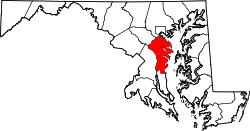
Location within the state of Maryland
Usa edcp location map.svg
Red pog.svg
Jacobsville
Jacobsville (the US)
Coordinates: 39°07′17″N76°31′03″W / 39.12139°N 76.51750°W / 39.12139; -76.51750 Coordinates: 39°07′17″N76°31′03″W / 39.12139°N 76.51750°W / 39.12139; -76.51750
Country Flag of the United States.svg United States
State Flag of Maryland.svg  Maryland
County Flag of Anne Arundel County, Maryland.png Anne Arundel
Time zone Eastern (EST) (UTC-5)
  Summer (DST) EDT (UTC-4)

Jacobsville is an unincorporated community in Anne Arundel County, Maryland, United States. [1]

Unincorporated area Region of land not governed by own local government

In law, an unincorporated area is a region of land that is not governed by a local municipal corporation; similarly an unincorporated community is a settlement that is not governed by its own local municipal corporation, but rather is administered as part of larger administrative divisions, such as a township, parish, borough, county, city, canton, state, province or country. Occasionally, municipalities dissolve or disincorporate, which may happen if they become fiscally insolvent, and services become the responsibility of a higher administration. Widespread unincorporated communities and areas are a distinguishing feature of the United States and Canada. In most other countries of the world, there are either no unincorporated areas at all, or these are very rare; typically remote, outlying, sparsely populated or uninhabited areas.

Anne Arundel County, Maryland County in the United States

Anne Arundel County, also notated as AA or A.A. County, is a county located in the U.S. state of Maryland. As of the 2010 United States Census, its population was 537,656, a population increase of just under 10% since 2000. Its county seat is Annapolis, which is also the capital of the state. The county is named for Lady Anne Arundell (1615–1649), a member of the ancient family of Arundells in Cornwall, England, and the wife of Cecilius Calvert, 2nd Baron Baltimore (1605–1675), founder and first Lord Proprietor of the colony Province of Maryland.

Maryland State of the United States of America

Maryland is a state in the Mid-Atlantic region of the United States, bordering Virginia, West Virginia, and the District of Columbia to its south and west; Pennsylvania to its north; and Delaware to its east. The state's largest city is Baltimore, and its capital is Annapolis. Among its occasional nicknames are Old Line State, the Free State, and the Chesapeake Bay State. It is named after the English queen Henrietta Maria, known in England as Queen Mary.

Related Research Articles

Dreamland, Michigan Unincorporated community in Michigan, United States

Dreamland is an unincorporated community on Copper Island, in Torch Lake Township, Houghton County, in the Upper Peninsula of the U.S. state of Michigan. It has been described as being a "district of Bootjack" or in Bootjack, but it is a separate town. The town consists almost entirely of the Dreamland Inn and some docks on Torch Bay.

Torch Lake Township, Houghton County, Michigan Civil township in Michigan, United States

Torch Lake Township is a civil township of Houghton County in the U.S. state of Michigan. As of the 2000 census, the township population was 1,860.

Pictured Rocks National Lakeshore

Pictured Rocks National Lakeshore is a U.S. National Lakeshore on the shore of Lake Superior in the Upper Peninsula of Michigan, United States. It extends for 42 miles (67 km) along the shore and covers 73,236 acres. The park has extensive views of the hilly shoreline between Munising and Grand Marais in Alger County, Michigan, with picturesque rock formations, waterfalls, and sand dunes.

Type locality, also called type area, or type section, is the locality where a particular rock type, stratigraphic unit or mineral species is first identified. If the stratigraphic unit in a locality is layered, it is called a stratotype, whereas the standard of reference for unlayered rocks is the type locality.

Maryland Route 177 highway in Maryland

Maryland Route 177 is a state highway in the U.S. state of Maryland. Known as Mountain Road, the highway runs 10.92 miles (17.57 km) from MD 2 in Pasadena east to Gibson Island. MD 177 serves as an arterial highway through Pasadena, Jacobsville, and the Lake Shore area of northeastern Anne Arundel County. The highway is paralleled by MD 100 through Pasadena and Jacobsville. MD 177 originally began near what is now its western intersection with MD 648, which was originally part of MD 2. A short section of the highway was built in Pasadena in the early 1910s. MD 177 was extended east through Jacobsville in the early 1920s and to Gibson Island in the late 1920s. The highway was extended west in the late 1930s after MD 2 was relocated to its present four-lane divided highway. A freeway section of MD 177 was constructed between MD 3 in Glen Burnie and MD 2 in the mid-1960s; the freeway was renumbered MD 100 when that highway was completed from Pasadena to Jacobsville in the early 1970s. Congestion east of MD 100 led to the addition of a reversible lane in 1999.

Maryland Route 173 highway in Maryland

Maryland Route 173 is a state highway in the U.S. state of Maryland. Known for most of its length as Fort Smallwood Road, the state highway runs 13.78 miles (22.18 km) from Fort Smallwood Park near Jacobsville north to MD 2 in the Brooklyn neighborhood of Baltimore. MD 173 connects the beach communities of Riviera Beach and Orchard Beach in northeastern Anne Arundel County and Interstate 695 (I-695) with industrial areas in the Baltimore neighborhoods of Hawkins Point and Curtis Bay, including the United States Coast Guard Yard. MD 173 was mostly constructed in the 1920s and early 1930s. The state highway was put in its modern form with the completion of the bridge over Stony Creek in the late 1940s and expansion to a divided highway between Orchard Beach and Curtis Bay in the late 1970s.

Maryland Route 607 highway in Maryland

Maryland Route 607 is a state highway in the U.S. state of Maryland. The state highway runs 1.54 miles (2.48 km) from Woods Road south of MD 100 north to MD 173 in Jacobsville. MD 607 was constructed from MD 177 to MD 173 in the mid-1930s and extended to its present southern terminus in the early 1970s.

Houghton micropolitan area, Michigan

The Houghton Micropolitan Statistical Area, as defined by the United States Census Bureau, is an area consisting of two counties in the Upper Peninsula of Michigan, anchored by the city of Houghton.

Sable Falls waterfall

Sable Falls is a waterfall located on Sable Creek in the easternmost portion of the Pictured Rocks National Lakeshore in Alger County, Michigan. The main access road to the falls is H-58 west of Grand Marais, Michigan. The falls tumbles 75 feet over Munising and Jacobsville sandstone formations. The waterfall is approximately one-half mile from Lake Superior. Stairs allow for relatively easy access to the falls. Between 2007 and 2010, the park service extended the boardwalk along the falls to include a portion of Sable Creek downstream from the major (upper) falls to allow visitors to take in the minor (lower) falls and rapids downstream. There is no handicap accessibility to the site.

Jacobsville may refer to:

Hancock Town Hall and Fire Hall

The Hancock Town Hall and Fire Hall is a public building located at 399 Quincy Street in the Quincy Street Historic District in Hancock, Michigan. It is also known as the Hancock City Hall. It was designated a Michigan State Historic Site in 1977 and was listed on the National Register of Historic Places in 1981.

Jacobsville, Evansville

Jacobsville is a neighborhood located within the north-central area of Evansville, Indiana. It is generally bounded by the Lloyd Expressway in the south, First Ave. to the west, Diamond Ave. to the north, and on the east by N. Garvin Street. In the northern portion of the district is Garvin Park and Bosse Field, the third-oldest continuous running ballpark used for professional baseball in the country. In 1991 the historic stadium was used by Columbia Pictures for game scenes in the movie A League of Their Own.

The Global Heritage Stone Resource (GHSR) designation seeks international recognition of natural stone resources that have achieved widespread utilisation in human culture. Details of the “Global Heritage Stone Resource” proposal were first provided publicly at the 33rd International Geological Congress in Oslo in August 2008. At the same conference it was agreed to advance the GHSR proposal under the auspices of “Commission C-10 Building Stones and Ornamental Rocks” of the International Association for Engineering Geology and the Environment (IAEG). Since the Oslo conference the designation has also gained support from the International Union of Geological Sciences (IUGS).

Jacobsville Finnish Lutheran Church church building in Michigan, United States of America

The Jacobsville Finnish Lutheran Church is a church located near Jacobsville, Michigan. It was designated a Michigan State Historic Site in 1977 and placed on the National Register of Historic Places in 1976.

Jacobsville Sandstone North American sandstone formation

Jacobsville Sandstone is a red sandstone formation, marked with light-colored streaks and spots, primarily found in northern Upper Michigan, portions of Ontario, and under much of Lake Superior. Desired for its durability and aesthetics, the sandstone was used as an architectural building stone both locally and around the United States. The stone was extracted by thirty-two quarries throughout the Upper Peninsula approximately between 1870 and 1915.

Munising Formation

The Munising Group or Formation is a 1,700 feet (520 m) thick, white to light grey Cambrian sedimentary unit that crops out in Michigan and Ontario. At one end of its extent, it comprises a basal conglomerate overlain by the Chapel Rock Member and the Miners Castle Member; elsewhere, it comprises the Eau Claire, Galesville (=Dresbach), and Franconia Members. Anhydritic evaporite deposits are present in places. The conglomerate was deposited by rivers in flood, with the Chapel Rock member, which contains deltaic deposits, representing transgression as the conglomerate cones became submerged; the Miners Castle member was deposited further from the shoreline, representing shelf deposits. Its uppermost strata may be Early Ordovician in age, and contain conodonts, trilobites and phosphatic moulds of brachiopods, ostrocoderm fish and gastropods.

John Henry Jacobs was a pioneer of the sandstone industry in the Upper Peninsula of Michigan, particularly of Jacobsville Sandstone. He owned and operated a number of sandstone quarries.

Trinity Episcopal Church (Houghton, Michigan)

Trinity Episcopal Church is a Gothic Revival-style Episcopal church at 205 East Montezuma Avenue in Houghton, Michigan. It was designated a Michigan State Historic Site on July 17, 1986. It is the second of two church buildings to exist on the site; the current one replaced a wooden structure in 1910. The church's philosophy is built on the Oxford Movement.

Hungarian Falls waterfall in Houghton County, Michigan

Hungarian Falls is a series of waterfalls in the Dover Creek west of Hubbell, in Houghton County, Michigan. The site is near State Highway 26 in the Upper Peninsula of Michigan. There are three drops with the largest being 50 feet. The total height of the falls is 90 feet. The base of the waterfall is made up of Jacobsville Sandstone, a type of rock common in that area. Hungarian Falls is also near Michigan's largest waterfall, Houghton Falls.

Jacobsville, Nevada Ghost town

Jacobsville is a ghost town located in Lander County, Nevada, six miles west of Austin, on the east bank of Reese River, 0.7 mi N of US 50. Jacobsville was also known as Jacobs Spring, Jacobsville Station, Reese River and Reese River Station.

References

  1. "Geographic Names Information System". Jacobsville (Populated Place). U.S. Geological Survey. 2009-01-29.