
The Starr Mill Road Bridge is a historic bridge in Middletown, Connecticut. It is a single span Warren through truss bridge, spanning the Coginchaug River near the Starr Mill complex on the west bank of the river. Built in 1927 by the Berlin Construction Company, it is one of a shrinking number of period metal truss bridges in the state. The bridge was listed on the National Register of Historic Places in 1993. It is closed to all forms of passage.

The Stark Covered Bridge is a historic wooden covered bridge over the Upper Ammonoosuc River in Stark, New Hampshire. It carries a connecting roadway which joins the Northside Road to New Hampshire Route 110. The bridge was built in either 1857 or 1862, replacing a floating bridge that had been located a short way upstream. It is a two-span Paddleford truss bridge, which is a regional variant of the Long truss. It is 151 feet (46 m) long with a span of 138 feet (42 m), and is 29 feet (8.8 m) wide, carrying an 18-foot (5.5 m) wide roadway and two 6.5-foot (2.0 m) sidewalks. The shore ends of the bridge rest on abutments of granite stone, while the center of the bridge is supported by a reinforced concrete pier, which is flared on the upstream side to deflect debris. The bridge is reinforced with steel beams, giving it a carrying capacity of 15 tons. It is decorated with pendant acorn finials and painted bright white.

The County Road C117–Pike River Bridge is a steel stringer bridge located on County Road C117 over the Pike River just south of Chassell, Michigan. The bridge was placed on the National Register of Historic Places in 1999.

The Mill Covered Bridge is a wooden covered bridge that crosses the North Branch Lamoille River on Back Road in Belvidere, Vermont. Built about 1890, it is one of two surviving covered bridges in the rural community. It was listed on the National Register of Historic Places in 1974.

The County Road 557–West Branch Escanaba River Bridge is a bridge located on County Road 557 as it passes over the West Branch of the Escanaba River in Wells Township in Marquette County, Michigan. It was listed on the National Register of Historic Places in 1999.

The Old US 41–Backwater Creek Bridge is a bridge located on an abandoned section of US Highway 41 (US 41) over Backwater Creek in Baraga Township, Michigan. It was listed on the National Register of Historic Places in 1999.

The Planter Road – Jackson Creek Bridge is a bridge located on Planter Road over Jackson Creek in Wakefield Township, Michigan. It was listed on the National Register of Historic Places in 1999.
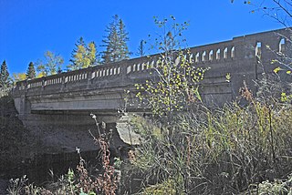
The M-28–Tahquamenon River Bridge is a bridge located on M-28 over the Tahquamenon River in Chippewa Township, Michigan. It was listed on the National Register of Historic Places (NRHP) in 1999.

The Stony Creek Bridge is a bridge located on a private road over Stony Creek in Olive Township, Clinton County, Michigan. It was listed on the National Register of Historic Places in 1999. It is the last example of a queen post truss bridge extant in Michigan.

The Waterman Covered Bridge was an historic covered bridge in Johnson, Vermont that carried Waterman Road across Waterman Creek. Built in 1868, it was one of three surviving 19th-century bridges in the town. It was listed on the National Register of Historic Places in 1974, and collapsed in January 1982.

The Burwell Bridge was a historic bridge on the northern edge of Burwell in Garfield County, Nebraska which was built in 1940-41. It was a steel girder bridge that brings Nebraska Highway 11 over the North Loup River. It is also known as the North Loup River Bridge and denoted as NEHBS Number GFOO-13. It was listed on the National Register of Historic Places in 1992, and was delisted in 2019.

The Crystal Springs Street–Dowagiac River Bridge is a road bridge that carries Crystal Springs Street over the Dowagiac River near Sumnerville, Michigan. It was installed in that location in 2017. Between 1938 and 2016, the bridge was located approximately 50 miles away, and carried M-86 over the Prairie River near Nottawa, Michigan, and was known then as the M-86–Prairie River Bridge. The bridge was listed on the National Register of Historic Places in 2000, and is the last remaining camelback pony truss bridge used on the state trunkline system in Michigan.

The US-12–Coldwater River Bridge was a road bridge carrying Old US-12 over the Coldwater River in Coldwater, Michigan. It was listed on the National Register of Historic Places in 1999.

The Powers Highway-Battle Creek Bridge is a bridge that formerly carryied Powers Highway over Battle Creek in Brookfield Township, Michigan. It was listed on the National Register of Historic Places in 2000. The bridge is a double-intersection Warren truss, a design noted for its extremely lightweight members and low cost. It is the only known example of its type in Michigan.

The Ash Street-Sycamore Creek Bridge is a historic bridge located on Ash Street (MI-36) over Sycamore Creek in Mason, Michigan. It was listed on the National Register of Historic Places in 1999. It is one of the oldest T-beam bridges in Michigan.

The State Street Bridge, also known as the Fort Road Bridge or the Bridgeport Bridge, is a bridge carrying State Street over the Cass River in Bridgeport, Michigan. It was listed on the National Register of Historic Places in 1995.

The Gugel Bridge, also known as the Beyer Road – Cass River Bridge, is a bridge carrying Beyer Road over the Cass River in Frankenmuth Township, Michigan. It was listed on the National Register of Historic Places in 2000. It is the only remaining example in Michigan of a bridge with both a pony truss span and a main through truss span.
The Perrine Road Bridge is a bridge carrying North Saginaw Road over Sturgeon Creek in Larkin Township, Michigan. It was listed on the National Register of Historic Places in 1999. The bridge was moved in 2001 from its location at the time of nomination to the present location, carrying Perrine Road over Sturgeon Creek.

The Ball Road-Little Salt Creek Bridge, also known as simply the Ball Road Bridge, was a bridge carrying Ball Road over Little Salt Creek in Jasper Township, Michigan. It was listed on the National Register of Historic Places in 1999. The bridge was later demolished.

The Denton Road-Sparks Foundation Park Pond Bridge is a road bridge carrying Denton Road over the Sparks Foundation Park pond in Jackson, Michigan. The original bridge, constructed c. 1931, was listed on the National Register of Historic Places in 2000. This bridge was demolished and replaced in 2007.


