K Line Northern Extension

Last updated

LAMetroLogo.svg  K Line Northern
Extension Project  LACMTA Circle K Line.svg  
K Line Northern Extension Project Study Area Map.jpg
Official Metro map of the study area of the K Line Northern Extension Project
Overview
StatusProposed
Locale Crenshaw
Hollywood
Service
Type Light rail
System Los Angeles Metro Rail
Operator(s)LAMetroLogo.svg  Metro (LACMTA)
History
Planned opening2047 (expected)
Technical
Track gauge 4 ft 8+12 in (1,435 mm) standard gauge
Electrification Overhead line,  750 V DC
Route map

Contents

BSicon extKBHFa exruby.svg
Hollywood Bowl (optional)
BSicon tCONTgq red.svg
BSicon tHSTq red.svg
BSicon extINT exruby.svg
BSicon tCONTfq red.svg
Hollywood/Highland
LACMTA Circle B Line.svg  
BSicon extBHF exruby.svg
La Brea/Santa Monica
BSicon extSHI2lr~L exruby.svg
BSicon extSHI2lr~R exruby.svg
BSicon extBHF exruby.svg
BSicon extSTR exruby.svg
Fairfax/Santa Monica
BSicon extSTRc2 exruby.svg
BSicon num1e.svg
BSicon extABZg3 exruby.svg
BSicon extSTR exruby.svg
BSicon extBHF+1 exruby.svg
BSicon extSTR+tc4 exruby.svg
BSicon extSTR exruby.svg
San Vicente/Santa Monica
BSicon extBHF2 exruby.svg
BSicon extSTR+tc3 exruby.svg
BSicon extSTR exruby.svg
Beverly Center
BSicon extSTRc1 exruby.svg
BSicon extABZg+4 exruby.svg
BSicon num3la.svg
BSicon extBHF exruby.svg
La Brea/Beverly
BSicon extBHF exruby.svg
BSicon extSTR exruby.svg
Fairfax/1st
BSicon extd-CONT2 purple.svg
BSicon extSTR exruby.svg
BSicon extSTRc3 purple.svg
BSicon extSTR exruby.svg
BSicon extSTRc1 purple.svg
BSicon extHST2+4 purple.svg
BSicon extINT exruby.svg
BSicon extSTR exruby.svg
BSicon extSTRc3 purple.svg
Wilshire/Fairfax
LACMTA Circle D Line.svg  
BSicon extSTR exruby.svg
BSicon extSTRc1 purple.svg
BSicon extHST2+4 purple.svg
BSicon extINT exruby.svg
BSicon extSTRc3 purple.svg
Wilshire/La Brea
LACMTA Circle D Line.svg  
BSicon extSHI2+lr~L exruby.svg
BSicon extSHI2+lr~R exruby.svg
BSicon extSTRc1 purple.svg
BSicon extdCONT4- purple.svg
BSicon extBHF exruby.svg
Pico/Rimpau
BSicon dRP4q.svg
BSicon extSKRZ-G4 exruby.svg
BSicon dRP4q.svg
BSicon extBHF exruby.svg
Crenshaw/Adams
BSicon CONTgq saffron.svg
BSicon INTq saffron.svg
BSicon tKSTRxa exruby.svg
BSicon CONTfq saffron.svg
Expo/Crenshaw
LACMTA Circle E Line.svg  
BSicon tCONTf exruby.svg
LACMTA Circle K Line.svg   K Line

Wheelchair symbol.svg All stations are accessible

The K Line Northern Extension Project, formerly known as the Crenshaw Northern Extension Project, is a project planning a Los Angeles Metro Rail light rail transit corridor extension connecting Expo/Crenshaw station to Hollywood/Highland station in Hollywood. The corridor is a fully underground, north-south route along mostly densely populated areas on the western side of the Los Angeles Basin; it would be operated as part of the K Line. The Los Angeles County Metropolitan Transportation Authority (Metro) is prioritizing the project along with pressure from the West Hollywood residents. [1] [2] Construction is slated to start in 2041 and begin service by 2047 unless means to accelerate the project are found. [3]

Overview

The Los Angeles County Metropolitan Transportation Authority (Metro) budgeted $2.33 billion from Measure M. The Crenshaw/LAX corridor Line was a corridor designated for public transit. It became a light rail line between the C Line and the E Line, with planned connections to LAX. After almost ten years of construction, the K Line, as it was named, opened in 2022. A northern extension could connect with regional job centers and tourist destinations, such as Cedars-Sinai Medical Center, Beverly Center, The Grove, Farmers Market shopping area, and LACMA. The West Hollywood areas are also in the projected routes, Melrose and the Sunset Strip within walking distance.

Original planning

The original plans for the Crenshaw Corridor project connected Wilshire Blvd to LAX. However, during the environmental review, Metro determined that if LRT were selected as the preferred mode, the cost for the entire route would exceed the project budget. In December 2009, the Metro Board decided on LRT as the preferred mode; as a result, the part of the corridor north of Exposition Boulevard was deferred until funds became available. This segment can be considered a "Phase Two" extension of the original line.

Any Phase Two extension would be expected to connect to the D Line, the first phase of which is currently under construction as part of the D Line Extension project.

Map of the combined K line and Northern Extension as envisioned in 2008 Crenshaw corridor jerjoz.jpg
Map of the combined K line and Northern Extension as envisioned in 2008

In May 2009, Metro released a report on the feasibility of an extension north to Wilshire Boulevard. [4] It first screened two routes—one to Wilshire/La Brea, and another to Wilshire/Crenshaw. Through this screening, staff concluded that Wilshire/La Brea station would be more cost-effective and compatible with land uses and plans along it. Specifically, the report cited the following advantages of the La Brea route over the Crenshaw route:

  • Greater residential and job density,
  • Supportive land uses for a high-capacity subway,
  • Stronger regional potential to link this corridor northward towards Hollywood in the future,
  • Strong community support in the Hancock Park area and
  • Fewer geotechnical soil impacts compared to the Hydrogen sulfide soil along Crenshaw Blvd north of Pico Boulevard.

In October 2010, the Metro Board voted to eliminate the Wilshire/Crenshaw station from the D Line Subway Extension project for similar reasons. [5]

The 3.5-mile Wilshire/La Brea route heads north on Crenshaw to Venice, west on Venice to San Vicente, continuing northwest on San Vicente to La Brea, and then north on La Brea to Wilshire. It has three possible stations: Crenshaw/Adams (optional), Pico/San Vicente, and Wilshire/La Brea.

The feasibility report also allowed for two possible branches/extensions along La Brea Ave, Fairfax Ave, La Cienega Blvd, or San Vicente Blvd heading north of Wilshire into West Hollywood and/or Hollywood.

In November 2010, Metro staff produced an initial review of the feasibility of studying a new transit corridor to connect the Crenshaw Corridor to West Hollywood and/or Hollywood. [6]

In May 2014, the West Hollywood City Council considered a proposal by Council members John Heilman and Jeffrey Prang to engage a lobbyist to promote the need for Metro rail services in West Hollywood. The Heilman/Prang proposal notes that "former Los Angeles Mayor Antonio Villaraigosa assured West Hollywood representatives that West Hollywood would be 'next in line.'" [7] In 2015, the West Hollywood City Council launched the West Hollywood Advocates for Metro Rail (WHAM) as part of a campaign to win grassroots support for a Metro rail extension into the city. [8]

In September 2016, in a letter to West Hollywood City Council member Lindsey Horvath, Metro CEO Phil Washington outlined several steps Metro is taking to make the Crenshaw/LAX northern extension "shovel ready" should county voters approve Measure M, a countywide ballot measure adding new transit projects and expediting others previously approved under Measure R. [9]

Connection to Phase One

The final design of "Phase One" (the original project line south of Exposition Blvd to LAX) would determine how the Phase Two project could or would connect to Phase One. The original locally preferred alternative (LPA) for the Crenshaw/LAX Line from the draft environmental impact study (Draft EIS/EIR) specified an at-grade station at the Phase One Expo/Crenshaw terminus, with the Leimert Park tunnel ending several blocks south of that, near 39th Street. If Phase One were built per the LPA, then Phase Two would require the building of a new tunnel with a connection near 39th Street. This would need the north end of the Leimert Park tunnel to be outfitted with knockout panels to allow for the possible future extension north. [10]

Metro also studied "Design Option 6" for Phase One, which would extend the Leimert Park tunnel north to the line's northern terminus at Exposition, with an underground station at Crenshaw/Exposition. This design option was selected so that Phase Two can connect to Phase One directly at the Crenshaw/Exposition station's tunnels. This design option increased the cost of the original Phase One project by $236 million. [11]

Proposed routes

In July 2018, Metro released its initial set of rail concepts and rail alternatives for the corridor, conducted by AECOM. [1]

Initial alternatives analysis

The July 2018 concepts released by Metro included five alternative plans for study. These included different alignments but the same mode, light rail, as Phase 1 of the Crenshaw-LAX Line was currently under construction as light rail. Of the original five, a "Vermont Route" option was dropped in October 2019 due to public comments. A hybrid San Vicente option was added at the same time. On August 17, 2020, Metro recommended three final alignments for environmental analysis and advanced conceptual engineering. [12] [13] The current three alternatives considered are all south to north routes:

DEIR Alternative [14] DescriptionNew trips
(daily)
Estimated cost
(billions)
1: San Vicente Hybrid Alternative [1] Continuing north underground from Expo/Crenshaw station and veers northwest underneath San Vicente Boulevard. Heads north underneath Fairfax Avenue for one mile. Turns west underneath Beverly Boulevard at the Grove Market for one mile and heads north underneath San Vicente Boulevard at Beverly Center Mall for another mile. Then east underneath Santa Monica Boulevard through West Hollywood to terminate at Hollywood/Highland station or a Hollywood Bowl station in Hollywood. This route was added in late 2019 due to public comments about wanting direct access to local work and tourist destinations.90,0005.5
2: Fairfax Alternative [1] Continuing north underground from Expo/Crenshaw station and veers northwest underneath San Vicente Boulevard. Heads north underneath Fairfax Avenue through Central Los Angeles to West Hollywood, where it turns east underneath Santa Monica Boulevard towards Hollywood/Highland or Hollywood Bowl station in Hollywood.88,7004.7
3: La Brea Alternative [1] Continuing north underground from Expo/Crenshaw station and veers northwest underneath San Vicente Boulevard. Heads underneath La Brea Avenue through Central Los Angeles to West Hollywood, where it turns east underneath Santa Monica Boulevard towards Hollywood/Highland or Hollywood Bowl station in Hollywood.87,2003.0

The following table shows all potential metro stations and the alternatives for which they apply:

Intersection of La Cienega Boulevard and Beverly Boulevard. Possible station in Alt. 1 BeverlyCenterCorner.jpg
Intersection of La Cienega Boulevard and Beverly Boulevard. Possible station in Alt. 1
La Cienega Blvd. at Santa Monica Blvd. possible station for Alt. 1 West Hollywood - La Cienega Blvd.JPG
La Cienega Blvd. at Santa Monica Blvd. possible station for Alt. 1
Station Options [1] (North to South)Alt 1: H-SVAlt 2: FFAlt 3: LBConnecting
rail services [15]
Hollywood Bowl Yes check.svgYes check.svgYes check.svgDirect access to Hollywood Bowl. Added due to public comments. [13]
Hollywood/Highland (new connecting station to be built)Yes check.svgYes check.svgYes check.svgLACMTA Circle B Line.svg  B Line Hollywood Boulevard Entertainment District, Dolby Theatre
La Brea/Santa MonicaYes check.svgYes check.svgYes check.svgWest Hollywood Gateway shopping, The Lot (OWN), Jim Henson Company Lot, Desilu Studios & Sunset Las Palmas Studios nearby.
Fairfax/Santa MonicaYes check.svgYes check.svg-West Hollywood
San Vicente/Santa MonicaYes check.svg--West Hollywood Rainbow District, Pacific Design Center, The Troubadour
San Vicente/La Cienega/BeverlyYes check.svg-- Cedars-Sinai Medical Center, Beverly Center, Melrose Avenue Shopping District
Fairfax/3rd St.Yes check.svgYes check.svg- The Grove at Farmers Market, Television City, Holocaust Museum LA
La Brea/Beverly --Yes check.svgHigh-density neighborhood
Wilshire/Fairfax (under construction)Yes check.svgYes check.svg-LACMTA Circle D Line.svg  D Line Los Angeles County Museum of Art, Museum Row, High-density neighborhood and retail
Wilshire/La Brea (under construction)--Yes check.svgLACMTA Circle D Line.svg  D Line High density neighborhood and retail, Hancock Park
San Vicente/FairfaxYes check.svgYes check.svg- Little Ethiopia, San Vicente Park
San Vicente/Venice/PicoYes check.svgYes check.svgYes check.svgRe-construct the former PE Pico/Rimpau "Vineyard Junction station; current Pico-Rimpau Bus Transfer Station at Mid-town Crossing Center
Crenshaw/AdamsYes check.svgYes check.svgYes check.svgMid-Density neighborhood
Expo/Crenshaw Yes check.svgYes check.svgYes check.svgLACMTA Circle E Line.svg  E Line Continues south to LAX, the C Line and South Bay beach cities
Distance: Miles (Kilometers)9.9 (15.9)8.1 (13.0)6.5 (10.5)

Advocacy

The city council approved a resolution in May 2018 to expedite its environmental study to speed up the approval process with Metro. Metro's 2018 budget included $500,000 to begin the draft environmental study for the extension project. Residents created the "West Hollywood Advocates for Metro Rail" to advocate a new light rail or rapid transit line along Santa Monica Boulevard. [16] Former President of the Los Angeles City Council Herb Wesson wrote an op-ed piece in the Los Angeles Times advocating acceleration of the project. [17] Local Los Angeles U.S. representative Adam Schiff also voiced his support for acceleration in a letter to then Metro CEO Philip Washington in March 2019. [18]

Related Research Articles

<span class="mw-page-title-main">Los Angeles County Metropolitan Transportation Authority</span> Public transport agency in Los Angeles County, California, United States

The Los Angeles County Metropolitan Transportation Authority (LACMTA), branded as Metro, is the county agency that plans, operates, and coordinates funding for most of the public transportation system in Los Angeles County, California, the most populated county in the United States, and the largest public transit agency in the county as well.

<span class="mw-page-title-main">Transportation in Los Angeles</span> Complex multimodal regional, national and international hub for passenger and freight traffic

Los Angeles has a complex multimodal transportation infrastructure, which serves as a regional, national and international hub for passenger and freight traffic. The system includes the United States' largest port complex; an extensive freight and passenger rail infrastructure, including light rail lines and rapid transit lines; numerous airports and bus lines; vehicle for hire companies; and an extensive freeway and road system. People in Los Angeles rely on cars as the dominant mode of transportation, but since 1990 the Los Angeles County Metropolitan Transportation Authority has built over one hundred miles (160 km) of light and heavy rail serving more and more parts of Los Angeles and the greater area of Los Angeles County. As a result, Los Angeles was the last major city in the United States to get a permanent rail system installed.

<span class="mw-page-title-main">Crenshaw Boulevard</span> Major street in Los Angeles

Crenshaw Boulevard is a north-south thoroughfare in Los Angeles, California, United States, that runs through Crenshaw and other neighborhoods along a 23-mile route in the west-central part of the city.

<span class="mw-page-title-main">Los Angeles Metro Rail</span> Urban rail transit system serving Los Angeles County, California

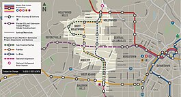
The Los Angeles Metro Rail is an urban rail transit system serving Los Angeles County, California in the United States. It consists of six lines: four light rail lines and two rapid transit lines, serving a total of 101 stations. It connects with the Metro Busway bus rapid transit system, the Metrolink commuter rail system, as well as several Amtrak lines. Metro Rail is owned and operated by the Los Angeles County Metropolitan Transportation Authority (Metro).

<span class="mw-page-title-main">Harbor Subdivision</span> Railway right-of-way in Los Angeles County, California

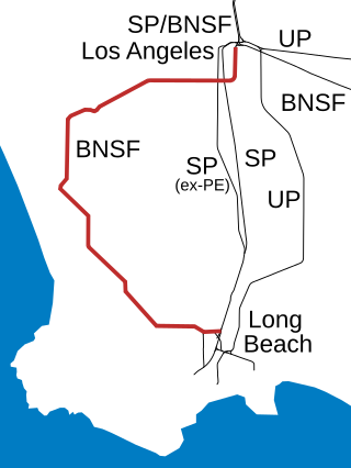
The Harbor Subdivision is a single-track main line of the BNSF Railway which stretches 53 miles (85 km) between rail yards near downtown Los Angeles and the ports of Los Angeles and Long Beach across southwestern Los Angeles County. It was the primary link between two of the world's busiest harbors and the national rail network. Mostly displaced with the April 15, 2002 opening of the more direct Alameda Corridor, the Harbor Sub takes a far more circuitous route from origin to destination, owing to its growth in segments over the decades. The subdivision was built in this fashion beginning in the early 1880s to serve the ports and the various businesses that developed along it.

<span class="mw-page-title-main">C Line (Los Angeles Metro)</span> Light rail line in Los Angeles County, California

The C Line is a 19.3-mile (31.1 km) light rail line running between Redondo Beach and Norwalk within Los Angeles County, California. It is one of six lines forming the Los Angeles Metro Rail system and opened on August 12, 1995. Along the route, the line serves the cities of Downey, El Segundo, Hawthorne, Norwalk and Lynwood, the Los Angeles community of Westchester, and several unincorporated communities in the South Los Angeles region including Athens, Del Aire, and Willowbrook. A free shuttle bus to Los Angeles International Airport (LAX) is available at the line's Aviation/LAX station.

<span class="mw-page-title-main">La Brea Avenue</span> Thoroughfare in Los Angeles, USA

La Brea Avenue is a prominent north-south thoroughfare in the City of Los Angeles and in Los Angeles County, California.

<span class="mw-page-title-main">D Line (Los Angeles Metro)</span> Rapid transit line in Los Angeles, California

The D Line is a fully underground 5.1-mile (8.2 km) rapid transit line operating in Los Angeles, running between Koreatown and Downtown Los Angeles. It is one of six lines on the Metro Rail system, operated by the Los Angeles County Metropolitan Transportation Authority.

<span class="mw-page-title-main">Regional Connector</span> Transit project in Los Angeles

The Regional Connector Transit Project constructed a 1.9-mile (3.1 km) light rail tunnel for the Los Angeles Metro Rail system in Downtown Los Angeles. It connected the A and E lines with the former L Line. The A and E lines previously both terminated at 7th Street/Metro Center station, coming from Long Beach and Santa Monica, respectively, while the L Line ran through Little Tokyo/Arts District to either Azusa or East Los Angeles. Now the A and E lines continue together through new stations at Grand Avenue Arts/Bunker Hill, Historic Broadway, and Little Tokyo/Arts District. From there, they diverge on the former L Line toward Azusa and East Los Angeles, respectively. The project provides a one-seat ride into the core of Downtown for passengers on those lines who previously needed to transfer, thus reducing or altogether eliminating many transfers of passengers traveling across the region via Downtown Los Angeles.

<span class="mw-page-title-main">K Line (Los Angeles Metro)</span> Light rail line in Los Angeles County, California

The K Line is a 5.9-mile (9.5 km) light rail line running north–south between the Jefferson Park and Westchester neighborhoods of Los Angeles, California, passing through various South Los Angeles neighborhoods and the city of Inglewood. It is one of six lines in the Los Angeles Metro Rail system operated by the Los Angeles County Metropolitan Transportation Authority (LACMTA). It opened on October 7, 2022, making it the system's newest line.

<span class="mw-page-title-main">Expo/Crenshaw station</span> Los Angeles Metro Rail station

Expo/Crenshaw station is a light rail station in the Los Angeles Metro Rail system located in the Jefferson Park neighborhood of Los Angeles at the intersection of Crenshaw and Exposition Boulevards. During construction, it was known as the Crenshaw station. The station is the transfer point between the E Line, which stops at two street-level platforms alongside Exposition Boulevard, and the K Line, which has its northern terminus at a single island platform under Crenshaw Boulevard.

<span class="mw-page-title-main">D Line Extension</span> Rapid transit construction project in Los Angeles, California

The D Line Subway Extension Project, formerly known as the Westside Subway Extension, the Subway to the Sea, and the Purple Line Extension, is a construction project in Los Angeles County, California, extending the rapid transit D Line of the Los Angeles Metro Rail system from its current terminus at Wilshire/Western in Koreatown, Los Angeles, to the Westside region. The project is being supervised by the Los Angeles County Metropolitan Transportation Authority (Metro). The subway has been given high priority by Metro in its long-range plans, and funding for the project was included in two county sales tax measures, Measure R and Measure M.

This article discusses the history of the Los Angeles County Metropolitan Transportation Authority, the regional transportation planning agency for Los Angeles County, California.

<span class="mw-page-title-main">Foothill Extension</span> Light rail extension project in Los Angeles County, California

The Foothill Extension Project, formerly known as the Gold Line Foothill Extension Project, is an extension of the Los Angeles Metro Rail A Line light rail line from the former Gold Line terminus in Pasadena, California, at Sierra Madre Villa station, east through the "Foothill Cities" of Los Angeles County. The plan's first stage, Phase 2A, extended the then-Gold Line from Pasadena to Azusa; it opened on March 5, 2016. Phase 2B, which will extend the now A Line a further four stations to Pomona–North station, broke ground in December 2017. A further two–station extension to Montclair Transcenter is planned for completion in 2028, but is currently unfunded.

<span class="mw-page-title-main">Sepulveda Transit Corridor</span> Proposed transit corridor in Los Angeles, California

The Sepulveda Transit Corridor Project is a two-phased planned transit corridor project that aims to connect the Los Angeles Basin to the San Fernando Valley through Sepulveda Pass in Los Angeles, California, by supplementing the existing I-405 freeway through the pass. The corridor would partly parallel I-405, and proposed alternatives include heavy rail rapid transit or a monorail line connecting the G Line in the Valley to the D Line and E Line on the Westside, and the K Line near Los Angeles International Airport.

<span class="mw-page-title-main">Wilshire/La Brea station</span> Under construction rapid transit station in Los Angeles County, California, USA

Wilshire/La Brea station is an under construction, underground rapid transit station on the D Line of the Los Angeles Metro Rail system at the intersection of Wilshire Boulevard and La Brea Avenue. It is slated to open in 2025. The D Line will serve it and will be the first station on that line west of Wilshire/Western station.

<span class="mw-page-title-main">Wilshire/Fairfax station</span> Under construction rapid transit station in Los Angeles County, California, USA

Wilshire/Fairfax station is an under construction, underground rapid transit station on the D Line of the Los Angeles Metro Rail system in LA's Miracle Mile area along Wilshire Boulevard at its intersection with Fairfax Avenue. It is slated to open in 2025. It will be served by the D Line and will be the second station west of Wilshire/Western station.

<span class="mw-page-title-main">LAX/Metro Transit Center station</span> Future light rail transport hub

LAX/Metro Transit Center station is an under construction light rail transport hub in the Los Angeles Metro Rail system, located near Aviation Boulevard and 96th Street in the Westchester district of Los Angeles. The station was designed as a station for the C and K lines. It will serve as the transfer point between Metro Rail and the LAX Automated People Mover (APM) serving the Los Angeles International Airport terminals and facilities. Additionally, the station will have connections to Metro Bus, other municipal bus lines, a customer service center, and a Metro Bike Share hub. Metro is scheduled to start serving the station in late 2024 before the APM connection opens on October 30, 2025.

The history of the Los Angeles Metro Rail and Busway system begins in the early 1970s, when the traffic-choked region began planning a rapid transit system. The first dedicated busway opened along I-10 in 1973, and the region's first light rail line, the Blue Line opened in 1990. Today the system includes over 160 miles (260 km) of heavy rail, light rail, and bus rapid transit lines, with multiple new lines under construction as of 2019.

References

  1. 1 2 3 4 5 6 "Feasibility study looks at possible routes for Crenshaw North Extension". Metro: The Source. July 22, 2018.
  2. "Rail concepts released for Sepulveda Transit Corridor project". Metro: The Source. June 8, 2018.
  3. "Five Options Under Consideration for the Crenshaw/LAX Line's Northern Extension". Urbanize Los Angeles. July 23, 2018.
  4. "Crenshaw Transit Corridor Project Final Feasibility Study - Wilshire/La Brea Transit Extension" (PDF). Metro (LACMTA). May 2009. Archived from the original (PDF) on June 29, 2011. Retrieved January 23, 2014.
  5. "AGENDA Regular Board of Directors Meeting" (PDF). Metro (LACMTA). October 28, 2010. pp. 10–12. Archived from the original (PDF) on June 29, 2011. Retrieved January 23, 2014.
  6. "Measure R Project Delivery Committee Hollywood/West Hollywood Transit Corridor Connection To Crenshaw/LAX Transit Corridor Initial Review" (PDF). Metro (LACMTA). November 18, 2010. Archived from the original (PDF) on June 29, 2011. Retrieved January 23, 2014.
  7. "WeHo to Consider Stepping Up Efforts to Lure a Metro Line Stop". WEHOville. May 2, 2014.
  8. "How West Hollywood Is Fighting for Its Own Subway". Los Angeles Magazine. February 23, 2016.
  9. "Metro Moves Up Date for Possible Northern Extension of Crenshaw/LAX Line". WEHOville. September 17, 2016.
  10. "Crenshaw-Prairie Transit Corridor Project Status Report" (PDF). Metro (LACMTA). March 19, 2008. Archived from the original (PDF) on December 6, 2008. Retrieved July 21, 2008.
  11. "Crenshaw/LAX Transit Corridor Project Final Environmental Impact Report/Final Environmental Impact Statement Executive Summary" (PDF). Metro (LACMTA). August 2011. p. ES-26. Retrieved January 21, 2014.
  12. Hymon, Steve (August 17, 2020). "Three routes recommended for further study on Crenshaw Northern Extension project". Metro: The Source.
  13. 1 2 Sharp, Steven (October 7, 2019). "West Hollywood Pushes to Accelerate Crenshaw Line Extension". Urbanize Los Angeles.
  14. Hymon, Steve (June 8, 2018). "Rail concepts released for Sepulveda Transit Corridor project". Metro: The Source.
  15. "Bus and Rail System Map" (PDF). Los Angeles County Metropolitan Transportation Authority. Retrieved December 3, 2018.
  16. "(home)". WHAM – West Hollywood Advocates for Metro Rail.
  17. Wesson, Herb (September 30, 2019). "Opinion: The Crenshaw Line is a start, but L.A.'s most transit-dependent neighborhoods need more options". Los Angeles Times.
  18. Scott, Henry E. (Hank) (March 20, 2019). "Adam Schiff Nudges Metro to Clarify Its Schedule for the Crenshaw Line Extension". WeHoVille.