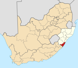
Kelso, South Africa

Last updated

Kelso
South Africa KwaZulu-Natal location map.svg
Red pog.svg
Kelso
South Africa adm location map.svg
Red pog.svg
Kelso
Coordinates: 30°21′37″S30°42′43″E / 30.36028°S 30.71194°E / -30.36028; 30.71194 Coordinates: 30°21′37″S30°42′43″E / 30.36028°S 30.71194°E / -30.36028; 30.71194
Country South Africa
Province KwaZulu-Natal
District Ugu
Municipality Umdoni
Area
[1]
  Total1.20 km2 (0.46 sq mi)
Population
 (2011) [1]
  Total425
  Density350/km2 (920/sq mi)
Racial makeup (2011)
[1]
   Black African 73.3%
   Coloured 0.5%
   Indian/Asian 11.1%
   White 14.9%
  Other0.2%
First languages (2011)
[1]
   Zulu 61.6%
   English 24.4%
   Xhosa 5.1%
   Afrikaans 4.4%
  Other4.4%
Time zone UTC+2 (SAST)
PO box
4183

Kelso is located in the uMdoni Coast region of South Africa facing the Indian Ocean. Kelso is located 65 kilometers south of Durban, the largest city in KwaZulu-Natal. [2]

Contents

History

Henry Cooke, one of the original mid-nineteenth century Byrne settlers, named the South African coastal village after the town of Kelso on the Tweed River in Scotland. Before modern transportation, the village of Kelso served as an important link in the transportation of sugar. Vessels launched on the Umzinto River could take their cargo out to the larger ships anchored at sea, off the river mouth.

The Umzinto River, which borders its southern side was the site of a mini gold rush during the 1860s. [3]

Recreation

Kelso is known for its excellent golden beaches and waves that provide great conditions for kitesurfing and surfing. Several competitions take place here annually, including hosting part of the South Coast Surf Carnival. [4]

Fishing at sea is also a popular activity.

Transport

Kelso is served by the railway from Port Shepstone to Durban and had a branch to Umzinto, connecting to the Umzinto - Donnybrook narrow gauge railway until its closure in 1987.

Major roads are the N2 and the R102.

Related Research Articles

<span class="mw-page-title-main">KwaZulu-Natal</span> Province in South Africa

KwaZulu-Natal is a province of South Africa that was created in 1994 when the Zulu bantustan of KwaZulu and Natal Province were merged. It is located in the southeast of the country, with a long shoreline on the Indian Ocean and sharing borders with three other provinces and the countries of Mozambique, Eswatini and Lesotho. Its capital is Pietermaritzburg, and its largest city is Durban. It is the second-most populous province in South Africa, with slightly fewer residents than Gauteng.

<span class="mw-page-title-main">Durban</span> Third largest city in South Africa

Durban, nicknamed Durbs, is the third most populous city in South Africa after Johannesburg and Cape Town and the largest city in KwaZulu-Natal. Durban forms part of the eThekwini Metropolitan Municipality, which includes neighbouring towns and has a population of about 3.44 million, making the combined municipality one of the largest cities on the Indian Ocean coast of the African continent. Durban was also one of the host cities of the 2010 FIFA World Cup.

<span class="mw-page-title-main">Estcourt</span> Place in KwaZulu-Natal, South Africa

Estcourt is a town in the uThukela District of KwaZulu-Natal Province, South Africa. The main economic activity is farming with large bacon and processed food factories situated around the town. The N3 freeway passes close to the town, linking it to the rest of South Africa.

<span class="mw-page-title-main">Margate, South Africa</span> Resort town in KwaZulu-Natal, South Africa

Margate is a coastal resort town in the Kwa-Zulu Natal province, about 20 kilometres southwest of Port Shepstone. The river which flows into the sea at Margate is called "Nkhongweni" (place of entreaty) because the original inhabitants were reputed to be so mean that travellers had to beg for hospitality.

<span class="mw-page-title-main">Port Shepstone</span> Seaside town in KwaZulu-Natal, South Africa

Port Shepstone is a large town situated on the mouth of the Mzimkhulu River, the largest river on the KwaZulu-Natal South Coast of South Africa. It is located halfway between Hibberdene and Margate and is positioned 120 km south of Durban. It is the administrative, educational and commercial centre for southern Natal.

<span class="mw-page-title-main">Scottburgh</span> Place in KwaZulu-Natal, South Africa

Scottburgh is a coastal resort town located on the south coast of KwaZulu-Natal, South Africa. It situated on the mouth of the Mpambanyoni River (confuser of birds). Neighbouring towns include Pennington, Renishaw, Freeland Park, Umkomaas, Sezela, Bazley, Amahlongwa, Amandawe Mission, Clansthal, Park Rynie and Dududu.

<span class="mw-page-title-main">Mooi River (town)</span> Place in KwaZulu-Natal, South Africa

Mooi River is a small town situated at 1,389 m above sea level and 160 km from the coast in KwaZulu-Natal, South Africa. The first European settlement in the area was at Mooi River Drift in 1852. This was formally named Weston in 1866 after the first Governor of Natal, Martin West.

Amanzimtoti Place in KwaZulu-Natal, South Africa

Amanzimtoti is a coastal town just south of Durban, KwaZulu-Natal, South Africa. The town is well known for its warm climate and numerous beaches, and is a popular tourist destination, particularly with surfers. The annual sardine run attracts many to the Toti beaches.

Doonside is a small coastal resort town on the KwaZulu-Natal South Coast some 30 km south-west of Durban in KwaZulu-Natal, South Africa, between Amanzimtoti and Illovo Beach. It is a part of the eThekwini metropolitan municipality.

Isipingo is a town situated 19 kilometres (12 mi) south of Durban in KwaZulu-Natal, South Africa and currently forms part of eThekwini Metropolitan Municipality. The town is named after the Siphingo River, which in turn is thought to be named for the intertwining cat-thorn shrubs (Scutia myrtina) present in the area, or the river's winding course.

Umzinto is a town, located in the South Coast of KwaZulu-Natal, South Africa and falls under the uMdoni Local Municipality. It was a sugarcane growing area and the town was set up as the centre for a sugar mill. The first public company in Natal was established at Umzinto on the 6th of July, 1846.

<span class="mw-page-title-main">Umzumbe</span> Seaside town in KwaZulu-Natal, South Africa

Umzumbe is a seaside resort situated at the mouth of the Mzumbe River (bad kraal) in KwaZulu-Natal, South Africa. The name of the river is derived from a band of Hlongwa cannibals who occupied the valley. The Hlongwa was almost wiped out by the Zulu king Shaka in 1828.

<span class="mw-page-title-main">Ugu District Municipality</span> District municipality in KwaZulu-Natal, South Africa

Ugu is one of the 11 districts of KwaZulu-Natal province of South Africa. Ugu is Zulu for "coast". It governs the KZN South Coast and its seat is Port Shepstone. The majority of its 722,484 people speak IsiZulu. The district code is DC21.

<span class="mw-page-title-main">Natal Government Railways</span>

The Natal Government Railways (NGR) was formed in January 1877 in the Colony of Natal.

Natal Railway 0-4-0WT <i>Natal</i>

The Natal Railway 0-4-0WTNatal of 1860 was a South African steam locomotive from the pre-Union era in the Natal Colony.

South African Class NG3 4-6-2T

The South African Railways Class NG3 4-6-2T of 1907 was a narrow-gauge steam locomotive from the pre-Union era in the Colony of Natal.

Umbogintwini is a suburb located approximately 23 km south-west of Durban, in KwaZulu-Natal, South Africa.

<span class="mw-page-title-main">Mthwalume</span> Place in KwaZulu-Natal, South Africa

Mtwalume is a settlement in Ugu District Municipality in the KwaZulu-Natal province of South Africa.

<span class="mw-page-title-main">KwaZulu-Natal South Coast</span> Coastal region in KwaZulu-Natal, South Africa

KwaZulu-Natal South Coast is a region on the southern coast of KwaZulu-Natal, South Africa. It stretches from Scottburgh in the north to Port Edward in the south and Harding in the west. The coast is governed by the Ugu District Municipality.

Craigieburn is a township west of Umkomaas in KwaZulu-Natal, South Africa. It was created by the apartheid government in the apartheid era to segregate the Indian population.

References

  1. 1 2 3 4 "Sub Place Kelso". Census 2011.
  2. "Kitesurfing Holidays in Kwazulu-Natal, South Africa". Zoco Travel. Archived from the original on 18 July 2011. Retrieved 27 February 2010.
  3. "Scottsburg South Coast KZN South Africa History" . Retrieved 27 February 2010.
  4. "South Coast Surf Carnival". Surfer's Village. Retrieved 27 February 2010.