
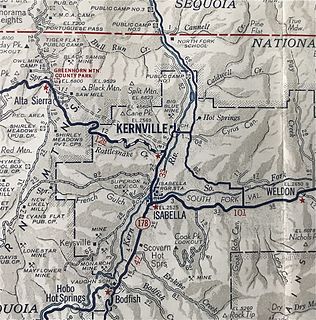
Kernville is a census-designated place (CDP) in the southern Sierra Nevada, in Kern County, California, United States. Kernville is located 42 miles (68 km) northeast of Bakersfield, at an elevation of 2,667 feet (813 m). The population was 1,395 at the 2010 census, down from 1,736 at the 2000 census.

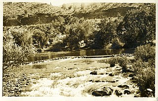
The Kern River, originally Rio de San Felipe, later La Porciuncula, is a river in the U.S. state of California, approximately 165 miles (270 km) long. It drains an area of the southern Sierra Nevada mountains northeast of Bakersfield. Fed by snowmelt near Mount Whitney, the river passes through scenic canyons in the mountains and is a popular destination for whitewater rafting and kayaking. It is the southernmost major river system in the Sierra Nevada, and is the only major river in the Sierra that drains in a southerly direction.

Keyesville is an unincorporated community in Kern County, California. It is located 2 miles (3.2 km) west of Lake Isabella and the Kern River Valley, at an elevation of 2,848 feet (868 m). Keyesville, founded in 1854 is named for Richard M. Keyes, whose discovery of gold in 1853 started the Kern River Gold Rush.

Willow Springs is an unincorporated community in Kern County, California, United States. It is located 7.5 miles (12 km) west of Rosamond, at an elevation of 2,523 feet (769 m).

The South Fork Kern River is a tributary of the Kern River in the Sierra Nevada of the U.S. state of California. It is one of the southernmost rivers on the western slope of the mountains, and drains a high, relatively dry plateau country of 982 square miles (2,540 km2) along the Sierra Crest. The upper South Fork flows through a series of rugged canyons, but it also drains a flat, marshy valley before joining the Kern River at Lake Isabella.
South Lake is an unincorporated community in the Kern River Valley, in Kern County, California. It is located 4.5 miles (7.2 km) west-southwest of Weldon, at an elevation of 2,887 feet (880 m).
Kernville is a former settlement in the Kern River Valley of the Sierra Nevada, in Kern County, California.

Alameda is an unincorporated community in Kern County, California. It is located 9 miles (14 km) south of Bakersfield, at an elevation of 331 feet (101 m).
China Lake is an unincorporated community in Kern County, California. It is located 2.5 miles (4 km) north-northeast of Ridgecrest, at an elevation of 2264 feet. The place is on China Lake, a dry lake on the Naval Air Weapons Station China Lake.
Desert Lake is an unincorporated community in Kern County, California.
Gypsite is an unincorporated community in Kern County, California.
Isabella is a former settlement in Kern County, California. It was located 4.5 miles (7.2 km) north-northeast of Bodfish, at an elevation of 2516 feet. The site was inundated by Lake Isabella.
Meridian is an unincorporated community in Kern County, California. It is located 4.5 miles (7.2 km) northeast of Mettler, at an elevation of 433 feet (132 m).
Muroc is a former settlement in Kern County, California in the Mojave Desert.

Old River is an unincorporated community in Kern County, California. It is located 9.5 miles (15 km) southwest of Bakersfield, at an elevation of 344 feet (105 m).
Panama, formerly named Rio Bravo after the Spanish name for the Kern River, Rio Bravo de San Felipe, is an unincorporated community in Kern County, California. It is located 8 miles (13 km) south-southwest of Bakersfield, at an elevation of 351 feet (107 m) in the San Joaquin Valley.
Saltdale is an unincorporated community in Kern County, California. It is located near Koehn Lake 21 miles (34 km) south-southwest of Ridgecrest near Garlock, California.
Miracle Hot Springs is an unincorporated community in the Kern River Valley, in Kern County, California. It is located along the Kern River in the Sequoia National Forest 10 miles (16 km)West of Lake Isabella, California, at an elevation of 2,382 feet (726 m).
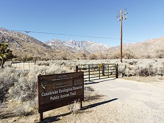
Canebrake Ecological Reserve is a 6,700-acre (27 km2) nature reserve in the South Fork Valley of Kern County, 20 miles (32 km) east of Lake Isabella, California. It is located in the Southern Sierra Nevada region.

Buena Vista Lake was a fresh-water lake in Kern County, California, in the Tulare Lake Basin in the southern San Joaquin Valley, California.


