Kern County is located in the U.S. state of California. As of the 2010 census, the population was 839,631. Its county seat is Bakersfield.

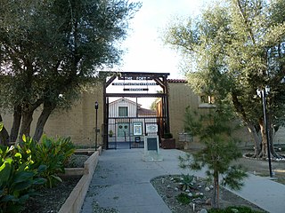
Taft is a city in the foothills at the extreme southwestern edge of the San Joaquin Valley, in Kern County, California. Taft is located 32 miles (51 km) west-southwest of Bakersfield, at an elevation of 955 feet (291 m). The population was 9,327 at the 2010 census. According to the United States Census Bureau, the city has a total area of 15.1 square miles (39.1 km2).

The Bonneville Power Administration (BPA) is an American federal agency operating in the Pacific Northwest. BPA was created by an act of Congress in 1937 to market electric power from the Bonneville Dam located on the Columbia River and to construct facilities necessary to transmit that power. Congress has since designated Bonneville to be the marketing agent for power from all of the federally owned hydroelectric projects in the Pacific Northwest. Bonneville is one of four regional Federal power marketing agencies within the U.S. Department of Energy (DOE).

Beowawe is a small town, misnomered on the internet as a ghost town, in Eureka County, Nevada, United States.

Caliente is an unincorporated community in Kern County, California. It is located 22 miles (35 km) east-southeast of Bakersfield, at an elevation of 1,312 feet (400 m).

The Moss Landing Power Plant is a natural gas powered electricity generation plant located in Moss Landing, California, United States, at the midpoint of Monterey Bay. Its large stacks are landmarks, visible throughout the Monterey Bay Area. The plant is owned and operated by Houston-based Dynegy and currently has a generation capacity of 1020 MW (net) from its two combined cycle generation units. It was once the largest power plant in the state of California, with a generation capacity of 2560 MW, before its two large supercritical steam units were taken offline.

Path 15 is an 84-mile (135 km) portion of the north-south power transmission corridor in California, U.S. It forms a part of the Pacific AC Intertie and the California-Oregon Transmission Project. Path 15 is part of The Western Electricity Coordinating Council's links of electrical intertie paths in the western United States.

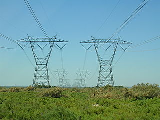
Path 26 is a set of three Southern California Edison (SCE) 500 kV power lines, located primarily in Los Angeles County, and extending into Kern and Ventura counties, all in California. Path 26 is part of the Western Electricity Coordinating Council's links of electrical intertie paths in the western United States. The Path 26 lines are located in: the San Joaquin Valley of the southern Central Valley; the Tehachapi Mountains and other central Transverse Ranges; and the Antelope Valley section of the Mojave Desert.

East Bakersfield is a region in Bakersfield, California directly east of downtown. The region was formerly known as the town of Sumner, which was later incorporated and renamed Kern City. It is primarily a mixture of residential and commercial developments. It also contains a small business district centered on the intersection of Baker and Sumner streets. Census data is provided on the right for the time period when the region was an independent town and city. It is part of the Bakersfield urban area of almost 500,000 people.

Bealville is an unincorporated community in Kern County, California. It is located on the Union Pacific Railroad 1.25 miles (2 km) south of Caliente, at an elevation of 1,811 feet (552 m). The area was named after Edward Fitzgerald Beale, who owned the adjacent Rancho El Tejon.

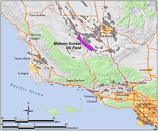
The Midway-Sunset Oil Field is a large oil field in Kern County, San Joaquin Valley, California in the United States. It is the largest known oilfield in California and the third largest in the United States.

Edison is an unincorporated community in Kern County, California. It is located 7.5 miles (12 km) east-southeast of downtown Bakersfield, at an elevation of 568 feet (173 m).

Bena is an unincorporated community in Kern County, California. It is located on the Union Pacific Railroad 7 miles (11 km) west-northwest of Caliente, at an elevation of 863 feet (263 m).

Cameron was an unincorporated community in the Tehachapi Mountains, in Kern County, California. It is located on the Union Pacific Railroad 9 miles (14 km) east-southeast of Tehachapi,

Jasmin is an unincorporated community in Kern County, California. It is located on the Southern Pacific Railroad 6.5 miles (10 km) northeast of McFarland, at an elevation of 453 feet (138 m).

Monolith is an unincorporated community in the Tehachapi Valley, in Kern County, California.

Saco is an unincorporated community in Kern County, California. It is located on the Southern Pacific Railroad 7 miles (11 km) northwest of Bakersfield, at an elevation of 453 feet (138 m).

Wible Orchard is a place now part of Bakersfield, Kern County, California. It is located on the Southern Pacific Railroad 4.25 miles (6.8 km) south-southwest of downtown Bakersfield, at an elevation of 377 feet (115 m).
The California oil and gas industry has been a major industry for over a century. Oil production was a minor factor in the 19th century, with kerosene replacing whale oil and lubricants becoming essential to the machine age. Oil became a major California industry in the 20th century with the discovery on new fields around Los Angeles and the San Joaquin Valley, and the dramatic increase in demand for gasoline to fuel automobiles and trucks. In 1900 California pumped 4 million barrels (640,000 m3), nearly 5% of the national supply. Then came a series of major discoveries, and the state pumped 100 million bbl (16 million m3) in 1914, or 38% of the national supply. In 2012 California produced 197 million bbl (31 million m3) of crude oil, out of the total 2,375 million bbl (378 million m3) of oil produced in the U.S, representing 8.3% of national production. California drilling operations and oil production are concentrated primarily in Kern County, San Joaquin Valley and the Los Angeles basin.

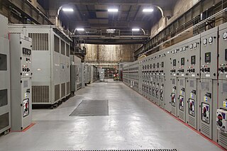
M42 is a sub-basement of Grand Central Terminal in Midtown Manhattan, New York City. The basement contains an electrical substation that provides electricity to the terminal and helps power its tracks' third rails.


