Related Research Articles

Mojave is an unincorporated community in Kern County, California, United States. Mojave is located 50 miles (80 km) east of Bakersfield, and 100 miles (161 km) north of Los Angeles, at an elevation of 2,762 feet (842 m). The town is located in the southwestern region of the Mojave Desert, below and east of Oak Creek Pass and the Tehachapi Mountains.

The Mojave Desert is an arid rain-shadow desert and the driest desert in North America. It is in the Southwestern United States, primarily within southeastern California and southern Nevada, and it occupies 47,877 sq mi (124,000 km2). Small areas also extend into Utah and Arizona. Its boundaries are generally noted by the presence of Joshua trees, which are native only to the Mojave Desert and are considered an indicator species, and it is believed to support an additional 1,750 to 2,000 species of plants. The central part of the desert is sparsely populated, while its peripheries support large communities such as Las Vegas in Nevada, Barstow, Lancaster, Palmdale, and Victorville in California, and St. George in Utah.

Mojave National Preserve is a United States National Preserve located in the Mojave Desert of San Bernardino County, California, USA, between Interstate 15 and Interstate 40. The preserve was established October 31, 1994, with the passage of the California Desert Protection Act by the US Congress. Previously, it was the East Mojave National Scenic Area, under the jurisdiction of the Bureau of Land Management. At 1,542,776 acres (6,243 km2), it is the third largest unit of the National Park System in the contiguous United States.

The Mojave River is an intermittent river in the eastern San Bernardino Mountains and the Mojave Desert in San Bernardino County, California, United States. Most of its flow is underground, while its surface channels remain dry most of the time, with the exception of the headwaters and several bedrock gorges in the lower reaches.

The Goldstone Deep Space Communications Complex (GDSCC), commonly called the Goldstone Observatory, is a satellite ground station located in the Mojave Desert near Barstow in the U.S. state of California. Operated by NASA's Jet Propulsion Laboratory (JPL), its main purpose is to track and communicate with interplanetary space missions. It is named after Goldstone, California, a nearby gold-mining ghost town.
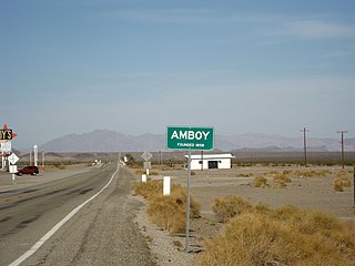
Amboy is an unincorporated community in San Bernardino County, in California's Mojave Desert, west of Needles and east of Ludlow on historic Route 66. It is roughly 60 miles (97 km) northeast of Twentynine Palms. Prior to 2015, the town's business district contained a post office, a historic restaurant-motel, and a Route 66 tourist shop.
Nipton is an unincorporated community in the Ivanpah Valley in San Bernardino County, California. With a population of about 15 – 20, it is located on the northeastern border of Mojave National Preserve, approximately 12 miles southeast of Primm, Nevada and the Ivanpah Solar Power Facility. It is accessible via Nevada State Route 164.

The Victor Valley is a valley in the Mojave Desert and subregion of the Inland Empire, in San Bernardino County in Southern California.

Old Las Vegas Mormon Fort State Historic Park is a state park of Nevada, USA, containing the Old Mormon Fort, the first structure built by people of European heritage in what would become Las Vegas fifty years later. In present-day Las Vegas, the site is at the southeast corner of Las Vegas Boulevard and Washington Avenue, less than one mile north of the downtown area and Fremont Street. This is the only U.S. state park located in a city that houses the first building ever built in that city. The fort was listed on the National Register of Historic Places on February 1, 1972. The site is memorialized with a tablet erected by The Church of Jesus Christ of Latter-day Saints in 1997, along with Nevada Historical Marker #35, and two markers placed by the Daughters of Utah Pioneers.

The Old Spanish Trail is a historical trade route that connected the northern New Mexico settlements of Santa Fe, New Mexico with those of Los Angeles, California and southern California. Approximately 700 mi (1,100 km) long, the trail ran through areas of high mountains, arid deserts, and deep canyons. It is considered one of the most arduous of all trade routes ever established in the United States. Explored, in part, by Spanish explorers as early as the late 16th century, the trail saw extensive use by pack trains from about 1830 until the mid-1850s.

Cantil is an unincorporated community in Kern County, California. It is in the Fremont Valley of the western Mojave Desert.

Newberry Springs is an unincorporated community in the western Mojave Desert of Southern California, located at the foot of the Newberry Mountains in San Bernardino County, California, United States. The population at the 2000 census was 2,895.

Helendale or Silver Lakes is an unincorporated community and census-designated place located in the Victor Valley of the Mojave Desert, within San Bernardino County, California.

Barstow Harvey House, also known as Harvey House Railroad Depot and Barstow station, is a historic building in Barstow, California. Originally built in 1911 as Casa del Desierto, a Harvey House hotel and Santa Fe Railroad depot, it currently serves as an Amtrak station and government building housing city offices, the Barstow Chamber of Commerce and Visitor Center, and two museums.
Sage is a former settlement in Kern County, California.
Warren is a former settlement in Kern County, California.
Desert Spring is a former settlement in Kern County, California in the Fremont Valley, south of Red Rock Canyon State Park. It was located 1.5 miles (2.4 km) northeast of Cantil. About .8 miles norht of California State Route 58 on Bellville Road at the railroad tracks.
Hodge is an unincorporated community in the Mojave Desert, within San Bernardino County, California, United States.
Bryman, is a populated place in the central Mojave Desert, within San Bernardino County, California. It lies along the Mojave River in the northern Victor Valley, at an elevation of 2,526 feet . It is on the historic U.S. Route 66, 5 miles north of Oro Grande, and south of Helendale.
References
- 1 2 3 Durham, David L. (1998). California's Geographic Names: A Gazetteer of Historic and Modern Names of the State. Clovis, Calif.: Word Dancer Press. p. 1074. ISBN 1-884995-14-4.

| | This Kern County, California-related article is a stub. You can help Wikipedia by expanding it. |