Semitropic, California

Last updated
Semitropic
Unincorporated community
California Locator Map with US.PNG
Red pog.svg
Semitropic
Location in California
Usa edcp location map.svg
Red pog.svg
Semitropic
Semitropic (the US)
Coordinates: 35°36′07″N119°30′30″W / 35.60194°N 119.50833°W / 35.60194; -119.50833 Coordinates: 35°36′07″N119°30′30″W / 35.60194°N 119.50833°W / 35.60194; -119.50833
Country United States
State California
County Kern County
Elevation [1] 256 ft (78 m)

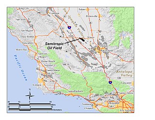
Semitropic (formerly, Semi Tropic) [2] is an unincorporated community in Kern County, California. [1] It is located 10.5 miles (17 km) east of Lost Hills, [2] at an elevation of 256 feet (78 m). [1] The settlement gives its name to the surrounding Semitropic Oil Field, currently operated by Vintage Production LLC.

Unincorporated area Region of land not governed by own local government

In law, an unincorporated area is a region of land that is not governed by a local municipal corporation; similarly an unincorporated community is a settlement that is not governed by its own local municipal corporation, but rather is administered as part of larger administrative divisions, such as a township, parish, borough, county, city, canton, state, province or country. Occasionally, municipalities dissolve or disincorporate, which may happen if they become fiscally insolvent, and services become the responsibility of a higher administration. Widespread unincorporated communities and areas are a distinguishing feature of the United States and Canada. In most other countries of the world, there are either no unincorporated areas at all, or these are very rare; typically remote, outlying, sparsely populated or uninhabited areas.

Kern County, California County in California, United States

Kern County is a county in the U.S. state of California. As of the 2010 census, the population was 839,631. Its county seat is Bakersfield.

California State of the United States of America

California is a state in the Pacific Region of the United States. With 39.6 million residents, California is the most populous U.S. state and the third-largest by area. The state capital is Sacramento. The Greater Los Angeles Area and the San Francisco Bay Area are the nation's second and fifth most populous urban regions, with 18.7 million and 8.8 million residents respectively. Los Angeles is California's most populous city, and the country's second most populous, after New York. California also has the nation's most populous county, Los Angeles County, and its largest county by area, San Bernardino County. The City and County of San Francisco is both the country's second-most densely populated major city after New York and the fifth-most densely populated county, behind only four of the five New York City boroughs.

A post office operated at Semitropic from 1893 to 1913, moving in 1904 and in 1905. [2] The name honored the Semitropic Fruit Company. [2]

Related Research Articles

Mayaro, California Unincorporated community in California, United States

Mayaro is an unincorporated community in Butte County, California. It lies at an elevation of 1522 feet and is located at 39°49′27″N121°25′20″W. A post office operated at Mayaro from 1930 to 1956.

Merrimac, California Unincorporated community in California, United States

Merrimac is an unincorporated community in Butte County, California located along Oroville-Quincy Road about 2.1 miles (3.4 km) south of the Plumas County line. It lies at an elevation of 3999 feet. While the location is shown as official in the National Geographic Names Database, it is not known if locals use this name to describe the place today. Nearby is Rogers Cow Camp, a campground in Lassen National Forest. The USGS feature ID for this populated place is 1659117. The US Postal Service does not show a ZIP Code for this community. The location is within area code 530.

Dodgeland, California Unincorporated community in California, United States

Dodgeland is an unincorporated community in Butte County, California. It lies at an elevation of 105 feet and is located 39°32′41″N121°54′28″W. A post office operated at Dodgeland from 1918 to 1923.

Lumpkin, California Unincorporated community in California, United States

Lumpkin is an unincorporated community in Butte County, California. It lies at an elevation of 3586 feet. It is located 6 miles (10 km) north-northwest of Clipper Mills on the Feather River Railway. A post office operated at Lumpkin from 1886 to 1919.

Powellton, California Unincorporated community in California, United States

Powellton is an unincorporated community in Butte County, California, USA. It lies at an elevation of 3,622 feet. The place is named for R.P. Powell who arrived in 1853. A post office operated in Powellton from 1872 to 1906.

Wicks Corner, California Unincorporated community in California, United States

Wicks Corner is an unincorporated community in Butte County, California, at the junction of California State Route 70 and California State Route 149. It lies at an elevation of 272 feet.

Annette, California Unincorporated community in California, United States

Annette is an unincorporated community in Kern County, California. It is located 6.5 miles (10 km) south-southwest of Orchard Peak, at an elevation of 2,198 feet (670 m).

Cameron, Kern County, California Unincorporated community in California, United States

Cameron is an unincorporated community in the Tehachapi Mountains, in Kern County, California. It is located on the Union Pacific Railroad 9 miles (14 km) east-southeast of Tehachapi, at an elevation of 3,802 feet (1,159 m).

Gypsite, California Unincorporated community in California, United States

Gypsite is an unincorporated community in Kern County, California.

Jasmin, California Unincorporated community in California, United States

Jasmin is an unincorporated community in Kern County, California. It is located on the Southern Pacific Railroad 6.5 miles (10 km) northeast of McFarland, at an elevation of 453 feet (138 m).

Leliter, California Former settlement in California, United States

Leliter is a former settlement in Kern County, California. It was located on the Southern Pacific Railroad 4.5 miles (7.2 km) north-northwest of Inyokern, at an elevation of 2303 feet. Leliter still appeared on maps as of 1943.

Minter Village, California Unincorporated community in California, United States

Minter Village is an unincorporated community in Kern County, California. It is located 13 miles (21 km) northwest of Bakersfield, at an elevation of 423 feet.

Piute, California Former settlement in California, United States

Piute is a former settlement in Kern County, California. It was located 5.25 miles (8.4 km) north-northeast of Loraine, at an elevation of 5016 feet.

Rio Bravo, California Unincorporated community in California, United States

Rio Bravo is an unincorporated community in Kern County, California. It is located on the Southern Pacific Railroad 7.25 miles (12 km) south of Shafter, at an elevation of 318 feet (97 m).

Rowen, California Unincorporated community in California, United States

Rowen is located on the railroad 1.5 miles (2.4 km) northwest of Keene, at an elevation of 2,395 feet (730 m).

Saco, California Unincorporated community in California, United States

Saco is an unincorporated community in Kern County, California. It is located on the Southern Pacific Railroad 7 miles (11 km) northwest of Bakersfield, at an elevation of 453 feet (138 m).

Saltdale, California Unincorporated community in California, United States

Saltdale is an unincorporated community in Kern County, California. It is located near Koehn Lake 21 miles (34 km) south-southwest of Ridgecrest near Garlock, California.

Miramonte is a former settlement in Kern County, California. It was located 5 miles (8 km) north of Semitropic.

Glenblair, California Unincorporated community in California, United States

Glenblair is an unincorporated community in Mendocino County, California. It is located 15 miles (24 km) north-northwest of Comptche, at an elevation of 207 feet.

Semitropic Oil Field

The Semitropic Oil Field is an oil and gas field in northwestern Kern County in California in the United States, within the San Joaquin Valley. Formerly known as the Semitropic Gas Field, it was discovered by the Standard Oil Company of California in 1935, and first understood to be primarily a natural gas reservoir; however, in 1956 a much deeper oil-bearing zone was discovered. The field contains the deepest oil well ever drilled in California, at 18,876 feet (5,753 m). At the end of 2008 the field still had 56 active oil wells, most of which were owned by Occidental Petroleum, and the field had an estimated 343,000 barrels of oil still recoverable with current technology.

References

  1. 1 2 3 U.S. Geological Survey Geographic Names Information System: Semitropic, California
  2. 1 2 3 4 Durham, David L. (1998). California's Geographic Names: A Gazetteer of Historic and Modern Names of the State. Clovis, Calif.: Word Dancer Press. p. 1104. ISBN   1-884995-14-4.