Related Research Articles

Keene is a census-designated place (CDP) in Kern County, California in the foothills of the Tehachapi Mountains at the southern extreme of the San Joaquin Valley. Keene is located 8.5 miles (14 km) northwest of Tehachapi, at an elevation of 2,602 feet (793 m). The population was 431 at the 2010 census, up from 339 at the 2000 census.

Lake Isabella is a census-designated place (CDP) in the southern Sierra Nevada, in Kern County, California, United States. It is named after the Lake Isabella reservoir and located at its southwestern edge, 6 miles (9.7 km) south of Wofford Heights in the Kern River Valley.

Mettler, or Mettler Station, is a heavily Hispanic, low-income unincorporated area and census-designated place in Kern County, California. The population was 136 at the 2010 census, down from 157 at the 2000 census. It is the place where motion picture actor James Dean received a traffic ticket on the last day of his life.
Weedpatch is an unincorporated community and census-designated place (CDP) in Kern County, California, United States. Weedpatch is 10 miles (16 km) south-southeast of Bakersfield. It is considered to be one of the poorest areas in Kern County. As of the 2010 census it had a population of 2,658.

Weldon is a census-designated place (CDP) in Kern County, California, United States. It sits at the southeast tip of Lake Isabella. Weldon is located 9 miles (14 km) east-southeast of Wofford Heights, at an elevation of 2,654 feet (809 m). The population was 2,642 at the 2010 census, up from 2,387 at the 2000 census.
Borrego Springs is a census-designated place (CDP) in San Diego County, California. The population was 3,429 at the 2010 census, up from 2,535 at the 2000 census, made up of both seasonal and year-round residents. Borrego Springs is completely surrounded by Anza-Borrego State Park, the largest California State Park.
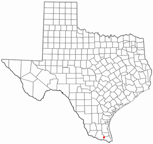
Santa Rosa is a town in Cameron County, Texas, United States. The population was 2,873 at the 2010 census. It is part of the Brownsville–Harlingen–Raymondville and the Matamoros–Brownsville metropolitan areas.

Stevenstown is a small unincorporated community in La Crosse County, Wisconsin, United States, in the town of Farmington. It is part of the La Crosse, Wisconsin Metropolitan Statistical Area.

Havilah is an unincorporated community in Kern County, California. It is located in the mountains between Walker Basin and the Kern River Valley, 5 miles (8.0 km) south-southwest of Bodfish at an elevation of 3,136 feet (956 m).

Santa Susana Pass State Historic Park is a California State Park of approximately 680 acres (2.8 km2) located on the boundary between Ventura and Los Angeles counties, between the communities of Chatsworth and Simi Valley. Geologically, the park is located where the Simi Hills meet the Santa Susana Mountains. Here in the western part of the Transverse Ranges, the land is dominated by high, narrow ridges and deep canyons covered with an abundant variety of plant life. The park offers panoramic views of the rugged natural landscape as a striking contrast to the developed communities nearby. The park is also rich in archaeological, historical, and cultural significance.
Emit is an unincorporated community in Johnston County, North Carolina, at the intersection of North Carolina Highway 39 and North Carolina Highway 231. It lies at an elevation of 285 feet.

Ingle is an unincorporated community in Fresno County, California. It is located on the Southern Pacific Railroad 7.25 miles (11.7 km) east-southeast of Mendota, at an elevation of 164 feet.
Nadeau is a former settlement in the Tehachapi Mountains, in Kern County, California.
Kern River Slough is a former settlement in Kern County, California.
State Line is a former settlement in Mono County, California. It was located on the Nevada state line 6 miles (10 km) north-northeast of Benton.
Golfland Entertainment Centers are a chain of family amusement centers, miniature golf courses, and water parks located in California and Arizona. The company was founded in 1953.
Mountain House or Willow Springs Station, in what is now Kern County, California, was a stage station of the Butterfield Overland Mail, located 12 miles south of Fountain Spring Station, and 15 miles northeast of Posey Creek Station at Willow Springs on Willow Springs Creek.
McKnight is an unincorporated community in Allegheny County, Pennsylvania, United States. The area known as McKnight is located in the municipality of Ross Township, in suburban Pittsburgh, and in the North Hills School District.
The North Fork Salmon River is a 36.9-mile (59.4 km) river in Siskiyou County, California. It joins with the South Fork Salmon River at Forks of Salmon to form the Salmon River, a major tributary of the Klamath River. Originating at English Lakes near 7,322-foot (2,232 m) English Peak in the Salmon Mountains, the North Fork drains about 204 square miles (530 km2) of rugged, forested terrain. The entire river is located within the Klamath National Forest, with the headwaters located in the Marble Mountain Wilderness.
The South Fork Salmon River is a 39.5-mile (63.6 km) river in Siskiyou County, California and is the larger of two tributaries that join to form the Salmon River, the other being the North Fork. It begins in the Salmon Mountains, on the border of Siskiyou and Trinity County, about 15 miles (24 km) southeast of Cecilville, and flows generally northwest through the Salmon Mountains to its confluence with the North Fork at Forks of Salmon. The South Fork drains an area of 290 square miles (750 km2), located entirely in the Klamath National Forest, with a significant portion in the Trinity Alps Wilderness.
References
- 1 2 3 Durham, David L. (1998). California's Geographic Names: A Gazetteer of Historic and Modern Names of the State. Clovis, Calif.: Word Dancer Press. p. 1017. ISBN 1-884995-14-4.

Coordinates: 35°15′24″N118°2′11″W / 35.25667°N 118.03639°W
| This Kern County, California-related article is a stub. You can help Wikipedia by expanding it. |