Related Research Articles

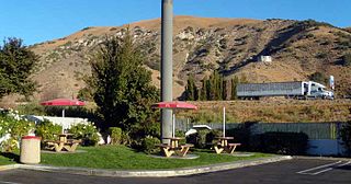
Frazier Park is an unincorporated community in Kern County, California. It is 5 miles (8 km) west of Lebec, at an elevation of 4,639 feet (1,414 m). It is one of the Mountain Communities of the Tejon Pass. The population was 2,691 in the 2010 census, up from 2,348 in 2000.

Lake of the Woods is an unincorporated area and census-designated place (CDP) in southwestern Kern County, California. As of the 2010 census the population was 917.

Lebec is an unincorporated area and census-designated place in southwestern Kern County, California. As of the 2010 census, the population was 1,468.

The Tehachapi Mountains are a mountain range in the Transverse Ranges system of California in the Western United States. The range extends for approximately 40 miles (64 km) in southern Kern County and northwestern Los Angeles County and form part of the boundary between the San Joaquin Valley and the Mojave Desert.

The Tejon Pass, previously known as Portezuelo de Cortes, Portezuela de Castac, and Fort Tejon Pass, is a mountain pass between the southwest end of the Tehachapi Mountains and northeastern San Emigdio Mountains, linking Southern California north to the Central Valley. It has been traversed by major roads such as the El Camino Viejo, the Stockton – Los Angeles Road, the Ridge Route, U.S. Route 99, and now Interstate 5.

The Ridge Route, officially the Castaic–Tejon Route, was a two-lane highway between Los Angeles County and Kern County, California. Opened in 1915 and paved with concrete between 1917 and 1921, the road was the first paved highway directly linking the Los Angeles Basin with the San Joaquin Valley over the Tejon Pass and the rugged Sierra Pelona Mountains ridge south of Gorman. Much of the old road runs through the Angeles National Forest, and passes many historical landmarks, including the National Forest Inn, Reservoir Summit, Kelly's Half Way Inn, Tumble Inn, and Sandberg's Summit Hotel. North of the forest, the Ridge Route passed through Deadman's Curve before ending at Grapevine.
Gorman is an unincorporated community in northwestern Los Angeles County. It is located in Peace Valley south of the Tejon Pass, which links Southern California with the San Joaquin Valley and Northern California. Due to this location, the area has served as a historic travel stop dating back to the indigenous peoples of California. Tens of thousands of motorists travel through Gorman daily on the Golden State Freeway since the highway's completion in the mid-20th Century.

Grapevine is an unincorporated community in Kern County, California, at the southern end of the San Joaquin Valley. The small village is directly adjacent to Interstate 5 and consists mainly of travelers' and roadside services. At an elevation of 1,499 feet (457 m), the community is located at the foot of a grade known as The Grapevine that starts at the mouth of Grapevine Canyon, immediately south of the community, and ascends the canyon to the Tejon Pass, which separates the Tehachapi Mountains from the San Emigdio Mountains via Interstate 5.

Fort Tejon in California is a former United States Army outpost which was intermittently active from June 24, 1854, until September 11, 1864. It is located in the Grapevine Canyon between the San Emigdio Mountains and Tehachapi Mountains. It is in the area of Tejon Pass along Interstate 5 in Kern County, California, the main route through the mountain ranges separating the Central Valley from the Los Angeles Basin and Southern California. The fort's location protected the San Joaquin Valley from the south and west.

Tejon Ranch Company, based in Lebec, California, is one of the largest private landowners in California. The company was incorporated in 1936 to organize the ownership of a large tract of land that was consolidated from four Mexican land grants acquired in the 1850s and 1860s by ranch founder General Edward Fitzgerald Beale.

Wheeler Ridge is an unincorporated community in the southwestern San Joaquin Valley, within Kern County, California. It is at the junction of the valley floor and the Wheeler Ridge landform of the Tehachapi Mountains.

Elizabeth Lake is a natural lake that lies directly on the San Andreas Fault in the northern Sierra Pelona Mountains, in northwestern Los Angeles County, southern California.

The Sierra Pelona, also known as the Sierra Pelona Ridge or the Sierra Pelona Mountains, is a mountain ridge in the Transverse Ranges in Southern California. Located in northwest Los Angeles County, the ridge is bordered on the north by the San Andreas fault and lies within and is surrounded by the Angeles National Forest.

The Old Santa Susana Stage Road, or Santa Susana Wagon Road, is a route taken by early travelers between the San Fernando Valley and Simi Valley near Chatsworth, California, via the Santa Susana Pass. The main route climbs through what is now the Santa Susana Pass State Historic Park, with a branch in Chatsworth Park South.
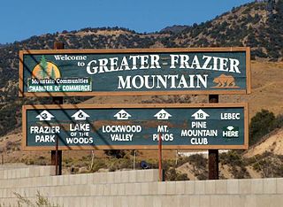
The Mountain Communities of the Tejon Pass, or the Frazier Mountain Communities, in the San Emigdio Mountains is a region of California that includes Lebec, Frazier Park, Lake of the Woods, Pinon Pines, and Pine Mountain Club, in Kern County, Gorman in Los Angeles County and Lockwood Valley within Kern and Ventura counties. They are all within or near the Tejon Pass, which links Southern California with the San Joaquin Valley. Also sometimes included within the communities are Cuddy Valley, Grapevine, Neenach and New Cuyama.
Rancho Castac or Rancho Castec was a 22,178-acre (89.75 km2) Mexican land grant in present-day Kern and Los Angeles counties, California, made by Governor Manuel Micheltorena to Jose Maria Covarrubias in 1843. The rancho in the Tehachapi Mountains lay between Castac Lake on the south and the present Grapevine on the north and included what is now the community of Lebec. The rancho is now a part of the Tejon Ranch.
The Stockton–Los Angeles Road, also known as the Millerton Road, Stockton–Mariposa Road, Stockton–Fort Miller Road or the Stockton–Visalia Road, was established about 1853 following the discovery of gold on the Kern River in Old Tulare County. This route between Stockton and Los Angeles followed by the Stockton–Los Angeles Road is described in "ITINERARY XXI. From Fort Yuma to Benicia, California", in The Prairie Traveler: A Hand-book for Overland Expeditions by Randolph Barnes Marcy. The Itinerary was derived from the report of Lieutenant R. S. Williamson on his topographical survey party in 1853, that was in search of a railroad route through the interior of California.
San Francisquito Pass is a mountain pass in the Sierra Pelona Mountains, located northeast of Green Valley and Santa Clarita, in northern Los Angeles County, California.
Tejon Creek, originally in Spanish Arroyo de Tejon, is a stream in Kern County, California. Its headwaters are located on the western slopes of the Tehachapi Mountains, and it flows northwest into the southern San Joaquin Valley.
Mud Spring, formerly called Aquaje Lodoso, is a spring and historic site in the western Antelope Valley, within northern Los Angeles County, southern California.
References
- 1 2 3 Durham, David L. (1998). California's Geographic Names: A Gazetteer of Historic and Modern Names of the State. Clovis, Calif.: Word Dancer Press. p. 1060. ISBN 1-884995-14-4.

| | This Kern County, California-related article is a stub. You can help Wikipedia by expanding it. |