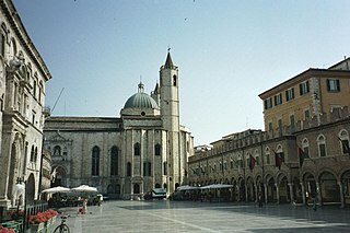
Ascoli Piceno is a town and comune in the Marche region of Italy, capital of the province of the same name. Its population is around 49,500 but the urban area of the city has more than 100,000.

Caliente is an unincorporated community in Kern County, California. It is located 22 miles (35 km) east-southeast of Bakersfield, at an elevation of 1,312 feet (400 m).

SS Emidio was a 6912-ton tanker of the Socony-Vacuum Oil Company, which became the first casualty of the Imperial Japanese Navy's submarine force action on California's Pacific Coast. It was one of four attacks on shipping, the others being Samoa, Larry Doheny, and Montebello, all attacked off the coast of California before Christmas. Emidio was sailing in ballast from Seattle, Washington en route to San Pedro, California. The Japanese submarine I-17 found Emidio off Cape Mendocino on the early afternoon of 20 December 1941, immediately attacking with its 14-cm deck gun. Realizing that the situation was futile, Captain Farrow raised a white flag and gave the order to abandon ship. Ignoring the surrender, the I-17 continued firing from its deck gun, blasting three crew members who were lowering a lifeboat overboard. Four crew members remained on board: a radio operator and three engineers. When the I-17 fired a torpedo, it struck the engine room and killed two of the engineers and injured the third. In total the I-17 hit the tanker with five shells from its 14-cm deck gun and one torpedo killing five crew members. A Catalina flying boat of 44 Patrol Squadron attacked I-17 with depth charges, but the submarine dove and escaped. The Coast Guard Cutter Shawnee rescued the remaining 31 survivors who had rowed 16 hours to Humboldt Bay. The abandoned tanker drifted north and broke up on the rocks off Crescent City. The bow drifted into the harbor, where it lay until scrapped in 1959. The remains of the hull are still in the harbor, near a commemorative plaque. The site has been declared a California Historical Landmark #497.

Saint Emygdius was a Christian bishop who is venerated as a martyr. Tradition states that he was killed during the persecution of Diocletian.

Mount San Jacinto State Park is in the San Jacinto Mountains, of the Peninsular Ranges system, in Riverside County, California, United States. A majority of the park is within the Santa Rosa and San Jacinto Mountains National Monument. The park is near the Greater Los Angeles and the San Diego metropolitan area.

The Fox Range is a mountain range in east central Washoe County, Nevada.
The Selenite Range is a mountain range in western Pershing County, Nevada. The range is a north–south trending feature approximately 27 miles (43 km) long and 4 miles (6.4 km) wide.
Panama, formerly named Rio Bravo after the Spanish name for the Kern River, Rio Bravo de San Felipe, is an unincorporated community in Kern County, California. It is located 8 miles (13 km) south-southwest of Bakersfield, at an elevation of 351 feet (107 m) in the San Joaquin Valley.

Achois is a former Tongva Indian settlement in the San Fernando Valley of Los Angeles County, California.
Azucsagna is a former Tongva-Gabrieleño Californian Native American settlement in the San Gabriel Valley. The site is in Los Angeles County, California.
Isanthcogna is a former Tongva-Gabrieleño Native American settlement in Los Angeles County, California.
Docas is a former settlement in Monterey County, California. It was located on the Southern Pacific Railroad 5 miles (8 km) north-northwest of San Ardo, at an elevation of 404 feet. It still appeared on USGS maps as of 1943.

Coyote Creek is a stream in the Richardson Bay watershed, draining Tamalpais-Homestead Valley, California eastward into Richardson Bay, Marin County, California, United States. The stream originates on Coyote Ridge and flows 2.5 miles (4.0 km) to the bay at the south end of Bothin Marsh.
Rancho San Emidio was a 17,710-acre (71.7 km2) Mexican land grant in present-day Kern County, California given in 1842 by Governor Juan Alvarado to José Antonio Dominguez. The grant was located along San Emigdio Creek in the northeastern foothills of the San Emigdio Mountains, between Santiago Creek on the west and Pleitito Creek on the east.
Cuddy Valley is a valley in the San Andreas Rift Zone south of the San Emigdio Mountains west of Tejon Pass, and unincorporated community in Kern County, California, and part of the Mountain Communities. It lies at an elevation of 5,282 feet 1610 m).

San Emigdio Creek, formerly Arroyo de San Emigdio, is a 33 kilometres (21 mi) northward-flowing stream in western Kern County, central California.
San Emidio Geothermal Plant, in Washoe County, Nevada, is a geothermal power plant with a design capacity of 11.8 megawatts (15,800 hp). The upgraded plant went online on May 25, 2012.
Emidio is a given name. Notable people with the name include:
Jesus Valenzuela, also known as Joaquin Ocomorenia, the alias used by him as a member of the Five Joaquins Gang, born in Pueblo de Murrieta, he was the brother of Joaquin and Teodoro Valezuela and was like them a cousin of Joaquin Murrieta and his brothers and other Murrieta cousins. He came to California in 1849 with his brothers, Joaquin Murrieta and his brothers and cousins.


