
Redrock Crossing is an unincorporated community on the Potomac River in Morgan County in the U.S. state of West Virginia's Eastern Panhandle. Redrock Crossing lies on River Road between the communities of Hancock and Sleepy Creek.

Merrimac is an unincorporated community in Butte County, California located along Oroville-Quincy Road about 2.1 miles (3.4 km) south of the Plumas County line. It lies at an elevation of 3999 feet. While the location is shown as official in the National Geographic Names Database, it is not known if locals use this name to describe the place today. Nearby is Rogers Cow Camp, a campground in Lassen National Forest. The USGS feature ID for this populated place is 1659117. The US Postal Service does not show a ZIP Code for this community. The location is within area code 530.

The Sierra Pelona Mountains, or the Sierra Pelona Ridge, is a mountain range of the Transverse Ranges in Southern California. Located in northwest Los Angeles and southern Kern Counties, the range is bordered on the north by the San Andreas fault and lies within and is surrounded by the Angeles National Forest.
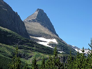
Mount Grinnell is a peak located in the heart of Glacier National Park in the U.S. state of Montana. Lying just east of the Continental Divide in the Many Glacier region of the park, the peak is flanked to the northwest by Swiftcurrent Glacier and to the south by Grinnell Glacier. Mount Grinnell is named after George Bird Grinnell. From the Many Glacier Hotel on Swiftcurrent Lake, the eastern arm of Mount Grinnell, known as Grinnell Point, hides the main summit.

East Biggs is a small unincorporated community in Butte County, California. Its zip code is 95917 and its area code is 530. It lies at an elevation of 121 feet.
Dayton is a small unincorporated community in Butte County, California. Its zip code is 95928 and its area code is 530. It lies at an elevation of 141 feet.

Redrock Mountain Natural Area Preserve is a 640-acre (260 ha) Natural Area Preserve located in Smyth County, Virginia. The preserve is named for the 4,413-foot (1,345 m) Redrock Mountain, which itself is named for its red siltstone cliffs. It supports a number of rare natural features, and two natural community types, including examples of "mountain/piedmont basic woodlands" upon the mountain's slopes, and "rich cove/slope forests" in the preserve's lowlands. Five rare plant species are found on the property, including spring blue-eyed Mary, fringed scorpion-weed, and Carey saxifrage.
Wicks Corner is an unincorporated community in Butte County, California, at the junction of California State Route 70 and California State Route 149. It lies at an elevation of 272 feet.
Blackwells Corner is an unincorporated community in the Antelope Valley of Kern County, California. It is located 50 miles (80 km) west-northwest of Bakersfield, at an elevation of 650 feet. Blackwells Corner is at the intersection of California State Route 46 and California State Route 33, and was the last place James Dean was seen alive prior to his death in a car wreck.
Cambio is a former settlement in Kern County, California. It was located on the Southern Pacific Railroad 4 miles (6.4 km) northeast of Mojave, at an elevation of 2835 feet. Cambio still appeared on maps as of 1947.
Desert Lake is an unincorporated community in Kern County, California.
{{Infobox settlement |name = Jastro Winkle |other_name = Jastro Winkle,California 93308 |native_name = Jastro Diamond |nickname = Jastro Diamond Field |settlement_type =[[Sovereign State] [unincorporated]] |image_skyline = |imagesize = |image_caption = |pushpin_map =California#USA |pushpin_label_position =bottom |pushpin_mapsize = |pushpin_map_caption =Location in California |pushpin_image=California Locator Map with US.PNG |subdivision_type = Country |subdivision_name =United States |subdivision_type1 = State |subdivision_name1 = California |subdivision_type2 =County |subdivision_name2 = Kern County |subdivision_type3 = |subdivision_name3 = | |established_title = |established_date = |coordinates = 35°22′36″N119°04′20″W |elevation_footnotes = |elevation_m =121 |elevation_ft =397 |footnotes =Jastro Winkle, California is the 14 acre site where Mr. H.A. Jastro established a designated Autonomous Electoral District in Kern County California. The Community is situated atop of a Kimberley Pipe and is also known as the Center of the Oil Patch }} Jastro also known as Winkle is an unincorporated community in Kern County, California. It is located on the Atchison, Topeka and Santa Fe Railroad 4 miles (6.4 km) west of Bakersfield, at an elevation of 397 feet.
Magunden is an unincorporated community in Kern County, California. It is located 4 miles (6.4 km) east of downtown Bakersfield, at an elevation of 440 feet.
Ricardo is an unincorporated community in Kern County, California.
Twin Lakes is an unincorporated community in Kern County, California. It is located 4 miles (6.4 km) east-northeast of Liebre Twins, at an elevation of 5,171 feet (1,576 m).
Glenblair is an unincorporated community in Mendocino County, California. It is located 15 miles (24 km) north-northwest of Comptche, at an elevation of 207 feet.
Tatu is an unincorporated community in Mendocino County, California. It is located on the Eel River adjacent to the Northwestern Pacific Railroad and California State Route 1624 miles (6.4 km) south of Dos Rios, at an elevation of 971 feet.
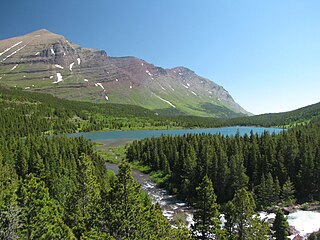
Redrock Lake is located in Glacier National Park, in the U. S. state of Montana. Mount Wilbur is west of Redrock Lake. Prior to entering Redrock Lake, Swiftcurrent Creek tumbles over Redrock Falls which can be reached after an easy 1.8 miles (2.9 km) hike by way of the Swiftcurrent Pass Trail.

Redrock is an unincorporated community located in Grant County, New Mexico, United States. The community is located on the Gila River and New Mexico State Road 464 27.3 miles (43.9 km) west-southwest of Silver City.


