Related Research Articles

Bear Valley Springs is a guarded-gate community in Kern County, California, United States. Bear Valley Springs is in the Tehachapi Mountains and is part of the greater Tehachapi area. The elevation ranges from 4,121 feet (1,256 m) to 6,934 feet (2,113 m). The population fluctuates between a low during the winter months when snow is common, to a high in the summer months when its elevation keeps it much cooler than surrounding areas and major cities. The population was 5,172 at the 2010 census, up from 4,232 at the 2000 census. For statistical purposes, the United States Census Bureau has defined Bear Valley Springs as a census-designated place (CDP). The census definition of the area may not precisely correspond to local understanding of the area with the same name.

Keene is a census-designated place (CDP) in Kern County, California in the foothills of the Tehachapi Mountains at the southern extreme of the San Joaquin Valley. Keene is located 8.5 miles (14 km) northwest of Tehachapi, at an elevation of 2,602 feet (793 m). The population was 431 at the 2010 census, up from 339 at the 2000 census.

Tehachapi is a city in Kern County, California, in the Tehachapi Mountains, at an elevation of 3,970 feet (1,210 m) between the San Joaquin Valley and the Mojave Desert.
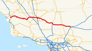
State Route 58 is a major east-west state highway in the U.S. state of California that runs across the Coast Ranges, the southern San Joaquin Valley, the Tehachapi Mountains, which border the southern Sierra Nevada, and the Mojave Desert. It runs between U.S. Route 101 near Santa Margarita and Interstate 15 in Barstow. It has junctions with Interstate 5 near Buttonwillow, State Route 99 in Bakersfield, State Route 202 in Tehachapi, State Route 14 near Mojave, and U.S. Route 395 at Kramer Junction. SR 58 also provides access to Edwards Air Force Base. At various points it is known as the Calf Canyon Highway, Carrisa Highway, Bakersfield-McKittrick Highway, Rosa Parks Highway, Rosedale Highway, Barstow-Bakersfield Highway, Kern County Korean War Veterans Memorial Highway, and Mojave-Barstow Highway.

The Tehachapi Mountains are a mountain range in the Transverse Ranges system of California in the Western United States. The range extends for approximately 40 miles (64 km) in southern Kern County and northwestern Los Angeles County.

The Tehachapi Loop is a 3,779 feet long spiral, or helix, on the Union Pacific Railroad Mojave Subdivision through Tehachapi Pass, of the Tehachapi Mountains in Kern County, south-central California. The line connects Bakersfield and the San Joaquin Valley to Mojave in the Mojave Desert.

Tehachapi Pass is a mountain pass crossing the Tehachapi Mountains in Kern County, California. Traditionally, the pass marks the northeast end of the Tehachapis and the south end of the Sierra Nevada range.
Caliente is an unincorporated community in Kern County, California. It is located 22 miles (35 km) east-southeast of Bakersfield, at an elevation of 1,312 feet (400 m).

The Tehachapi Pass wind farm is one of the first large-scale wind farms installed in the U.S., with around 710 megawatts (950,000 hp) produced by about 3400 wind turbines.

Mountain Valley Airport is a privately owned public-use airport located two nautical miles southeast of the central business district of Tehachapi, in Kern County, California, United States.

Cameron is an unincorporated community in the Tehachapi Mountains, in Kern County, California. It is located on the Union Pacific Railroad 9 miles (14 km) east-southeast of Tehachapi, at an elevation of 3,802 feet (1,159 m).
Loraine is an unincorporated community in Kern County, California. It is located on the east bank of the mouth of Indian Creek where it enters Caliente Creek, 12 miles (19.3 km) north of Tehachapi, at an elevation of 2,671 feet (814 m).

Monolith is an unincorporated community in the Tehachapi Valley, in Kern County, California.
Old Town is an unincorporated community in Kern County, California. It is located 3 miles (4.8 km) west-northwest of Tehachapi, at an elevation of 3829 feet.
Sand Canyon is an unincorporated community in Kern County, California. It is located on Cache Creek 7 miles (11 km) east of Tehachapi, at an elevation of 4,500 feet (1,400 m).
Greenwich is a former settlement in Kern County, California. It was located 3 miles (4.8 km) east of Old Town, near the modern-day site of Tehachapi.
Desert Spring is a former settlement in Kern County, California in the Fremont Valley, south of Red Rock Canyon State Park. It was located 1.5 miles (2.4 km) northeast of Cantil. About .8 miles norht of California State Route 58 on Bellville Road at the railroad tracks.
Water Station is a former settlement in Kern County, California.
Mill City is a former settlement in Mono County, California. It was located 8.5 miles (14 km) west-northwest of Mount Morrison and 0.5 miles (0.8 km) southwest of Old Mammoth, at an elevation of 8320 feet.
Tejon Creek, originally in Spanish Arroyo de Tejon, is a stream in Kern County, California. Its headwaters are located on the western slopes of the Tehachapi Mountains, and it flows northwest into the southern San Joaquin Valley.
References
- 1 2 Durham, David L. (1998). California's Geographic Names: A Gazetteer of Historic and Modern Names of the State. Clovis, Calif.: Word Dancer Press. p. 1011. ISBN 1-884995-14-4.

| This Kern County, California-related article is a stub. You can help Wikipedia by expanding it. |