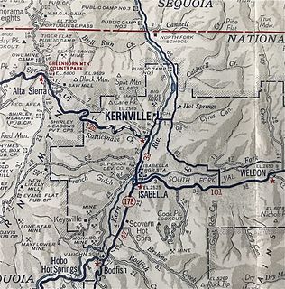
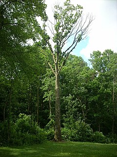
Kernville is a census-designated place (CDP) in the southern Sierra Nevada, in Kern County, California, United States. Kernville is located 42 miles (68 km) northeast of Bakersfield, at an elevation of 2,667 feet (813 m). The population was 1,395 at the 2010 census, down from 1,736 at the 2000 census.

Lake Isabella is a census-designated place (CDP) in the southern Sierra Nevada, in Kern County, California, United States. It is named after the Lake Isabella reservoir and located at its southwestern edge, 6 miles (9.7 km) south of Wofford Heights in the Kern River Valley.
Wofford Heights is a census-designated place (CDP) in the southern Sierra Nevada, in Kern County, California, United States. Wofford Heights is located in the west Kern River Valley, 3.5 miles (5.6 km) south-southwest of Kernville, at an elevation of 2,684 feet (818 m). The population was 2,200 at the 2010 census, down from 2,276 at the 2000 census.
Lakeport is an incorporated city and county seat of Lake County, California. This city is one hundred and twenty-five miles northwest of Sacramento. Lakeport is on the west shore of Clear Lake, at an elevation of 1355 feet. The population was 4,753 at the 2010 census, down from 4,820 at the time of the 2000 census.
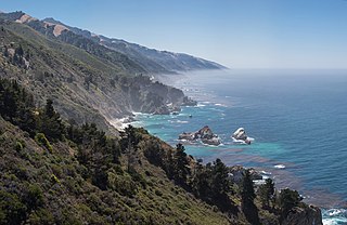
Big Sur is a rugged and mountainous section of the Central Coast of California between Carmel Highlands and San Simeon, where the Santa Lucia Mountains rise abruptly from the Pacific Ocean. It is frequently praised for its dramatic scenery. Big Sur has been called the "longest and most scenic stretch of undeveloped coastline in the contiguous United States," a "national treasure that demands extraordinary procedures to protect it from development" and "one of the most beautiful coastlines anywhere in the world, an isolated stretch of road, mythic in reputation." The stunning views, redwood forests, hiking, beaches, and other recreational opportunities have made Big Sur a popular destination for about 7 million people who live within a day's drive and visitors from across the world. The region receives about the same number of visitors as Yosemite National Park, but offers extremely limited bus service, few restrooms, and a narrow two-lane highway with few places to park alongside the road. North-bound traffic during the peak summer season and holiday weekends is often backed-up for about 20 miles (32 km) from Big Sur Village to Carmel.

Ahjumawi Lava Springs State Park is a state park of California in the United States. It is located in remote northeastern Shasta County and is only accessible to the public by boat.
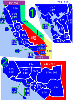
Area code 760 is a California telephone area code that was split from area code 619 on March 22, 1997. Area code 442 is an overlay of 760 that became effective on November 21, 2009. It encompasses much of the southeastern and southernmost portions of California. The area includes Imperial, Inyo, and Mono counties, as well as portions of San Diego, Riverside, San Bernardino, Los Angeles and Kern counties.

Lake Isabella also called Isabella Lake, is a reservoir in Kern County, California, United States created by the earthen Isabella Dam. It was formed in 1953 when the U.S. Army Corps of Engineers dammed the Kern River at the junction of its two forks at Whiskey Flat. At 11,000 acres (4,500 ha), it is one of the larger reservoirs in California. The area is in the southern end of the Sierra Nevada range and the lake itself is located in low mountains at an elevation of approximately 2,500 ft (760 m) where summer temperatures reach over 100 °F (38 °C) but low enough to avoid winter snows on the surrounding ridges. Lake Isabella is located about 40 miles (64 km) northeast of Bakersfield, and is the main water supply for that city. Lake Isabella can be reached by car from Bakersfield via state Highway 178 and from Delano via Highway 155. The former towns of Isabella and Kernville were flooded by the newly created reservoir.

Stanislaus National Forest is a United States national forest which manages 898,099 acres of land in four counties in the Sierra Nevada in Northern California. It was established on February 22, 1897, making it one of the oldest national forests. It was named after the Stanislaus River.

Kernville is an unincorporated community in Lincoln County, Oregon, United States. It is located near the intersection of U.S. Route 101 and Oregon Route 229, where the Siletz River enters Siletz Bay. There are two communities, known as "old" and "new" Kernville, in close proximity. Old Kernville is considered a ghost town.
Boyd Big Tree Preserve Conservation Area is a 949.49-acre (384.24 ha) Pennsylvania state park in Lower Paxton and Middle Paxton Townships, Dauphin County, Pennsylvania in the United States. The land for the conservation area was donated to the state by real estate developer Alex Boyd in 1999. Boyd Big Tree Preserve Conservation Area is a sanctuary for mature trees and an environment education study area. The park is on Blue Mountain just off Pennsylvania Route 443.

Julia Pfeiffer Burns State Park is a state park in California, 12 miles south of Pfeiffer Big Sur State Park on California's Pacific coast. A main feature of the park is McWay Falls, which drops over a cliff of 80 feet (24 m) into the Pacific Ocean. The park is also home to 300-foot (90 m) redwoods which are over 2,500 years old. The park is named after Julia Pfeiffer Burns, a respected resident and rancher in the Big Sur region in the early 20th century, who lived in the area for much of her life until her death in 1928. The 3,762-acre (1,522 ha) park was established in 1962.
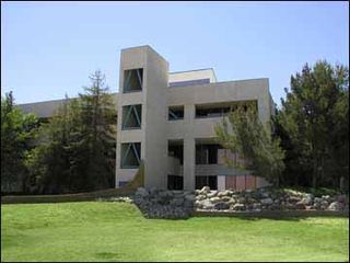
Cerro Coso Community College is a community college in the Eastern Sierra region of Southern California. It was established in 1973 as a separate college within the Kern Community College District. The college offers traditional and online courses and two-year degrees. The college serves an area of approximately 18,000-square-miles. Cerro Coso has five instructional sites: Eastern Sierra Center Bishop & Mammoth, Indian Wells Valley, Kern River Valley, and South Kern.

Big Lagoon is a census-designated place in Humboldt County, California. It is located 7 miles (11 km) north of Trinidad, at an elevation of 56 feet. The population was 93 at the 2010 census.

Camp Owens is an unincorporated community in the Kern River Valley of the Southern Sierra Nevada, in Kern County, California.
Glennville is an unincorporated community in Kern County, California.
Rogersville is a former settlement in Kern County, California. It was located 1 mile (1.6 km) north of Kernville. The place was named for Lovely Rogers who discovered gold nearby in 1861.
Quartzburg is a former settlement in Kern County, California. It was located 1 mile (1.6 km) north of Kernville. In 1873, Quartzburg was founded as a mining camp after gold production increased nearby.
Burkeville is a former settlement in Kern County, California. It was located 0.5 miles (0.8 km) north of Quartzburg. Burkeville began as a mining camp and was named for Edwin Burke, co-owner of the Big Blue Mine.