
Wallace is a census-designated place (CDP) at the far west edge of Calaveras County, California, United States on State Route 12. The population was 403 at the 2010 census, up from 220 at the 2000 census.

The Wallace Line or Wallace's Line is a faunal boundary line drawn in 1859 by the British naturalist Alfred Russel Wallace and named by English biologist Thomas Henry Huxley, that separates the ecozones of Asia and Wallacea, a transitional zone between Asia and Australia. West of the line are found organisms related to Asiatic species; to the east, a mixture of species of Asian and Australian origin is present. Wallace noticed this clear division during his travels through the East Indies in the 19th century.

Mount Whitney is the tallest mountain in California, as well as the highest summit in the contiguous United States and the Sierra Nevada—with an elevation of 14,505 feet (4,421 m). It is in Central California, on the boundary between California's Inyo and Tulare counties, 84.6 miles (136.2 km) west-northwest of the lowest point in North America at Badwater Basin in Death Valley National Park at 282 ft (86 m) below sea level. The west slope of the mountain is in Sequoia National Park and the summit is the southern terminus of the John Muir Trail which runs 211.9 mi (341.0 km) from Happy Isles in Yosemite Valley. The east slope is in the Inyo National Forest in Inyo County.

California Baptist University is a private, Christian, liberal arts university in Riverside, California. Founded in 1950 as California Baptist College, it is affiliated with the California Southern Baptist Convention, an organization affiliated with the Southern Baptist Convention. CBU is accredited by the Western Association of Schools and Colleges.
DeWitt Wallace, was an American magazine publisher.

Cantil is an unincorporated community in Kern County, California. It is in the Fremont Valley of the western Mojave Desert.
Ravendale is an unincorporated community in Lassen County, California. It is located 7 miles (11 km) southeast of Termo, at an elevation of 5305 feet. According to Rand McNally, it is 54 driving miles to the county seat, Susanville, the only city in the county, and about the same distance to Alturas.

The Californias, occasionally known as the Three Californias or Two Californias, are a region of North America spanning the United States and Mexico and consisting of the U.S. state of California and the Mexican states of Baja California and Baja California Sur. Historically, the term "The Californias" was used to define the vast northwestern region of Spanish America, as the Province of the Californias, and later as a collective term for Alta California and the Baja California Peninsula.

Atsushi Wallace Tashima is a Senior United States Circuit Judge of the United States Court of Appeals for the Ninth Circuit and a former United States District Judge of the United States District Court for the Central District of California. He is the third Asian American and first Japanese American to be appointed to a United States Court of Appeals.
Pinacate, was a small settlement east of the Pinacate Mining District in Riverside County, California. It was established when the California Southern Railroad line was built between Colton and San Diego in 1882. Due to a land title dispute the town was moved to the north to become Perris, California, in 1885.
John Clifford Wallace is a Senior United States Circuit Judge of the United States Court of Appeals for the Ninth Circuit and previously was a United States District Judge of the United States District Court for the Southern District of California.
Herndon is an unincorporated community in Fresno County, California. It is located 9 miles (14 km) northwest of downtown Fresno, at an elevation of 299 feet.

Pumpkin Center is an unincorporated community in Kern County, California. It is located 7.5 miles (12 km) south-southwest of Bakersfield, at an elevation of 351 feet (107 m).
Pumpkin Center is an unincorporated community in Lassen County, California. It is located 2.25 miles (3.6 km) east-southeast of Bieber, at an elevation of 4134 feet.
Antelope Center is an unincorporated community in the Antelope Valley of the western Mojave Desert, in northern Los Angeles County, California.
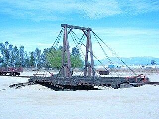
Poverty Bar is a former settlement in Calaveras County, California now covered by the waters of Camanche Reservoir. Poverty Bar is located at latitude - longitude coordinates of N 38.22547 and W -120.90938. Poverty Bar is shown in the center of the topographic (topo) map, which is sourced from the United States Geographical Survey map USGS WALLACE quad. The nearest major town is Campo Seco, California.
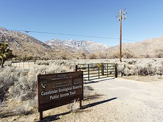
Canebrake Ecological Reserve is a 6,700-acre (27 km2) nature reserve in the South Fork Valley of Kern County, 20 miles (32 km) east of Lake Isabella, California. It is located in the Southern Sierra Nevada region.
The 1968 United States presidential election in Virginia took place on November 5, 1968. All fifty states and the District of Columbia were part of the 1968 United States presidential election. Virginia voters chose twelve electors to the Electoral College, which selected the president and vice president of the United States.

Whites Bridge or Whitesbridge is a former settlement on the Fresno Slough near Tranquillity in Fresno County, California.

The 1968 United States presidential election in Georgia was held on November 5, 1968. American Independent Party candidate George Wallace received the most votes, and won all twelve of the state’s electoral college votes.


