
Fram ("Forward") is a ship that was used in expeditions of the Arctic and Antarctic regions by the Norwegian explorers Fridtjof Nansen, Otto Sverdrup, Oscar Wisting, and Roald Amundsen between 1893 and 1912. It was designed and built by the Scottish-Norwegian shipwright Colin Archer for Fridtjof Nansen's 1893 Arctic expedition in which the plan was to freeze Fram into the Arctic ice sheet and float with it over the North Pole.
The Fleet Rehabilitation and Modernization (FRAM) program of the United States Navy extended the lives of World War II-era destroyers by shifting their mission from a surface attack role to that of a submarine hunter. The FRAM program also covered cruisers, aircraft carriers, submarines, amphibious ships, and auxiliaries. The United States Coast Guard also used this term in the 1980s for the modernization of its Hamilton-class cutters.

The Gearing class was a series of 98 destroyers built for the U.S. Navy during and shortly after World War II. The Gearing design was a minor modification of the Allen M. Sumner class, whereby the hull was lengthened by 14 ft (4.3 m) at amidships, which resulted in more fuel storage space and increased the operating range.

Fram is an impact crater located within the Meridiani Planum extraterrestrial plain, situated within the Margaritifer Sinus quadrangle (MC-19) region of the planet Mars. It was visited by the rover Opportunity (MER-B) on Sol 84, April 24, 2004.
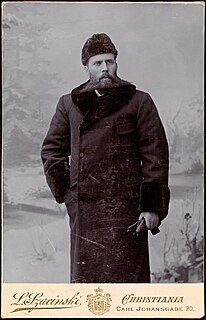
Otto Neumann Knoph Sverdrup was a Norwegian sailor and Arctic explorer.
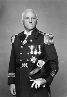
Oscar Adolf Wisting was a Norwegian Naval officer and polar explorer. Together with Roald Amundsen he was the first person to reach both the North and South Poles.
Results from Norwegian football in 1931. See also 1930 in Norwegian football and 1932 in Norwegian football
The Fram was an arctic exploration vessel from Norway. Fram may also refer to:

The Úrvalsdeild karla is the highest football league in Iceland. It has been played since 1912. Because of the harsh winters in Iceland, it is generally played in the spring and summer. It is administered by the Football Association of Iceland (KSI) and is contested by 12 teams. At the end of the 2015–2016 season, the UEFA ranked the league 35th in Europe. From 27 April 2009, the league has been known as Pepsi deildin due to a three-year sponsorship deal with Ölgerðin.
Hansen Mountains is a large group of nunataks rising to about 300 m (980 ft) above the Antarctic plateau. The mountains are approximately 89 km (55 mi) south of Stefansson Bay and they extend 40 km (25 mi) from northwest to southeast in Kemp Land, East Antarctica. The Hansen Mountains were first mapped by Norwegian cartographers from air photos taken by the 1936–1937 Lars Christensen Expedition. They were named for H.E. Hansen, the Norwegian cartographer who compiled the maps for this and other Norwegian Antarctic expeditions.
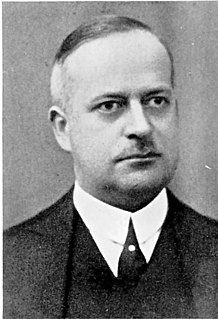
Lars Christensen was a Norwegian shipowner and whaling magnate. He was also a philanthropist with a keen interest in the exploration of Antarctica.

Knattspyrnufélagið Fram is an Icelandic sports club, best known for its football and handball teams. It was founded on 1 May 1908 in Reykjavík. It is based at Safamýri, in the Háaleiti og Bústaðir district near Reykjavík city centre.
An ExPRESS logistics carrier (ELC) is an unpressurized attached payload platform for the International Space Station (ISS) that provides mechanical mounting surfaces, electrical power, and command and data handling services for Orbital Replacement Units (ORUs) as well as science experiments on the ISS. The ELCs were developed primarily at the Goddard Space Flight Center in Greenbelt, Maryland, with support from JSC, KSC, and MSFC. ELC was formerly called "Express Pallet" and is the unpressurized counterpart to the pressurized ExPRESS Rack. An ELC provides scientists with a platform and infrastructure to deploy experiments in the vacuum of space without requiring a separate dedicated Earth-orbiting satellite.

The Fram Strait is the passage between Greenland and Svalbard, located roughly between 77°N and 81°N latitudes and centered on the prime meridian. The Greenland and Norwegian Seas lie south of Fram Strait, while the Nansen Basin of the Arctic Ocean lies to the north. Fram Strait is noted for being the only deep connection between the Arctic Ocean and the World Oceans. The dominant oceanographic features of the region are the West Spitsbergen Current on the east side of the strait and the East Greenland Current on the west.
Reservoir is a former settlement in Kern County, California. It was located on the Southern Pacific Railroad 1 mile (1.6 km) south-southeast of Fram.

Nansen's Fram expedition of 1893–96 was an attempt by the Norwegian explorer Fridtjof Nansen to reach the geographical North Pole by harnessing the natural east–west current of the Arctic Ocean. In the face of much discouragement from other polar explorers, Nansen took his ship Fram to the New Siberian Islands in the eastern Arctic Ocean, froze her into the pack ice, and waited for the drift to carry her towards the pole. Impatient with the slow speed and erratic character of the drift, after 18 months Nansen and a chosen companion, Hjalmar Johansen, left the ship with a team of dogs and sledges and made for the pole. They did not reach it, but they achieved a record Farthest North latitude of 86°13.6′N before a long retreat over ice and water to reach safety in Franz Josef Land. Meanwhile, Fram continued to drift westward, finally emerging in the North Atlantic Ocean.

MS Fram is a passenger vessel operated by the Norway-based Hurtigruten Group. The ship is named after the original Fram, the ship used by explorers Fridtjof Nansen and Roald Amundsen. The ship operates in the Arctic Ocean and around Greenland in the summer, and cruises around Antarctica at other times of the year. In December 2007, the ship lost power and struck a glacier in Antarctica, sustaining damage to the starboard side; the collision did not affect the ship's seaworthiness.

The Fram Islands are a small group of rocky islands and rocks in the western portion of the Geologie Archipelago, 4 kilometres (2 nmi) north-northwest of Cape Geodesie. They were photographed from the air by U.S. Navy Operation Highjump, 1946–47, charted by the French Antarctic Expedition, 1949–51, and named by them for the Norwegian polar ship Fram, used by Fridtjof Nansen in the Arctic and Roald Amundsen in the Antarctic.
Fram Mesa is a high, ice-capped mesa, 10 nautical miles (19 km) long and 1 to 3 nautical miles wide, that forms the northeastern portion of Nilsen Plateau in the Queen Maud Mountains of Antarctica. The feature may have been seen by Amundsen in 1911, and it was observed and partially mapped by the Byrd Antarctic Expeditions of 1928–30 and 1933–35. It was mapped in detail by the United States Geological Survey from surveys and U.S. Navy air photos, 1960–64, and was named by the Advisory Committee on Antarctic Names after the Fram, the ship used by Amundsen's South Pole expedition of 1910–12.

The Nansen Basin is an abyssal plain with water-depths of around 3 km in the Arctic Ocean and part of the Eurasian Basin. It is named after Fridtjof Nansen. The Nansen Basin is bounded by the Gakkel Ridge on the one side and by the Barents Sea continental shelf on the other.


