
State Route 33 is a north–south state highway in the U.S. state of California. It runs north from Ventura through the Transverse Ranges and the western side of the San Joaquin Valley to a point east of Tracy. SR 33 replaced part of U.S. Route 399 in 1964 during the "great renumbering" of routes. In the unincorporated sections of Kern County it is known as the West Side Highway. In addition, the California Legislature designated the entire Kern County portion as the Petroleum Highway in 2004. The southernmost portion in Ventura is a freeway known as the Ojai Freeway, while it is known as the Maricopa Highway from Ojai to Maricopa.

Beldon is a small suburb of Perth, Western Australia, located within the City of Joondalup, to the north of Craigie.
Craigie is a northern suburb of Perth. Craigie was chosen as a suburb name in 1970 and honours an early councillor of the City of Wanneroo who did work in developing the City. Craigie is one of the four "Whitfords" suburbs that resulted from the State Government rezoning a large area of coastal land for development in 1969.
Heathridge is a suburb of Perth, Western Australia, located 6 kilometres (4 mi) south of Yanchep within the City of Joondalup.

Belridge Secondary College, formerly Belridge Senior High School, is a comprehensive co-educational state high school located in Beldon, 3.8 kilometres (2.4 mi) south of Joondalup in the northern suburbs of Perth, Western Australia.

The Temblor Range is a mountain range within the California Coast Ranges, at the southwestern extremity of the San Joaquin Valley in California in the United States. It runs in a northwest-southeasterly direction along the borders of Kern County and San Luis Obispo County. The name of the range is from the Spanish word for "earthquake" (terremoto). The San Andreas Fault Zone runs parallel to the range at the base of its western slope, on the eastern side of the Carrizo Plain, while the Antelope Plain, location of the enormous Midway Sunset, South Belridge, and Cymric oil fields, lies to the northeast.

Padbury Senior High School was a government, co-educational, secondary day school located in Padbury, a suburb north of Perth, Western Australia.

The Buck Institute for Research on Aging is an independent biomedical research institute that researches aging and age-related disease. The mission of the Buck Institute is to extend the healthy years of life.
Aera Energy LLC (Aera) is a natural gas, oil exploration and production company jointly owned by Shell Oil Company and ExxonMobil headquartered in Bakersfield, California. In addition, Aera Energy LLC is a California limited liability company, and one of California’s largest oil and natural gas producers, with an approximate 2015 revenues of over $2 billion. Aera is operated as a stand-alone company through its board of managers.1

The South Belridge Oil Field is a large oil field in northwestern Kern County, San Joaquin Valley, California, about forty miles west of Bakersfield. Discovered in 1911, and having a cumulative production of over 1,500 million barrels (240,000,000 m3) of oil at the end of 2008, it is the fourth-largest oil field in California, after the Midway-Sunset Oil Field, Kern River Oil Field, and Wilmington Oil Field, and is the sixth-most productive field in the United States. Its estimated remaining reserves, as of the end of 2008, were around 494 million barrels (78,500,000 m3), the second-largest in the state, and it had 6,253 active wells. The principal operator on the field was Aera Energy LLC, a joint venture between Royal Dutch Shell and ExxonMobil. Additionally, the field included the only onshore wells in California owned and operated by ExxonMobil.

The Kettleman North Dome Oil Field is a large oil and gas field in Kings and Fresno counties, California. Discovered in 1928, it is the fifteenth largest field in the state by total ultimate oil recovery, and of the top twenty oil fields it is the closest to exhaustion, with less than one-half of one percent of its original oil remaining in place.

Missouri Triangle is an unincorporated community in Kern County, California. It is located 10 miles (16 km) north of McKittrick, at an elevation of 561 feet (171 m).

The North Belridge Oil Field is a large oil field along California State Route 33 in the northwestern portion of Kern County, California, about 45 miles west of Bakersfield. It is contiguous with the larger South Belridge Oil Field to the southeast, in a region of highly productive and mature fields. Discovered in 1912, it has had a cumulative production of 136,553,000 barrels (21,710,200 m3) of oil, and retains 27,443,000 barrels (4,363,100 m3) in reserve, as of the end of 2006, making it the 40th largest oil field in the state.
Chico Martinez Creek, formerly Arroyo Chico Martinez is a stream with its source located in the Temblor Range in Kern County, California near to the San Luis Obispo County boundary. Its source is located 10.7 miles north of Soda Lake, California in the middle of the Carrizo Plain. The creek runs generally east and northeast to terminate just east of the South Belridge Oil Field. In years of heavy rainfall it may have been a tributary to the Kern River between Buena Vista Lake and Tulare Lake.
Aguaje Mesteño or Mustang Springs, is a watering place along El Camino Viejo, on Chico Martinez Creek, formerly Arroyo Chico Martinez. The springs are located in Kern County, California, United States.

GlassPoint Solar is a private company founded in 2009 that designs and manufactures solar steam generators that use solar thermal technology to generate steam for industrial processes.
Dolly Green was an American heiress, philanthropist and thoroughbred owner.
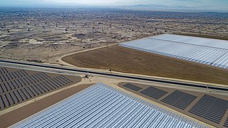
Belridge Solar is an enhanced oil recovery facility that is currently being developed in the South Belridge Oil Field and, when complete, will be California’s largest solar energy field. It is a joint project between Aera Energy and GlassPoint Solar. It will be the first in the world to incorporate solar steam generation with solar electricity generation. These technologies will be leveraged to reduce costs for the traditional oil and gas company while at the same time reducing emitted carbon and increasing local air quality.

Whittier Trust Company is an American independent wealth management and investment firm. A multi-family office, it stems from the family office founded by the children of Max Whittier. Whittier co-founded and developed Beverly Hills in the early 1900s, and co-founded Belridge Oil in 1911.


