Sullivan, Kern County, California

Last updated
Sullivan
Former settlement
USA California location map.svg
Red pog.svg
Sullivan
Location in California
Coordinates: 35°07′35″N118°24′19″W / 35.12639°N 118.40528°W / 35.12639; -118.40528 Coordinates: 35°07′35″N118°24′19″W / 35.12639°N 118.40528°W / 35.12639; -118.40528
Country United States
State California
County Kern County
Elevation [1] 4,029 ft (1,228 m)

Sullivan is a former settlement in Kern County, California. [1] It was located on the Southern Pacific Railroad 2.5 miles (4 km) east of Tehachapi, [2] at an elevation of 4029 feet (1228 m). [1]

Kern County, California County in California, United States

Kern County is a county in the U.S. state of California. As of the 2010 census, the population was 839,631. Its county seat is Bakersfield.

California State of the United States of America

California is a state in the Pacific Region of the United States. With 39.6 million residents, California is the most populous U.S. state and the third-largest by area. The state capital is Sacramento. The Greater Los Angeles Area and the San Francisco Bay Area are the nation's second and fifth most populous urban regions, with 18.7 million and 8.8 million residents respectively. Los Angeles is California's most populous city, and the country's second most populous, after New York. California also has the nation's most populous county, Los Angeles County, and its largest county by area, San Bernardino County. The City and County of San Francisco is both the country's second-most densely populated major city after New York and the fifth-most densely populated county, behind only four of the five New York City boroughs.

Tehachapi, California City in California in US

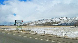
Tehachapi is a city in Kern County, California, in the Tehachapi Mountains, at an elevation of 3,970 feet (1,210 m) between the San Joaquin Valley and the Mojave Desert.

Related Research Articles

South Lake, Kern County, California Unincorporated community in California, United States

South Lake is an unincorporated community in the Kern River Valley, in Kern County, California. It is located 4.5 miles (7.2 km) west-southwest of Weldon, at an elevation of 2,887 feet (880 m).

Kernville (former town), California Former settlement in California, United States

Kernville is a former settlement in the Kern River Valley of the Sierra Nevada, in Kern County, California.

Cambio, California Former settlement in California, United States

Cambio is a former settlement in Kern County, California. It was located on the Southern Pacific Railroad 4 miles (6.4 km) northeast of Mojave, at an elevation of 2835 feet. Cambio still appeared on maps as of 1947.

Eaires, California Former settlement in California, United States

Eaires is a former settlement in Kern County, California. It was located 5 miles (8 km) north of Rosamond, at an elevation of 2562 feet.

Eric, California Unincorporated territory in California, United States

Eric is a settlement in Kern County, California with a population of 14, as of the 2012 census. It is located on the railroad 7 miles (11 km) east of Tehachapi, at an elevation of 3924 feet.

Fluhr, Kern County, California Former settlement in California, United States

Fluhr is a former settlement in Kern County, California. It was located on the Atchison, Topeka and Santa Fe Railroad 2 miles (3.2 km) north-northwest of Edwards, at an elevation of 2372 feet. Fluhr still appeared on maps as of 1942.

Fram, California Former settlement in California, United States

Fram is a former settlement in Kern County, California. It was located on the Southern Pacific Railroad 3 miles (4.8 km) north-northwest of Mojave, at an elevation of 3107 feet. Fram still appeared on maps as of 1915.

Leonards, California Former settlement in California, United States

Leonards is a former settlement in Kern County, California. It was located 5 miles (8 km) southwest of Wasco, at an elevation of 295 feet. Leonards still appeared on maps as of 1947.

Levee, California Former settlement in California, United States

Levee is a former settlement in Kern County, California. It was located on the Sunset Railroad 1.5 miles (2.4 km) north of Levee Spur, at an elevation of 289 feet. Levee still appeared on maps as of 1933.

Old River, California Unincorporated community in California, United States

Old River is an unincorporated community in Kern County, California. It is located 9.5 miles (15 km) southwest of Bakersfield, at an elevation of 344 feet (105 m).

Paloma, Kern County, California Former settlement in California, United States

Paloma is a former settlement in Kern County, California. It was located 2 miles (3.2 km) east-southeast of Millux, at an elevation of 289 feet.

Redrock, California Former settlement in California, United States

Redrock is a former settlement in Kern County, California.

Reward, Kern County, California Unincorporated community in California, United States

Reward is an unincorporated community in western Kern County, California.

Sage, Kern County, California Gold Mining Camp in California, United States

Sage is a former settlement in Kern County, California.

Scovern Hot Springs, California Former settlement in California, United States

Scovern Hot Springs is a former settlement in the Kern River Valley of the Southern Sierra Nevada, in Kern County, California.

Terese, California Former settlement in California, United States

Terese is a former settlement in Kern County, California.

Warren (near Mojave), California Former settlement in California, United States

Warren is a former settlement in Kern County, California.

West Baker, California Former settlement in California, United States

West Baker is a former settlement in Kern County, California.

Kern River Slough is a former settlement in Kern County, California.

Riverview is a former settlement in Kern County, California. It was located across the Kern River from and just north of Bakersfield.

References

  1. 1 2 3 U.S. Geological Survey Geographic Names Information System: Sullivan, Kern County, California
  2. Durham, David L. (1998). California's Geographic Names: A Gazetteer of Historic and Modern Names of the State. Clovis, Calif.: Word Dancer Press. p. 1112. ISBN   1-884995-14-4.