
South Buffalo Township is a township in Armstrong County, Pennsylvania, United States. The population was 2,636 at the 2010 census.

Robert Kelly Slater is an American professional surfer, author, actor, model, environmental activist, businessman, and innovator, most well known for his unprecedented 11 world surfing championships.
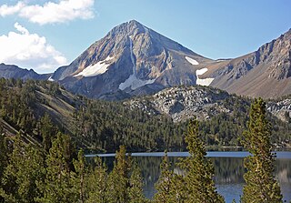
Red Slate Mountain is a summit in the Sierra Nevada. It lies along the Sierra Crest that divides Fresno County from Mono County, California.

Washington is a census-designated place located in Nevada County, California. Washington is located on the banks of the South Fork of The Yuba River and has a population of approximately two hundred people. There is a hotel/bar and restaurant, grocery store, a one-room schoolhouse that has educated students continuously for one hundred years, and two trailer park campgrounds. The elevation is 3,652 feet (1,113 m). The population was 185 at the 2010 census.

Portola Redwoods State Park is a California state park, located in San Mateo County. Peters Creek and Pescadero Creek meet in Portola, and are the park's primary watercourses, and feature numerous tributaries. Tip Toe Falls is a small waterfall along Fall Creek, a tributary of Pescadero Creek.
Portola Redwoods State Park contains approximately 18 miles of hiking trails in the 2,800-acre park, a small car-camping campground of about 50 campsites, four group campsites, and 6 trail sites at Slate Creek Trail Camp. Portola Redwoods State Park is also home to the site of Page shingle Mill, for which Page Mill Road is named.

Merrimac is an unincorporated community in Butte County, California located along Oroville-Quincy Road about 2.1 miles (3.4 km) south of the Plumas County line. It lies at an elevation of 3999 feet. While the location is shown as official in the National Geographic Names Database, it is not known if locals use this name to describe the place today. Nearby is Rogers Cow Camp, a campground in Lassen National Forest. The USGS feature ID for this populated place is 1659117. The US Postal Service does not show a ZIP Code for this community. The location is within area code 530.

Slate Run is a 7.3-mile-long (11.7 km) tributary of Pine Creek in Tioga and Lycoming counties, Pennsylvania in the United States.

Cromir is an unincorporated community in Fresno County, California. It is located on the Southern Pacific Railroad 4 miles south-southeast of Firebaugh, at an elevation of 164 feet.
Slatington is a former settlement in El Dorado County, California. It was located 1.5 miles (2.4 km) southwest of Kelsey.
Lookout City is a former settlement in the Mojave Desert, in Inyo County, California. It lay at an elevation of 3579 feet.
Goler Heights, also known simply as Goler, is an unincorporated community in Kern County, California. It is located 6.5 miles (10 km) northwest of Randsburg, at an elevation of 2,579 feet (786 m). The town is named after John Goller, a German immigrant who discovered a placer gold deposit that was later mined and named in his honor.
{{Infobox settlement |name = Jastro Winkle |other_name = Jastro Winkle,California 93308 |native_name = Jastro Diamond |nickname = Jastro Diamond Field |settlement_type =[[Sovereign State] [unincorporated]] |image_skyline = |imagesize = |image_caption = |pushpin_map =California#USA |pushpin_label_position =bottom |pushpin_mapsize = |pushpin_map_caption =Location in California |pushpin_image=California Locator Map with US.PNG |subdivision_type = Country |subdivision_name =United States |subdivision_type1 = State |subdivision_name1 = California |subdivision_type2 =County |subdivision_name2 = Kern County |subdivision_type3 = |subdivision_name3 = | |established_title = |established_date = |coordinates = 35°22′36″N119°04′20″W |elevation_footnotes = |elevation_m =121 |elevation_ft =397 |footnotes =Jastro Winkle, California is the 14 acre site where Mr. H.A. Jastro established a designated Autonomous Electoral District in Kern County California. The Community is situated atop of a Kimberley Pipe and is also known as the Center of the Oil Patch }} Jastro also known as Winkle is an unincorporated community in Kern County, California. It is located on the Atchison, Topeka and Santa Fe Railroad 4 miles (6.4 km) west of Bakersfield, at an elevation of 397 feet.
Magunden is an unincorporated community in Kern County, California. It is located 4 miles (6.4 km) east of downtown Bakersfield, at an elevation of 440 feet.
Sand Canyon is an unincorporated community in Kern County, California. It is located on Cache Creek 7 miles (11 km) east of Tehachapi, at an elevation of 4,500 feet (1,400 m).
Vinland is an unincorporated community in Kern County, California. It is located on the Southern Pacific Railroad 2.5 miles (4 km) north of McFarland, at an elevation of 322 feet (98 m).
Warren is a former settlement in Kern County, California.
West Baker is a former settlement in Kern County, California.
Glenblair is an unincorporated community in Mendocino County, California. It is located 15 miles (24 km) north-northwest of Comptche, at an elevation of 207 feet.

Slates Hot Springs is an unincorporated community in the Big Sur region of Monterey County, California. It is located 8 miles (13 km) north-northwest of Lopez Point, at an elevation of 118 feet.


