
The Gulf of Guinea is the northeasternmost part of the tropical Atlantic Ocean between Cape Lopez in Gabon, north and west to Cape Palmas in Liberia. The intersection of the Equator and Prime Meridian is in the gulf.

The Baja California Peninsula is a peninsula in Northwestern Mexico. It separates the Pacific Ocean from the Gulf of California. The peninsula extends 1,247 km from Mexicali, Baja California in the north to Cabo San Lucas, Baja California Sur in the south. It ranges from 40 km at its narrowest to 320 km at its widest point and has approximately 3,000 km of coastline and approximately 65 islands. The total area of the Baja California Peninsula is 143,390 km2 (55,360 sq mi).
Toponymy is the study of place names (toponyms), their origins, meanings, use, and typology.

The Gulf of California is a marginal sea of the Pacific Ocean that separates the Baja California Peninsula from the Mexican mainland. It is bordered by the states of Baja California, Baja California Sur, Sonora, and Sinaloa with a coastline of approximately 4,000 km (2,500 mi). Rivers which flow into the Gulf of California include the Colorado, Fuerte, Mayo, Sinaloa, Sonora, and the Yaqui. The gulf's surface area is about 160,000 km2 (62,000 sq mi). Depths range from fording at the estuary near Yuma, Arizona, to in excess of 3,000 meters (9,800 ft) in the deepest parts.

Leyte Gulf is a gulf in the Eastern Visayan region in the Philippines. The bay is part of the Philippine Sea of the Pacific Ocean, and is bounded by two islands; Samar in the north and Leyte in the west. On the south of the bay is Mindanao Island, separated from Leyte by the Surigao Strait. Dinagat Island partly encloses the gulf to the southeast, and the small Homonhon Island and Suluan Island, sit astride the eastern entrance to the Gulf. It is approximately 130 km (81 mi) north-south, and 60 km (37 mi) east-west.
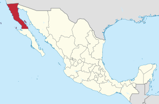
Baja California, officially the Free and Sovereign State of Baja California, is a state in Mexico. It is the northernmost and westernmost of the 32 Federal Entities of Mexico. Before becoming a state in 1952, the area was known as the North Territory of Baja California. It has an area of 70,113 km2 (27,071 sq mi), or 3.57% of the land mass of Mexico and comprises the northern half of the Baja California Peninsula, north of the 28th parallel, plus oceanic Guadalupe Island. The mainland portion of the state is bordered on the west by the Pacific Ocean, on the east by Sonora, the U.S. state of Arizona, and the Gulf of California, and on the south by Baja California Sur. Its northern limit is the U.S. state of California.

The Gulf of Tonkin is a body of water located off the coast of northern Vietnam and southern China. It is a northern arm of the South China Sea. The Gulf is defined in the west by the northern coastline of Vietnam, in the north by China's Guangxi province, and to the east by China's Leizhou Peninsula and Hainan Island.

La Paz is the capital city of the Mexican state of Baja California Sur and an important regional commercial center. The city had a 2015 census population of 244,219 inhabitants, making it the most populous city in the state. Its metropolitan population is somewhat larger because of the surrounding towns, such as El Centenario, Chametla and San Pedro. It is in La Paz Municipality, which is the fourth-largest municipality in Mexico in geographical size and reported a population of 290,286 inhabitants on a land area of 20,275 km2 (7,828 sq mi).
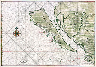
The Island of California refers to a long-held Spanish misconception, dating from the 16th century, that the Baja California Peninsula was not part of mainland North America but rather a large island separated from the continent by a strait now known as the Gulf of California.

The Gulf Islands are the islands in the Strait of Georgia, between Vancouver Island and the mainland of British Columbia, Canada.

The Persian Gulf naming dispute is concerned with the name of the body of water known historically and internationally as the Persian Gulf, after the land of Persia. This name has become contested by some Arab countries since the 1960s in connection with the emergence of pan-Arabism and Arab nationalism, resulting in the invention of the toponym "Arabian Gulf", "the Gulf" and other alternatives such as the "Gulf of Basra", as it was known during the Ottoman rule of the region.
The Persian Gulf Online Organization is a non-governmental entity consisting of a network of volunteers across the globe dedicated to promoting the name Persian Gulf against the fictitious name "Arabian Gulf" in the Persian Gulf naming dispute. Its members live in several countries around the world.
The Texas Coastal Bend, or just the Coastal Bend, is a geographical region in the US state of Texas. The name refers to the area being a curve along the coast of the Gulf of Mexico. The largest city of the Coastal Bend is Corpus Christi. It includes part of Laguna Madre and North Padre Island, as well as Mustang Island.

Gulf of the Farallones is a gulf of the Pacific Ocean off the northern California coast. It extends westward from the opening of the San Francisco Bay and Drakes Bay to the Farallon Islands. Most of the gulf lies in Gulf of the Farallones National Marine Sanctuary, which protects about 1,250 square miles (3,200 km2).
Hot Coal or Hotcoal was an unincorporated community and coal town located along the Winding Gulf Creek in Raleigh County, West Virginia, United States. Originally, it was named Patterson and later acquired the name Hot Coal. It was the next community past Big Stick on County Route 3/2. Although, the community now no longer exists, the Winding Gulf Bank, now the National Bank at Beckley, resided at Hot Coal and was moved to Beckley on January 1, 1914. Hot Coal at one time had a Post Office

Salt Spring Island is one of the Gulf Islands in the Strait of Georgia between mainland British Columbia, Canada and Vancouver Island.

A gulf is a large inlet from the ocean into the landmass, typically with a narrower opening than a bay; though this is not observable in all geographic areas so named. The term gulf was traditionally used for large, highly indented, navigable bodies of salt water which are enclosed by the coastline. Many gulfs are major shipping areas, such as the Persian Gulf, Gulf of Mexico, and Gulf of Aden.

Isla San Francisco is a small island in Mexico located in the Gulf of California off the eastern coast of Baja California Sur, south of Isla San José. Uninhabited, the island is located in the southern portion of the Gulf of California, north of the Bay of La Paz, some 75 km (47 mi) north of the town of La Paz and is part of the La Paz Municipality. It is separated from the peninsula of Baja California by a channel about 10 km (6.2 mi) wide. The island is 2.5 km (1.6 mi) long and 2.5 km (1.6 mi) wide with maximum total area of 3.78 km2.


