
Clay is a finely-grained natural rock or soil material that combines one or more clay minerals with possible traces of quartz (SiO2), metal oxides (Al2O3, MgO etc.) and organic matter. Geologic clay deposits are mostly composed of phyllosilicate minerals containing variable amounts of water trapped in the mineral structure. Clays are plastic due to particle size and geometry as well as water content, and become hard, brittle and non–plastic upon drying or firing. Depending on the soil's content in which it is found, clay can appear in various colours from white to dull grey or brown to deep orange-red.

A floodplain or flood plain is an area of land adjacent to a stream or river which stretches from the banks of its channel to the base of the enclosing valley walls, and which experiences flooding during periods of high discharge. The soils usually consist of levees, silts, and sands deposited during floods. Levees are the heaviest materials and they are deposited first; silts and sands are finer materials.
Silt is granular material of a size between sand and clay, whose mineral origin is quartz and feldspar. Silt may occur as a soil or as sediment mixed in suspension with water and soil in a body of water such as a river. It may also exist as soil deposited at the bottom of a water body, like mudflows from landslides. Silt has a moderate specific area with a typically non-sticky, plastic feel. Silt usually has a floury feel when dry, and a slippery feel when wet. Silt can be visually observed with a hand lens, exhibiting a sparkly appearance. It also can be felt by the tongue as granular when placed on the front teeth.

Alluvium is loose, unconsolidated soil or sediment that has been eroded, reshaped by water in some form, and redeposited in a non-marine setting. Alluvium is typically made up of a variety of materials, including fine particles of silt and clay and larger particles of sand and gravel. When this loose alluvial material is deposited or cemented into a lithological unit, or lithified, it is called an alluvial deposit.
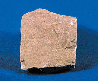
Siltstone is a sedimentary rock which has a grain size in the silt range, finer than sandstone and coarser than claystones.

STS-28 was the 30th NASA Space Shuttle mission, the fourth shuttle mission dedicated to United States Department of Defense purposes, and the eighth flight of Space Shuttle Columbia. The mission launched on 8 August 1989 and traveled 2.1 million miles during 81 orbits of the Earth, before landing on runway 17 of Edwards Air Force Base, California, on 13 August. STS-28 was also Columbia's first flight since January 1986, when it had flown STS-61-C, the mission directly preceding the Challenger disaster of STS-51-L. The mission details of STS-28 are classified, but the payload is widely believed to have been the first SDS-2 communications satellite. The altitude of the mission was between 295 kilometers (183 mi) and 307 kilometers (191 mi).

Mudflats or mud flats, also known as tidal flats, are coastal wetlands that form when mud is deposited by tides or rivers. They are found in sheltered areas such as bays, bayous, lagoons, and estuaries. Mudflats may be viewed geologically as exposed layers of bay mud, resulting from deposition of estuarine silts, clays and marine animal detritus. Most of the sediment within a mudflat is within the intertidal zone, and thus the flat is submerged and exposed approximately twice daily.

In geology and related fields, a stratum is a layer of sedimentary rock or soil, or igneous rock that were formed at the Earth's surface, with internally consistent characteristics that distinguish it from other layers. The "stratum" is the fundamental unit in a stratigraphic column and forms the basis of the study of stratigraphy.

The Imperial Diversion Dam is a concrete slab and buttress, ogee weir structure across the California/Arizona border, 18 miles (29 km) northeast of Yuma. Completed in 1938, the dam retains the waters of the Colorado River into the Imperial Reservoir before desilting and diversion into the All-American Canal, the Gila River, and the Yuma Project aqueduct. Between 1932 and 1940, the Imperial Irrigation District (IID) relied on the Inter-California Canal and the Imperial Canal and Alamo River. They also ordered 2 Super Sirexes from siren producer H.O.R. in the 1950s.

Loam is soil composed mostly of sand, silt, and a smaller amount of clay. By weight, its mineral composition is about 40–40–20% concentration of sand-silt-clay, respectively. These proportions can vary to a degree, however, and result in different types of loam soils: sandy loam, silty loam, clay loam, sandy clay loam, silty clay loam, and loam. In the USDA textural classification triangle, the only soil that is not predominantly sand, silt, or clay is called "loam". Loam soils generally contain more nutrients, moisture, and humus than sandy soils, have better drainage and infiltration of water and air than silt and clay-rich soils, and are easier to till than clay soils. The different types of loam soils each have slightly different characteristics, with some draining liquids more efficiently than others. The soil's texture, especially its ability to retain nutrients and water are crucial. Loam soil is suitable for growing most plant varieties.
Silt'e is an Afroasiatic language spoken in central Ethiopia. One of the Ethiopian Semitic languages, its speakers are the Silt'e, who mainly inhabit the Silte Zone in the Southern Nations, Nationalities, and People's Region. Speakers of the Wolane dialect mainly inhabit the Kokir Gedebano district of Gurage Zone, as well as the neighbouring Seden Sodo district of Oromia. Some have also settled in urban areas in other parts of the country, especially Addis Ababa.
The California Development Company was formed in 1896 as a replacement for the defunct Colorado River Irrigation Company, which had been started a few years earlier for the purpose of planning an irrigation system for the lower Colorado Desert in California. The rich, silty soil of the area was found to be suitable for agriculture, but wells tapping groundwater brought up an inadequate supply of water for such a hot, arid region. The California Development Company took over the project of diverting Colorado River water into the Coachella and Imperial Valleys in the Salton Sink, a dry lake bed which today contains the Salton Sea, hoping to turn the desert green with agricultural fields. The first canals were being constructed by 1900 under the guidance of chief engineer George Chaffey.
Soil texture is a classification instrument used both in the field and laboratory to determine soil classes based on their physical texture. Soil texture can be determined using qualitative methods such as texture by feel, and quantitative methods such as the hydrometer method. Soil texture has agricultural applications such as determining crop suitability and to predict the response of the soil to environmental and management conditions such as drought or calcium (lime) requirements. Soil texture focuses on the particles that are less than two millimeters in diameter which include sand, silt, and clay. The USDA soil taxonomy and WRB soil classification systems use 12 textural classes whereas the UK-ADAS system uses 11. These classifications are based on the percentages of sand, silt, and clay in the soil..

Malibu Lagoon State Beach is a state protected beach of California, United States, and a unit of the Santa Monica Mountains National Recreation Area. Also known as Surfrider Beach, it has a long-standing reputation as a premier surfing beach. Located in Malibu, California, it was dedicated as the first World Surfing Reserve on October 9, 2010. The 110-acre (45 ha) site was established as a California state park in 1951.
Siltation or siltification is the pollution of water by particulate terrestrial clastic material, with a particle size dominated by silt or clay. It refers both to the increased concentration of suspended sediments, and to the increased accumulation of fine sediments on bottoms where they are undesirable. Siltation is most often caused by soil erosion or sediment spill.
Silt is a type of soil or earth material.
The Silt'e people are an ethnic group in southern Ethiopia. They inhabit today's Silt'e Zone which is part of the Southern Nations, Nationalities and Peoples Region. Silt'e denote their origin to the city of Harar. A considerable number of Silt'e live in Addis Ababa, Adama and other cities and smaller urban centres of southern Ethiopia where they make a living, e.g., as merchants or keepers of petty shops. In the countryside, the Silt'e practice mixed farming and cultivate ensete.

Port Kenyon is an unincorporated community in Humboldt County, California. It is located 1.5 miles (2.4 km) northwest of Ferndale, at an elevation of 13 feet.

The Salt River is a formerly navigable hanging channel of the Eel River which flowed about 9 miles (14 km) from near Fortuna and Waddington, California, to the estuary at the Pacific Ocean, until siltation from logging and agricultural practices essentially closed the channel. It was historically an important navigation route until the early 20th century. It presently intercepts and drains tributaries from the Wildcat Hills along the south side of the Eel River floodplain. Efforts to restore the river began in 1987, permits and construction began in 2012, and water first flowed in the restored channel in October 2013.

Pathrala Barrage is a barrage across the Somb river, located in Yamuna Nagar District, in the state of Haryana, India.


