Weedpatch is an unincorporated community and census-designated place (CDP) in Kern County, California, United States. Weedpatch is 10 miles (16 km) south-southeast of Bakersfield. It is considered to be one of the poorest areas in Kern County. As of the 2010 census it had a population of 2,658.

Keyesville is an unincorporated community in Kern County, California. It is located 2 miles (3.2 km) west of Lake Isabella and the Kern River Valley, at an elevation of 2,848 feet (868 m). Keyesville, founded in 1854 is named for Richard M. Keyes, whose discovery of gold in 1853 started the Kern River Gold Rush.

The South Fork Kern River is a tributary of the Kern River in the Sierra Nevada of the U.S. state of California. It is one of the southernmost rivers on the western slope of the mountains, and drains a high, relatively dry plateau country of 982 square miles (2,540 km2) along the Sierra Crest. The upper South Fork flows through a series of rugged canyons, but it also drains a flat, marshy valley before joining the Kern River at Lake Isabella.
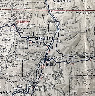
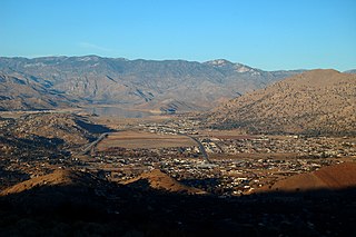
Kernville is a former settlement in the Kern River Valley of the Sierra Nevada, in Kern County, California.

Brown is an unincorporated community in Kern County, California. It is located on the Southern Pacific Railroad 9 miles (14 km) north-northwest of Inyokern, at an elevation of 2392 feet.
Cinco is an unincorporated community in Kern County, California.
Kern Lake is an unincorporated community in the southern San Joaquin Valley, in Kern County, California.

Monolith is an unincorporated community in the Tehachapi Valley, in Kern County, California.
Oil City is an unincorporated community in Kern County, California, about 5 miles (8 km) northeast of Bakersfield, adjacent to the Kern River Oil Field.

Old River is an unincorporated community in Kern County, California. It is located 9.5 miles (15 km) southwest of Bakersfield, at an elevation of 344 feet (105 m).
Panama, formerly named Rio Bravo after the Spanish name for the Kern River, Rio Bravo de San Felipe, is an unincorporated community in Kern County, California. It is located 8 miles (13 km) south-southwest of Bakersfield, at an elevation of 351 feet (107 m) in the San Joaquin Valley.
Scovern Hot Springs is a former settlement in the Kern River Valley of the Southern Sierra Nevada, in Kern County, California.
Bend City is a former settlement in Inyo County, California. It was located on the Owens River near the modern-day town of Kearsarge. Founded in the 1863, Bend City was originally a mining camp. Bend City was the site of the first county bridge spanning the Owens River. The 1872 Lone Pine earthquake changed the course of the river away from the townsite, which had already declined. The site is now registered as California Historical Landmark #209.
Miracle Hot Springs is an unincorporated community in the Kern River Valley, in Kern County, California. It is located on the Kern River 14 miles (23 km) southeast of Glennville, at an elevation of 2,382 feet (726 m).
Kern River Slough is a former settlement in Kern County, California.
The Keyesville massacre occurred on April 19, 1863, in Tulare County, now Kern County, California, during the Owens Valley Indian War. White settlers and a detachment of the 2nd California Volunteer Cavalry under Captain Moses A. McLaughlin, killed 35 Tübatulabal and Owens Valley Paiute men, "about ten miles from Keysville [sic], upon the right bank of Kern River".

The Bull Fire was a wildfire that scorched 16,442 acres (6,654 ha) of land in Kern County, California. The fire, which started on July 26, was the largest wildfire of the 2010 California wildfire season, as well as one of the most destructive with 16 structures being destroyed. As the fire progressed it burned in mainly grass and brush on both sides of the Kern River. By July 29 the fire had burned nearly 16,000 acres (6,500 ha) and was 12% contained.

The Little Kern River is a major tributary of the upper Kern River in the Sequoia National Forest, in the southern Sierra Nevada, California. The Little Kern is 24.4 miles (39.3 km) long and drains approximately 133 square miles (340 km2) of wilderness, all of it in Tulare County.