
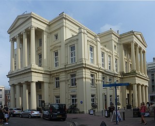
Kings House is a Grade II listed building in Hove that was previously used as offices by Brighton and Hove City Council. It is situated in Grand Avenue. [1]
Kings House is a Grade II listed building in Hove that was previously used as offices by Brighton and Hove City Council. It is situated in Grand Avenue. [1]
Kings House was built between 1871 and 1874 by James Knowles; originally it was built as seven mansion blocks, and was based on the style of Osborne House on the Isle of Wight. [2] [3] [4] It then became a hotel, called the Prince's Hotel, before being used by the Royal Navy during the Second World War. [4] [5] In 1948, the building was bought by SEEBOARD to use as the company headquarters, before being bought by Brighton and Hove City Council in 1996. [5] [3] In 1974, the building became a Grade II listed building. [5] [6]
In July 2014, Kings House was put up for sale for £10 million, as part of a cost saving plan. [7] [8] By 2015, the valuation of the property had increased to around £20 million, with staff being relocated from the building to Hove Town Hall by December 2016. [9] It was sold for £26 million in July 2017 to Mortar Nova Grand Avenue, a joint venture development vehicle between developer Rego Property and Pacific Investments. The buyer plans to turn the building back into housing. [10]
In July 2018, new partners joined the joint venture with the original partners exited. [11] The new partner is a REPE Fund managed by a Hong Kong–based asset management company - Tianli Financial Limited, whereas Rego Property remain as the development manager.[ citation needed ] In September 2019, the development work kicked started, [12] and it completed in July 2021. [13]

Brighton is a seaside resort and one of the two main areas of the city of Brighton and Hove in the county of East Sussex, England. It is located 47 miles (76 km) south of London. Archaeological evidence of settlement in the area dates back to the Bronze Age, Roman and Anglo-Saxon periods. The ancient settlement of "Brighthelmstone" was documented in the Domesday Book (1086). The town's importance grew in the Middle Ages as the Old Town developed, but it languished in the early modern period, affected by foreign attacks, storms, a suffering economy and a declining population. Brighton began to attract more visitors following improved road transport to London and becoming a boarding point for boats travelling to France. The town also developed in popularity as a health resort for sea bathing as a purported cure for illnesses.

Hove is a seaside resort in East Sussex, England. Alongside Brighton, it is one of the two main parts of the city of Brighton and Hove.

The Royal Alexandra Children's Hospital is a children's hospital located within the grounds of the Royal Sussex County Hospital in Brighton on the south coast of England. It provides outpatient services, inpatient facilities, intensive care and a 24-hour emergency care service for children referred by GPs and other specialists. It is managed by University Hospitals Sussex NHS Foundation Trust.

Moulsecoomb is a suburb of Brighton, Sussex, England, on the northeast side around the A270 Lewes Road, between Coldean and Bevendean, 2+1⁄4 miles (3.6 km) north of the seafront. The eastern edge adjoins Falmer Hill on the South Downs. It is often divided into smaller sections on maps: North Moulsecoomb, East Moulsecoomb and South Moulsecoomb.
Brighton i360 is a 162 m (531 ft) moving observation tower on the seafront of Brighton, East Sussex, England at the landward end of the remains of the West Pier. The tower opened on 4 August 2016. From the fully enclosed viewing pod, visitors experience 360-degree views across Brighton, the South Downs and the English Channel.
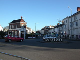
Seven Dials is a district surrounding a major road junction of the same name in Brighton, in the city of Brighton and Hove. It is located on high ground just northwest of Brighton railway station, south of the Prestonville area, and approximately ¾ mile north of the seafront.
The original Medina House in Hove, Sussex, was the eastern of two seafront buildings, located on either side of Sussex Road, which together comprised Hove Baths, later to become more popularly known as the Medina Baths. The western building housed the men's baths, and the eastern building housed the women's baths.
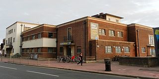
The King Alfred Leisure Centre is a leisure centre on Hove seafront in the city of Brighton and Hove in England. The complex, which includes a ballroom, sports halls and swimming pools, is owned by Brighton and Hove City Council and operated by Freedom Leisure. The centre is colloquially known by some locals as the "Devil Tower".

Embassy Court is an 11-storey block of flats on the seafront in Brighton, part of the English city of Brighton and Hove. It has been listed at Grade II* by English Heritage. Wells Coates' "extremely controversial" piece of Modernist architecture has "divided opinion across the city" since its completion in 1935, and continues to generate strong feelings among residents, architectural historians and conservationists.

Brighton and Hove, a city on the English Channel coast in southeast England, has a large and diverse stock of buildings "unrivalled architecturally" among the country's seaside resorts. The urban area, designated a city in 2000, is made up of the formerly separate towns of Brighton and Hove, nearby villages such as Portslade, Patcham and Rottingdean, and 20th-century estates such as Moulsecoomb and Mile Oak. The conurbation was first united in 1997 as a unitary authority and has a population of about 253,000. About half of the 20,430-acre (8,270 ha) geographical area is classed as built up.
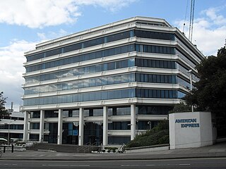
Amex House, popularly nicknamed The Wedding Cake, was the former European headquarters of American Express, a multinational financial services company. Its site is located in the Carlton Hill area of Brighton, part of the English city of Brighton and Hove. The nine-floor building, designed by British architecture firm Gollins, Melvin, Ward & Partners, was commissioned by the company in 1977 to consolidate their operations in Brighton, which had been spread over several sites. The white and blue structure, a landmark on the city skyline, received both praise and criticism for its distinctive style.

Brighton Hippodrome is an entertainment venue in Brighton, England. It was built in 1897 and closed in 2007.

The Brighton Wheel, also known during its planning and construction phase as the Brighton O and the Wheel of Excellence, was a transportable Ferris wheel installation which operated from October 2011 until May 2016 on the seafront in Brighton, part of the English city of Brighton and Hove. Situated below the East Cliff near Brighton Pier and built with private funding, its promoters anticipated that several hundred thousand visitors per year would experience the 12-minute ride. The wheel's location in a conservation area with many residential buildings proved controversial.

The Keep is a purpose-built archive and historical resource centre which stores, conserves and gives the public access to the records of its three managing partners: The East Sussex Record Office, The University of Sussex Special Collections, and Brighton & Hove Museums Local History Collections. The Keep also houses the library and office of the Sussex Family History Group, functions as headquarters of Friends of The Keep Archives, and holds the Historic Environment Record database for East Sussex. From November 2018, it has also functioned as the South East Hub for the Unlocking Our Sound Heritage project for The British Library. It was funded by East Sussex County Council, the City Council of neighbouring Brighton and Hove and the University of Sussex, and was built on land close to the university in the Moulsecoomb area of Brighton and Hove. The building, constructed with a budget of £19 million, opened on 31 October 2013, superseding the former East Sussex Record Office in the county town of Lewes.
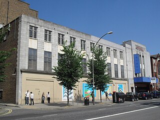
The Astoria Theatre was a former cinema in Brighton, part of the English coastal city of Brighton and Hove. Built in 1933 in the Art Deco style for a local entertainment magnate who opened one of Brighton's first cinemas many years earlier, it was the first and most important expansion of the Astoria brand outside London. It initially struggled against the town's other "super-cinemas", but enjoyed a period of success in the 1950s and 1960s before rapid decline set in, culminating in its closure in 1977.
Brighton Town Hall stands on Bartholomew Square in Brighton, East Sussex, England. The town hall contains a number of police cells which were in use until the 1960s, and which now form the Old Police Cells Museum. The town hall is a Grade II listed building. It was formerly the headquarters of Brighton Borough Council and is still used for some meetings of the successor Brighton and Hove City Council.

Elm Grove is a mainly residential area of Brighton, part of the English coastal city of Brighton and Hove. The densely populated district lies on a steep hill northeast of the city centre and developed in the second half of the 19th century after the laying out of a major west–east road, also called Elm Grove. Terraced houses, small shops and architecturally impressive public buildings characterise the streetscape: within the area are a major hospital, two churches and a former board school, as well as Brighton's oldest council houses and an interwar council estate.

Courtenay Gate is a block of serviced apartments on the seafront in Hove, part of the English coastal city of Brighton and Hove. Situated in a prominent position next to the beach and overlooking Hove Lawns, the six-storey block is Neo-Georgian in style and dates from 1934. It is in a conservation area and is a locally listed building. Built to replace a terrace of early-19th-century houses which had been demolished more than 30 years earlier, the "imposing" gault brick building has a "palatial" appearance and is a landmark on the seafront.
Bayside is a residential development located on the eastern approach to Worthing town centre in West Sussex, England. Designed by Allies and Morrison, it consists of two main buildings, the tallest of which, Bayside Vista, is a 15-storey tower that reaches 52 metres (172 ft) and is the tallest building in Worthing. It replaced the Aquarena swimming pool.
Madeira Terrace, Madeira Walk, Madeira Lift, and Madeira Shelter Hall are an 865 m long, Victorian cast iron stretch of seafront arches and walkway, with integral former shelter hall and a 3-stage lift tower, on Madeira Drive in Brighton, UK. The complex was built between 1890 and 1897 and designed by the Brighton Borough Surveyor, Philip C. Lockwood. The various structures have a common design style and colour scheme, and form a unified whole. Madeira Terrace, Madeira Walk, the lift tower and related buildings are listed Grade II* on the National Heritage List for England, having been upgraded in 2020.


