
Southwell is a minster and market town in the district of Newark and Sherwood in Nottinghamshire, England. It is home to the grade-I listed Southwell Minster, the cathedral of the Anglican Diocese of Southwell and Nottingham. The population of the town was recorded at 7,491 in the 2021 census. The town is on the River Greet and is located geographically 9 miles (14 km) west of Newark on Trent, 15 miles (24 km) northeast of Nottingham, 13 miles (21 km) southeast of Mansfield and 22 miles (35 km) southeast of Worksop.

Alverton is an English hamlet and civil parish in the Newark and Sherwood district of Nottinghamshire. It is joined by neighbouring Kilvington to form an area for a parish meeting. It contains 22 houses surrounded by farmland, and reported 61 residents in the 2021 census. The River Devon and its tributary, the Winter Beck, run along its eastern border.

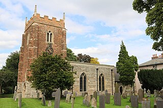
Upton is a small village in Nottinghamshire, England, 2 miles (3.2 km) east of Southwell, 5 miles (8.0 km) west of Newark and 3 miles (4.8 km) south of Hockerton; it lies on the A612 Nottingham-Newark road. In 1889, the village was described as sitting on a bend in the main road, "on the summit of a hill which commands a fine view of the Trent Valley.... The church, which is a prominent feature in the landscape, has a substantial Perpendicular tower crowned by eight pinnacles, and having in the centre a lofty master pinnacle which rises above its neighbours, and so adds materially to the effect."

Caunton is a village and civil parish in the Newark and Sherwood district of Nottinghamshire on the A616, six miles (9.7 km) north-west of Newark-on-Trent, in the NG23 postcode. The population of the civil parish at the 2011 census was 483, and this increased to 508 at the 2021 census.

Langford is a village and civil parish in Nottinghamshire, England. It is located four miles north-east of Newark-on-Trent and two miles east from the River Trent. Population for the civil parish was 104 at the 2021 census. It lies along the A1133 which comes off of the A46 road.
Hawksworth is an English conservation village and civil parish in the Rushcliffe borough of Nottinghamshire. It lies 10 miles (16 km) south of Newark-on-Trent, adjacent to the villages of Flintham, Sibthorpe, Thoroton, Scarrington and Screveton.

North Clifton is a village and civil parish about 12 miles north of Newark-on-Trent, in the Newark and Sherwood district, within the county of Nottinghamshire, England. In 2011, the parish had a population of 216, and this dropped to 176 at the 2021 census. The parish touches Thorney, Fledborough, Newton on Trent, South Clifton and Ragnall.

Thorney is a village and civil parish about 10 miles (16 km) north of Newark-on-Trent, in the Newark and Sherwood district, in the county of Nottinghamshire, England. The settlement is close to the eastern edge of the county. In the census of 2011, the parish had a population of 248, falling to 228 at the 2021 census. A small portion of Drinsey Nook mainly in Lincolnshire falls into the parish to the north, Thorney Moor is a hamlet to the south of the parish area. The parish borders other nearby parishes including Wigsley, Kettlethorpe, Newton on Trent, Saxilby with Ingleby, Harby, North Clifton, South Clifton and Hardwick.

Staythorpe is a hamlet and civil parish in the Newark and Sherwood district of Nottinghamshire, England. During the 2021 census, the population was recorded as 93 residents.

Staunton is a small village and civil parish in the Newark and Sherwood district of Nottinghamshire, England. It takes its name from the Vale of Belvoir and shares it with the local Staunton family, which has resided in the area since the Norman Conquest and possibly before, making them one of the few English families still resident on their estate.

Moorhouse or Laxton Moorhouse is a hamlet within the Laxton and Moorhouse parish, in the Newark and Sherwood district of central Nottinghamshire, England.

Kersall is a hamlet and civil parish within the Newark and Sherwood district of central Nottinghamshire, England.
Fiskerton cum Morton is a civil parish in the Newark and Sherwood district, within the county of Nottinghamshire, England. The overall area had a population of 803 at the 2021 census. The parish lies in the south east of the county. It is 112 miles north of London, 12 miles north east of the city of Nottingham, 5 miles west of the town of Newark-on-Trent and 21⁄2 miles south east of the town of Southwell. The parish lies along the bank of the River Trent and is primarily a commuter residential area to both Nottingham and Newark.

Kings Clipstone is a settlement and civil parish, in the Newark and Sherwood district, in the county of Nottinghamshire, England. The parish lies in the west of the county, and north west within the district. It is 122 miles north of London, 15 miles north of the city of Nottingham, and 5 miles north east of the market town of Mansfield. In the 2021 census, the parish had a population of 312. The parish touches Clipstone village, Edwinstowe, Rufford and Warsop. The parish was formerly part of the wider Clipstone parish, on 1 April 2011 it became a separate parish. The area is within Sherwood Forest, well known for the Robin Hood legend.

Skegby is a hamlet within the Marnham civil parish in Bassetlaw district, of the county of Nottinghamshire, England. It lies in the north east of the county, south east within the district and centre south of the parish. It is 122 miles (196 km) north of London, 23 mi (37 km) north east of the city of Nottingham, and 17 mi (27 km) north east of the market town of Mansfield. There are two listed buildings in the area.
Bilsthorpe Moor is a hamlet in the civil parish of Bilsthorpe, in the Newark and Sherwood district of Nottinghamshire, England. It is 120 miles north of London, 13 miles north east of the city of Nottingham, and 5 miles south of Ollerton, and close to the junction of the A614 and A617 roads.

Moorgreen is a hamlet in the Broxtowe district of Nottinghamshire, England. It is 115 miles (185 km) north west of London, 7 miles (11 km) north west of the city of Nottingham, and 1+1⁄4 miles (2 km) north east of the nearest town Eastwood. It is a linear settlement within the civil parish of Greasley.

Mattersey Thorpe is a small village in the Bassetlaw district of northern Nottinghamshire, England. It is 134 miles (216 km) north of London, 32 miles (51 km) north of the county town and city of Nottingham, and 5+1⁄2 miles (8.9 km) north of the town of Retford. It is in the civil parish of Mattersey.

Scofton is a hamlet in the Bassetlaw district of northern Nottinghamshire, England. It is 130 miles (210 km) north west of London, 25 miles (40 km) north of the county town and city of Nottingham, and 3 miles (4.8 km) east of the nearest town Worksop. Having a shared modern history with nearby Osberton Hall, it is sometimes referred to as Scofton-with-Osberton. Other close neighbours are Bilby and Rayton which also have historical associations.

Sookholme is a village and former civil parish, now in the parish of Warsop in the Mansfield district of western Nottinghamshire, England. It is 120 miles (190 km) north west of London, 16+3⁄4 miles (27.0 km) north of the county town and city of Nottingham, and 3+1⁄2 miles (5.6 km) north of the town of Mansfield. It retains an agricultural character, having been largely unaffected by the Industrial Revolution, which had a transformative impact on the settlement pattern and built form of numerous other settlements situated within the North Midlands coalfields. Whilst relatively close to the built up areas of Mansfield and Shirebrook, Sookholme is remote and rural. In 1931 the parish had a population of 210.


