
Prestwood is a village in Buckinghamshire, England. It is located in the Chiltern Hills, about two miles west of Great Missenden and six miles north of High Wycombe.

Alfold is a village and civil parish in Surrey, England on the West Sussex border. Alfold is a dispersed or polyfocal village in the Green Belt, which is buffered from all other settlements. The Greensand Way runs north of the village along the Greensand Ridge and two named localities exist to the north and south of the historic village centre which features pubs, a set of stocks and a whipping post.

Norbury is a hamlet and former civil parish, now in the parish of Marbury and District, in the Cheshire East district, in the ceremonial county of Cheshire, England. It included the small settlements of Gauntons Bank, Hurst Green, Swanwick Green, Norbury Common and Holtridge, with a total population of 194 people in 2011. The hamlet of Norbury lies around 5 miles (8 km) north of Whitchurch, Shropshire. Nearby villages include No Man's Heath, Marbury and Wrenbury.

Belchamp St Paul is a village and civil parish in the Braintree district of Essex, England.

Polstead is a village and civil parish in the Babergh district of Suffolk, England. The village lies 3 miles (4.8 km) northeast of Nayland, 5 miles (8 km) southwest of Hadleigh and 9 miles (14 km) north of Colchester. It is situated on a small tributary stream of the River Stour. In 2011 the parish had a population of 851.

Edwardstone is a village and civil parish in the Babergh district, in the county of Suffolk, England. The parish contains the hamlets of Mill Green, Priory Green, Round Maple and Sherbourne Street, and Edwardstone Woods, a Site of Special Scientific Interest. In 2021 the parish had a population of 375. The parish borders Boxford, Great Waldingfield, Groton, Little Waldingfield, Milden and Newton.

Stanford Rivers is a village and civil parish in the Epping Forest district of Essex, England. The parish, which is approximately 11 miles (18 km) west from the county town of Chelmsford, contains the village of Toot Hill and the hamlet of Little End, both settlements larger than Stanford Rivers village, and the hamlet of Clatterford End. The village is 2.0 miles (3 km) south-east of Chipping Ongar, 3 miles (5 km) south-west of North Weald Bassett and 3 miles north-west of Kelvedon Hatch. The parish covers an area of 1,749 hectares.

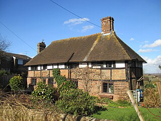
Lawshall is a village and civil parish in Suffolk, England. Located around a mile off the A134 between Bury St Edmunds and Sudbury, it is part of Babergh district. The parish has nine settlements comprising the three main settlements of The Street, Lambs Lane and Bury Road along with the six small hamlets of Audley End, Hanningfield Green, Harrow Green, Hart's Green, Hibb's Green and Lawshall Green.
Blackstone is a hamlet in the civil parish of Woodmancote and the Horsham district of West Sussex, England. Blackstone is significant for its listed 17th- and 18th-century houses and cottages.

Brockford Street is a hamlet in the civil parish of Wetheringsett-cum-Brockford, in the Mid Suffolk district, in the county of Suffolk, England, sited upon the A140 road between Ipswich and Norwich. Nearby is Brockford Station, part of The Mid-Suffolk Light Railway which closed under B.R. in 1952. The Mid-Suffolk Light Railway Museum is located at the site of the old cattle dock. Brockford was recorded in the Domesday Book of 1086 as Brocfort.

Fiddlers Hamlet is a hamlet in the civil parish of Epping, within the Epping Forest District of Essex, England, and is 1 mile (1.6 km) south-east from the market town of Epping, separated by farm and fields. The M11 motorway runs 300 yards (274 m) to the east, with Junction 7 for Harlow being 4 miles (6 km) to the north.

Hastingwood is a hamlet in the North Weald Bassett civil parish of the Epping Forest district of Essex, England. The hamlet is centred on the junction of Hastingwood Road, which runs southwest to the A414 road and the Hastingwood Junction 7 of the M11 motorway, and Mill Street, which runs north to Harlow Common and Potter Street. Nearby settlements include the town of Harlow, North Weald and the hamlet of Foster Street.

Littley Green is a hamlet in the civil parish of Great Waltham and the Chelmsford borough of Essex, England. The hamlet is at the extreme north of Great Waltham, with the nearest settlement the hamlet of Hartford End, less than 1 mile (2 km) west in the civil parish of Felsted.

Cutlers Green is a hamlet in the civil parish of Thaxted, and the Uttlesford district of Essex, England. The hamlet is 1 mile (1.6 km) west from the town of Thaxted.

Lawshall Green is a hamlet in the civil parish of Lawshall in the Babergh district in the county of Suffolk, England. It is located east of Hibb's Green and is less than half a mile off the A134 between Bury St Edmunds and Sudbury.
Barthomley is a civil parish in Cheshire East, England. It contains 15 buildings that are recorded in the National Heritage List for England as designated listed buildings. Of these, one is listed at Grade I, the highest grade, two are listed at Grade II*, the middle grade, and the others are at Grade II. Apart from the villages of Barthomley and Englesea Brook, the parish is entirely rural. Most of the listed buildings are houses or farmhouses, many being timber-framed and dating from the 17th century. The exception are a church, a public house, and a former smithy.

Housham Tye is a hamlet in the civil parish of Matching, and the Epping Forest district of Essex, England.

Newman's End is a hamlet in the civil parish of Matching, and the Epping Forest district of Essex, England.

Henny Street is a hamlet in the civil parish of Great Henny and the Braintree district of Essex, England. The hamlet is on Henny Road at the east of the parish and adjacent to the west bank of the River Stour.

Littlebury Green is a village in the civil parish of Littlebury and the district of Uttlesford in Essex, England.


